Many of the phenomena that we observe on Earth involve interactions among components of air, water, and land.
Track each student's skills and progress in your Mastery dashboards
Give this quiz to my class
Q 1/46
Score 0
30
Q 2/46
Score 0
Most of the long-wave energy radiated from
Earth and lost to space on a cloudless night is
30
visible light
gamma rays
ultraviolet
infrared
46 questions
Q.
1
30 sec
4.2
Q.
Most of the long-wave energy radiated from
Earth and lost to space on a cloudless night is
2
30 sec
4.2
Q.
In addition to carbon dioxide, two other major
greenhouse gases in Earth's atmosphere are
3
30 sec
4.2
Q.
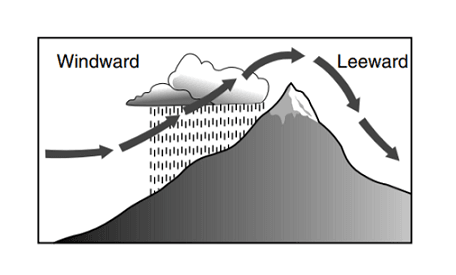
The arrows in the diagram below represent the
movement of air over a mountain.
Clouds are forming on the windward side of this
mountain because the air is
4
30 sec
4.2
Q.
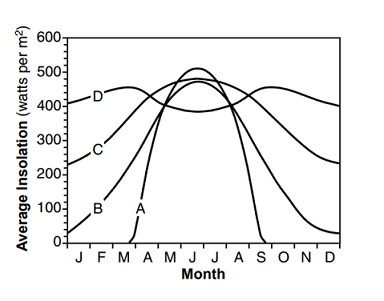
The graph below shows the average monthly
amount of insolation received throughout a year
at four locations (A, B, C, and D) on Earth.
Which line on the graph best represents the
average monthly insolation received at the
equator?
5
30 sec
4.2
Q.
Earth's polar regions have cold, dry climates
because the Sun's rays are at a
6
30 sec
4.2
Q.
Atmospheric transparency will increase when
7
30 sec
4.2
Q.
The fi rst P-wave of an earthquake travels 5600
kilometers from the epicenter and arrives at a
seismic station at 10:05 a.m. At what time did this
earthquake occur?
8
30 sec
4.2
Q.
As a quartz pebble is transported by a stream, the
pebble will become more rounded as a result of
9
30 sec
4.2
Q.
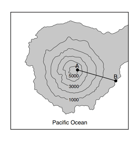
What is the approximate gradient from point A to
point B on the island?
10
30 sec
4.2
Q.
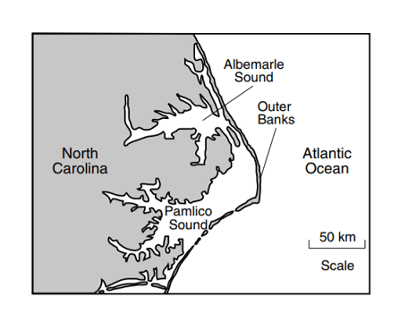
Which agent of erosion is primarily responsible
for the formation of these barrier islands?
11
30 sec
4.2
Q.
Which cross section best represents a cold front?
12
30 sec
4.2
Q.
The surface winds that produced this storm came from which direction?
13
30 sec
4.2
Q.
Which map best shows the complete stream drainage pattern for this mountain?
14
30 sec
4.2
Q.
Which table best represents the characteristics of the continental crust and the oceanic crust?
15
30 sec
4.2
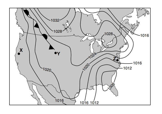
Q.
Which map information indicates that the wind velocity is greater at location Z than at location X?
16
30 sec
4.2
Q.
Which type of front extends northwest from location Y?
17
30 sec
4.2
Q.
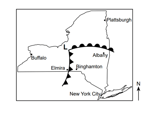
Which map best shows the locations for the centers of high pressure (H) and low pressure (L)?
18
30 sec
4.2
Q.
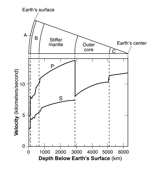
Which layers of Earth's interior are represented by letters A and B?
19
30 sec
4.2
Q.
What is the approximate velocity in kilometers/second of the P-waves at a depth of 1000 kilometers?
20
30 sec
4.2
Q.
21
30 sec
4.2
Q.
The streambank at location B is steeper than the streambank at location A because the water near
location B is moving
22
30 sec
4.2
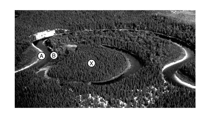
Q.
The area labeled letter X represents a portion of a
23
30 sec
4.2
Q.
Most of the particles deposited where the stream velocity decreases from 50 centimeters per second to
5 centimeters per second are
24
30 sec
4.2
Q.
25
30 sec
4.2
Q.
Clouds are formed when moist, rising air
26
30 sec
4.2
Q.
Specific heat is used to explain why different
substances
27
30 sec
4.2
Q.
Which two mantle hot spots are located at midocean ridges?
28
30 sec
4.2
Q.
29
30 sec
4.2
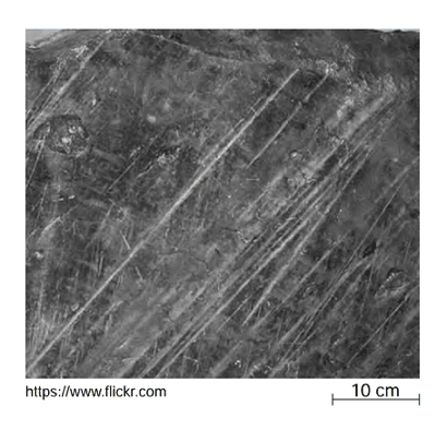
Q.
The photograph below shows parallel scratches
on the surface of limestone bedrock near
Rochester, New York
These parallel scratches were most likely
caused by
30
30 sec
4.2
Q.
Landscapes with a faulted and folded surface
bedrock structure, steep slopes, and high
elevations are classified as
31
30 sec
4.2
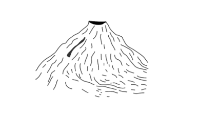
Q.
The diagram below represents a volcano.
Which stream drainage pattern would most likely
form on the entire surface of this volcano?
32
30 sec
4.2
Q.
What is the largest particle size that a stream
can transport at a velocity of 5 centimeters per
second?
33
30 sec
4.2
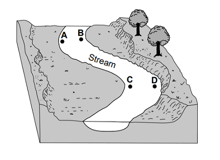
Q.
The diagram below represents a portion of a
meandering stream. Letters A, B, C, and D
represent locations on the bottom of the stream.
At which two locations would the stream most
likely be the deepest?
34
30 sec
4.2
Q.
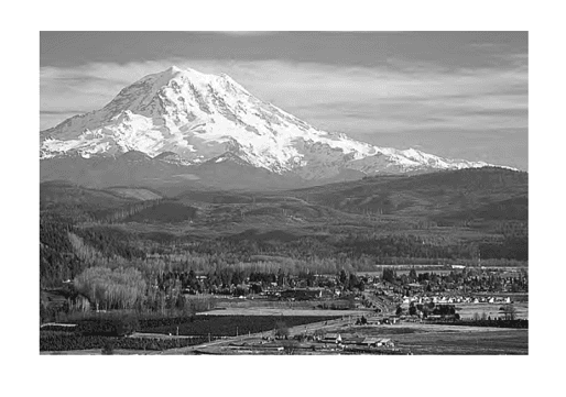
The block diagrams below represent two large regions on Earth's surface.
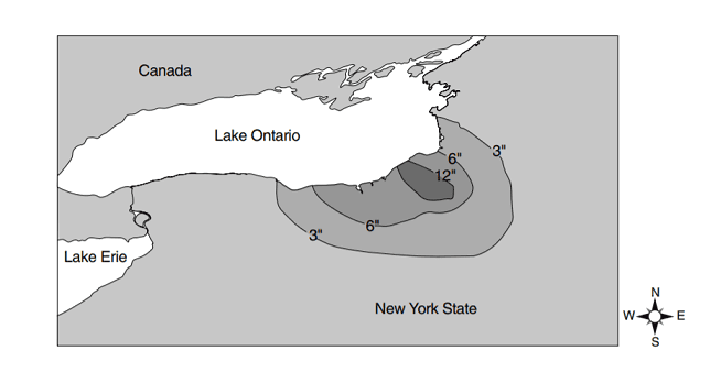
Compared to the white sandy region, the vegetative region is
35
30 sec
4.2
Q.
Which diagram best represents sediments with the greatest degree of sorting by size?
36
30 sec
4.2
Q.
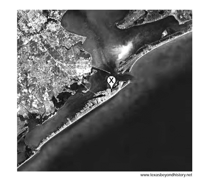
The photograph below shows a depositional feature located near the shore of Texas. Letter X represents a location on this feature.
On which depositional feature is location X found?
37
30 sec
4.2
Q.
Which statement best describes the arrival of P-waves and S-waves recorded at a station located closer to the epicenter of this same earthquake?
38
30 sec
4.2
Q.
The rock movement that caused the earthquake occurred 10 kilometers below Earth's surface. In which
Earth layer did this earthquake originate?
39
30 sec
4.2
Q.
If the center of the low-pressure system follows a normal storm track, toward which city would the center of this low most likely move?
40
30 sec
4.2
Q.
Severe weather was occurring in Elmira, New York. Which present weather symbol was most likely recorded
on the station model for Elmira?
41
30 sec
4.2
Q.
Which map shows the most probable areas of precipitation that would appear on a radar image taken at the time of these frontal positions?
42
30 sec
4.2
Q.
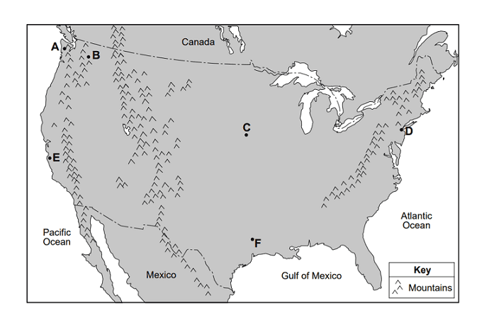
The climate of location A is more humid than location B because A is
43
30 sec
4.2
Q.
Compared to the annual range in temperatures at location C, the annual range in temperatures at
location D will be
44
30 sec
4.2
Q.
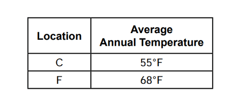
The table below compares the average annual temperature for locations C and F.
The best explanation for this temperature difference is that location C
45
30 sec
4.2
Q.
What is the relative temperature and name of the surface ocean current that affects the climate of
location E?