Tag the questions with any skills you have. Your dashboard will track each student's mastery of each skill.
Give this quiz to my class
Q 1/25
Score 0
The Pineywoods region of Texas has over 85 species of trees and over a thousand species of flowering plants. What is true about erosion in this region?
30
The plants soak up all the water drying the soil leaving it exposed to erosion
There is lots of soil erosion due to the large amount of vegetation
The falling leaves act as compost and fertilize the soil
There is little soil erosion due to the large amount of vegetation, Plants roots keep the soil in place.
Q 2/25
Score 0
Why is soil erosion more common in ecoregions that lack adequate vegetation?
30
because plant roots help keep the soil in place
because soil erosion is stopped by reduced vegetation
because gravity pulls on the plants and increases erosion
because the lack of adequate vegetation affects the soil pressure and erosion rate
25 questions
Q.
The Pineywoods region of Texas has over 85 species of trees and over a thousand species of flowering plants. What is true about erosion in this region?
1
30 sec
Q.
Why is soil erosion more common in ecoregions that lack adequate vegetation?
2
30 sec
Q.
Sixty percent of the Texas Gulf Coast shoreline erodes from 30cm to 15m per year. This results in
3
30 sec
Q.
According to the figure, which eco-region in Texas would see the most erosion by running water?
4
30 sec
Q.
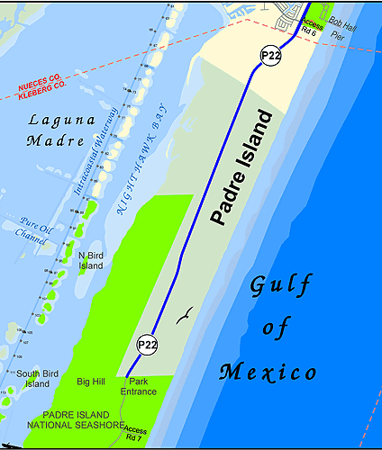
The gulf side of Padre Island have smoother coastlines than their inland coastlines because of the erosional effects of
5
30 sec
Q.
A teacher used a stream table to model how a Texas river changes the surface of the Earth. When the teacher finishes pouring the water, which change will most likely have taken place?
6
30 sec
Q.
How has weathering affected Enchanted Rock?
7
30 sec
Q.
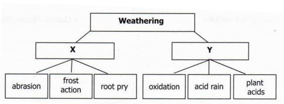
The best choice to place in Box Y of the graphic organizer is __
8
30 sec
Q.
Which of the following would be the most effective way to prevent environmental damage from floods?
9
30 sec
Q.
In late 2004, an earthquake occurred on the bottom of the ocean near the west coast of Indonesia. It was so strong that is caused the entire planet to vibrate 1 cm. What catastrophic events did this create?
10
30 sec
Q.
Earthquakes, volcanic eruptions, tsunamis, and wildfires which impact ecosystems are all examples of
11
30 sec
Q.
Predict which ecosystems in Texas would face the greatest damage due to potential erosion from a hurricane
12
30 sec
Q.
Which of the following best describes how a hurricane can affect a marine ecosystem?
13
30 sec
Q.
How would a hurricane most likely affect the Costal Prairie?
14
30 sec
Q.
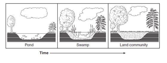
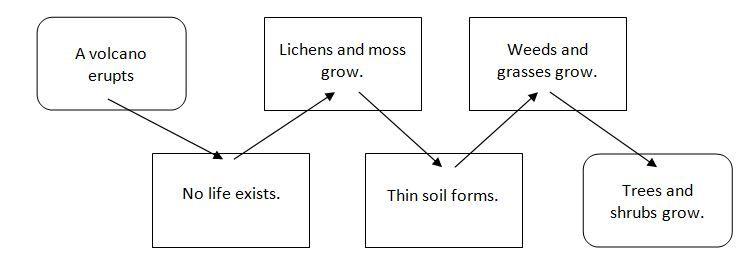
The diagram below shows a sequence of environmental changes in an area over a long period of time. Which statement best describes the changes shown in the diagram?
15
30 sec
Q.
What is the correct ecological sequence of events when a large slab of rock falls off of a mountain?
16
30 sec
Q.
The diagram below shows a series of changes that occurs after a disturbance. This is called __
17
30 sec
Q.
What is the correct sequence of these stages of succession?
18
30 sec
Q.
Which of these would be the first to grow in primary succession after the formation of soil?
19
30 sec
Q.
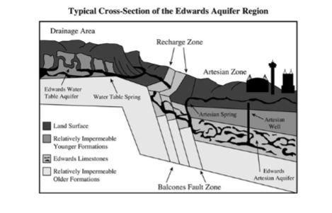
The Edwards Aquifer in south central Texas is the source of water for more than 1.5 million people. Most of the water that feeds into the aquifer originally comes from which of the following locations in the diagram shown above?
20
30 sec
Q.
John was changing oil in his truck. He dumped the used oil around a fence post to keep weeds from growing. John didn’t know it, but he was hurting the environment because the oil
21
30 sec
Q.
What factor most affects the amount of groundwater that enters an aquifer?
22
30 sec
Q.
Heavy rains in an aquifer’s recharge zone (in the watershed area)cause rivers and streams to flood. How will this most likely affect the aquifer?
23
30 sec
Q.
Analyze the following statements about the relationship between a watershed and ground water. Which of the statements best represents the relationship?
24
30 sec
Q.
Which of the following statements illustrate how surface water and ground water are interconnected?