Ancient India Physical Geography
Quiz by Lauren Trench
Feel free to use or edit a copy
includes Teacher and Student dashboards
Measure skillsfrom any curriculum
Measure skills
from any curriculum
Tag the questions with any skills you have. Your dashboard will track each student's mastery of each skill.
With a free account, teachers can
- edit the questions
- save a copy for later
- start a class game
- automatically assign follow-up activities based on students’ scores
- assign as homework
- share a link with colleagues
- print as a bubble sheet


16 questions
Show answers
- Q1(Fill in the blank.) Strong seasonal winds called ________________ bring a dry season in the winter and heavy rains in the summer.monsooncaste systemsanskritbarrier45s
- Q2India is a large landmass in the south of Asia. What is this large landmass called?Indus River Valley CivilizationsubcontinentHimalaya mountainsisolation45s
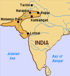
- Q3What are the 2 planned cities that you have labeled on you ancient India Map?Mohenjo-Daro and HarappaIndus and GangesHimalayas and Hindu KushArabian Sea and Indian Ocean45s
- Q4What is silt?dirta farming techniquea type of riverfertile soil for farming45s
- Q5What 2 rivers provided fertile soil for farming in Ancient India?Indus River and the Ganges RiverArabian Sea and the Indian OceanTigris and Euphrates RiversHimalayas and the Hindu Kush45s
- Q6What does agriculture mean?civilizationisolationriversfarming45s
- Q7The Himalayan Mountains create a natural barrier against what kind of threat?foreign invaderskarmamonsoonisolation45s
- Q8What is a barrier?a circumstance or obstacle that keeps people or things apart or prevents communication or progress.to dramatically changewithout mistakes or errorsfar away from other places, buildings, or people; remote45s
- Q9What is isolation?a circumstance or obstacle that keeps people or things apartfar away from other places, buildings, or people; remote, cut off from other civilizationswith hesitation or doubtto rise or appear45s
- Q10What types of physical geography caused Ancient India to be isolated?riversplateauMount Everestmountains and the seas/oceans45s
- Q11What is an invader?a type of civilizationplanned citiesto enter forcefully as an enemy; go into with hostile intentfar away from other places45s
- Q12The river valleys provided rich soil for crops, as well as protection from what?barrieranimal attacksinvasionsisolation20s
- Q13According to the map, where were a large number of sites that belonged to the Indus civilization located?along rivers and the seaalong Bay of Bengalin the desert areasnear the Mediterranean Sea30s
- Q14What statement BEST explains how physical geography affected the development of ancient Mesopotamian and Indus Valley Civilizations?Both civilizations were self-sufficient and did not engage in trade.Both civilizations had arid climates and could not keep food in storage.The seaports provided water access enabling each civilization to become empires.The river valleys provided fertile land enabling a surplus in agriculture.120s
- Q15How are Geographers able to understand why people change their surroundings?They study the relationship between humans and their environment.They study the way population affects geographic regions.They study the way goods, people, and ideas move from one location to another.They study the relationship between neighboring cultures.60s