Aviation Maps - FAA Questions
Quiz by Christian Gibson
Feel free to use or edit a copy
includes Teacher and Student dashboards
Measure skillsfrom any curriculum
Measure skills
from any curriculum
Tag the questions with any skills you have. Your dashboard will track each student's mastery of each skill.
With a free account, teachers can
- edit the questions
- save a copy for later
- start a class game
- automatically assign follow-up activities based on students’ scores
- assign as homework
- share a link with colleagues
- print as a bubble sheet
19 questions
Show answers
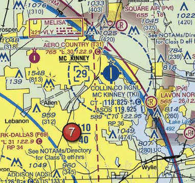
- Q1(See area 7) The airspace overlying Mc Kinney (TKI) is controlled from the surface to2,500 feet MSL.2,900 feet MSL.700 feet AGL.30s
- Q2(See area 1) What type of airspace is over Tomlinson Airport.Class G airspace—surface up to but not including 18,000 feet MSL.Class G airspace—surface up to but not including 1,200 feet AGL, Class E airspace—1,200 feet AGL up to but not including 18,000 feet MSL.Class G airspace—surface up to but not including 700 feet MSL, Class E airspace—700 feet to 14,500 feet MSL.30s
- Q3(See area 3) Identify the airspace over Sprague Airport.Class G airspace - surface up to but not including 700 feet MSL, Class E airspace - 700 feet to 14,500 feet MSL.Class G airspace - surface up to but not including 18,000 feet MSL.Class G airspace - surface up to but not including 1,200 feet AGL, Class E airspace - 1,200 feet AGL up to but not including 18,000 feet MSL.30s
- Q4(See area 5) In order to avoid the Livermore Airport, what minimum altitude could you use to fly over it?2,901 feet MSL.2,503 feet MSL.3,297 feet MSL.30s
- Q5(See area 4) The airspace directly overlying Fort Worth Meacham isClass D airspace to 3,200 feet MSL.Class C airspace to 5,000 feet MSL.Class B airspace to 10,000 feet MSL.30s
- Q6(See area 3) What is the floor of the Savannah Class C airspace at the shelf area (outer circle)?1,300 feet MSL.1,300 feet AGL.1,700 feet MSL.30s
- Q7(See area 4) The floor of Class B airspace overlying Hicks Airport (T67) north-northwest of Fort Worth Meacham Field is3,200 feet MSL.at the surface.4,000 feet MSL.30s
- Q8The flag symbols at Statesboro Bullock County Airport, Claxton-Evans County Airport, and Ridgeland Airport areairports with special traffic patterns.outer boundaries of Savannah Class C airspace.visual checkpoints to identify position for initial callup prior to entering Savannah Class C airspace.30s
- Q9(See Area 5) The CAUTION box denotes what hazard to aircraft?Unmarked balloon on cable to 3,008 feet AGL.Unmarked balloon on cable to 3,008 feet MSL.Unmarked blimp hangers at 300 feet MSL.30s
- Q10Which public use airports depicted are indicated as having fuel?Minot Intl. (area 1).Minot Intl. (area 1) and Garrison (area 2).Garrison (area 2).30s
- Q11The flag symbol at Lake Drummond represents acompulsory reporting point for Norfolk Class C airspace.compulsory reporting point for Hampton Roads Airport.visual checkpoint used to identify position for initial callup to Norfolk Approach Control.30s
- Q12The top of the group obstruction approximately 11 nautical miles from the Savannah VORTAC on the 008° radial is310 feet AGL.454 feet MSL.432 feet MSL.30s
- Q13The navigation facility at Sulphur Springs (SLR) is a:VOR/DMEADFVOR30s
- Q14What is the height of the lighted obstacle approximately 6 nautical miles southwest of Savannah International?1,531 feet AGL.1,548 feet MSL.1,500 feet MSL.30s
- Q15Which description below accurately describes the colors used for airports on a Sectional Chart?Airports with control towers underlying Class D and E airspace are magenta.Airports with control towers are shown in magenta.Airports with control towers are shown in blue.30s
