Loading...
Climate Change Learning Cycle 1
Quiz by Russ Drylie
Customize this quiz to suit your class
Instantly translate to 100+ languages
Tag the questions with any skills you have. Your dashboard will track each student's mastery of each skill.
Give this quiz to my class
Which of these best explains how changes in the shape of Earth’s orbit and changes in the tilt o fEarth’s axis of rotation cause changes in climate?
These factors affect the sun’s energy output
These factors affect plate tectonic activity and the locations of continents
These factors affect the rate of carbon exchange between the biosphere and atmosphere.
These factors affect the intensity and distribution of sunlight hitting the Earth.
A planet’s distance from the sun affects its
input of energy
output of energy
storage and redistribution of energy
Which of these best explains how changes in the shape of Earth’s orbit and changes in the tilt o fEarth’s axis of rotation cause changes in climate?
A planet’s distance from the sun affects its
Which energy flows are impacted by a planet’s atmospheric characteristics?
Which energy flows are impacted by a planet’s atmospheric characteristics?
Once ice sheets start to form at the beginning of a glacial period, more energy is
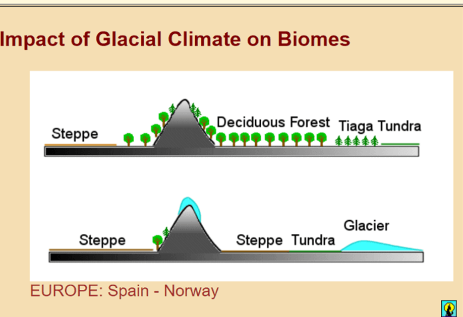
Which of the following is a change the biosphere will have on one of Earth's other spheres during the glacial period?
How would a volcanic eruption change Earth's energy budget?
Geologists refer to the mineral formations in caves as“speleothems.” While the water flows, the speleothems grow in thin, shiny layers. The amount of growth is an indicator of how much ground water dripped into the cave. When the speleothems stop growing, the outside becomes dirty and eroded in places, giving it a dull appearance. A growing speleothem looks smooth and wet.”
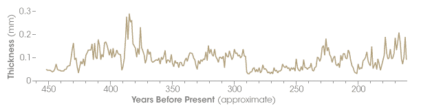
“The cross section of a stalagmite reveals a sequence of layers, similar to the growth rings of trees, laid down over time. Researchers determine the ages of the layers using Uranium-Thorium radiometric dating, andexamine layer thickness and oxygen isotopes to determine past climate.”
Based on the information provided, what do scientists measure in order to study the relationship between speleothems and past climate?
Geologists refer to the mineral formations in caves as“speleothems.” While the water flows, the speleothems grow in thin, shiny layers. The amount of growth is an indicator of how much ground water dripped into the cave. When the speleothems stop growing, the outside becomes dirty and eroded in places, giving it a dull appearance. A growing speleothem looks smooth and wet.”
“The cross section of a stalagmite reveals a sequence of layers, similar to the growth rings of trees, laid down over time. Researchers determine the ages of the layers using Uranium-Thorium radiometric dating, andexamine layer thickness and oxygen isotopes to determine past climate.”
Based on the information provided, what do scientists measure in order to study the relationship between speleothems and past climate?
Based on the information provided the graph, which of these best identifies the purpose of the data analysis displayed?
Geologists refer to the mineral formations in caves as“speleothems.” While the water flows, the speleothems grow in thin, shiny layers. The amount of growth is an indicator of how much ground water dripped into the cave. When the speleothems stop growing, the outside becomes dirty and eroded in places, giving it a dull appearance. A growing speleothem looks smooth and wet.”
“The cross section of a stalagmite reveals a sequence of layers, similar to the growth rings of trees, laid down over time. Researchers determine the ages of the layers using Uranium-Thorium radiometric dating, andexamine layer thickness and oxygen isotopes to determine past climate.”