Loading...
GEOGRAPHY GRADE 10(PRACTICE PAPER 6) ICSE
Quiz by Sangeeta Mishra
Tag the questions with any skills you have. Your dashboard will track each student's mastery of each skill.
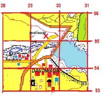
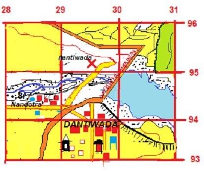
What are the settlement types in grid 2993?
a. Permanent and Linear
a. Compact and Nucleated
a. Linear and Compact
a. Temporary and Permanent
What are the facilities available at Dantiwada in grid 2993?
a) Hospital, PO, IB
a) Inspection Bungalow, PS, PO
a) Post office,Police Station, RestHouse
a) PO, Rest House,Overhead Tank
What are the settlement types in grid 2993?

What are the facilities available at Dantiwada in grid 2993?

What does the x symbol at Dantiwada (2995) indicates?

Calculate in km the length of the district road which is 8cm.

Assuming that you are travelling at a speed of 1km/ h, calculate the time that you will take to travel east to west.

Why is there a disappearing drainage
Pattern in grid 6234?

What is the difference between two tanks in grids 6334 and 6434?

What type of dam is seen here?

One natural and one man- made feature in 2995:

What do the black small lines in grid 3095 indicate

The climate of India is greatly influenced by which latitude?
The climate of India can be described as
Temperature does not rise much even in summer at :-
This place experiences highest rainfall in India.
The pre monsoon wind experienced in Karnataka.
Thar Desert receives less rainfall as this mountain runs parallel to the rain bearing wind.
Name the driest month.

Calculate the annual range of temperature.

Name the monsoon wind blowing over Bay of Bengal.

Monsoon winds bring this type of rainfall.
Identify the tree (given in the picture)leaves of which are used for rearing shellac worms.

Why is the forest floor quite dark in tropical evergreen forests?
Which of the following climatic factors are appropriate for the growth of tropical monsoon forests?
Teak wood is commonly used for house construction and furniture making because
Mangrove forests protect the environment by
The practice of growing trees on farm land to produce saleable products like timber, tannin etc. and to provide shade for stock and crops is called.
Plugging of gullies and ravines are practiced in the regions of
Crop Rotation technique in agriculture helps in
19. This is not faulty method of agriculture
The Alluvium soil in the upper course is
Observe the picture given and identify the type of soil used.

The soil is useful for growing coffee in Karnataka.
Black soil is deficient in
Why do we need to conserve water?
The water shed development initiated by
central government is called ____________________. .
Name the process of watering agricultural plants by artificial means.
Study the picture and state the objectives of the following water conservation method.

Name the water conservation mission set up by the government of Andhra Pradesh.
Why canals are constructed in flat land and soft soil?
Name the modern method of irrigation that gives water directly to the crops through root lines.