![placeholder image to represent content](/_next/image?url=%2Fassets%2Fquiz_default_logo.jpg&w=256&q=75)
Geography Review Game
Quiz by Justin Mullen
Feel free to use or edit a copy
includes Teacher and Student dashboards
Measure skillsfrom any curriculum
Tag the questions with any skills you have. Your dashboard will track each student's mastery of each skill.
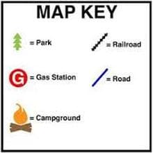
- edit the questions
- save a copy for later
- start a class game
- automatically assign follow-up activities based on students’ scores
- assign as homework
- share a link with colleagues
- print as a bubble sheet
- Q1
What is a map key?
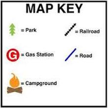
A value used to access a specific element in a map
A coordinate system used in cartography
A visual representation of a map
A data structure to hold geographical information
30s - Q2
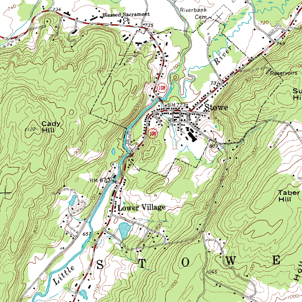
What type of map shows the physical features of an area, such as mountains, rivers, and lakes?
Political Map
Road Map
Topographic Map
Weather Map
30s - Q3
What type of map is used to navigate and find directions?
Thematic Map
Navigational Map
Political Map
Physical Map
30s - Q4
What type of map shows the boundaries and political divisions between different countries, states, or regions?
Political Map
Topographic Map
Weather Map
Special Purpose Map
30s - Q5
Which type of map is used to show the landforms and elevation of an area?
Thematic Map
Climate Map
Political Map
Topographic Map
30s - Q6
What does a scale on a map represent?
The elevation of the land
The direction of North
The population density of an area
The relationship between a distance on the map and the corresponding distance on the ground.
30s - Q7
What is latitude on a map?
The distance between two cities
The distance north or south from the equator
The total area covered by the map
The distance east or west from the prime meridian
30s - Q8
What is longitude?
The measurement of how hot or cold a location is
The measurement of how far north or south a location is from the equator.
The measurement of how far east or west a location is from the prime meridian
The measurement of how high a location is above sea level.
30s - Q9
Which of the following shows all 5 oceans?
Atlantic, Pacific, Indian, Arctic, Southern
Atlantic, Specific, Canadian, Indian, Antarctic
Pacific, Atlantis, South, North, Arctic
Atlantis, Specific, African, Southy, Norhty
30s - Q10
What is a continent?
A large, continuous area of land on Earth
A collection of lakes and rivers
An underwater mountain range
A small, isolated island
30s - Q11
Which of the following correctly defines a country?
A group of people with similar cultural backgrounds.
A group of people living together in a specific region.
A geographic area with natural resources.
A politically organized body of people occupying a definite territory, legally recognized as independent and sovereign.
30s - Q12
Which state is not part of the Northeast region of the U.S.?
New York
Texas
Massachusetts
Maine
30s - Q13
What is the Great Plains?
A desert in Africa
A vast grassland region in North America
A mountain range in Europe
A tropical rainforest in South America
30s - Q14
What is the difference between a continent and a country?
A continent is bigger than a country.
A continent is a large landmass that consists of multiple countries, while a country refers to a specific political and geographical territory.
A continent is a term used for underwater landmasses, while a country is a term used for above-water landmasses.
A continent is a political entity, while a country is a geographical territory.
30s - Q15
What is the biggest continent in the world?
Africa
Oceania
North America
Asia
30s