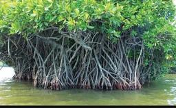
Loading...

Mangrove Forests
Quiz by NIDHI MATHUR
Customize this quiz to suit your class
Instantly translate to 100+ languages
Tag the questions with any skills you have. Your dashboard will track each student's mastery of each skill.
Give this quiz to my class
​Mangroves are _____________________ trees that grow in saltwater.
very tall
big
small
very short
​Mangroves forests are also called "guardians of the coast".
Mangroves are _____________________ trees that grow in saltwater.
Mangroves forests are also called "guardians of the coast".
Mangroves soak more than ______ of carbon dioxide than other plants.
Mangrove trees are known as _____ in UAE.
Jubail Mangrove park is in _______.
Khor Al Beidah welands are in __________.
India Where Is It? India is a country in Asia. Much of it is surrounded by water. To the south and west is the Arabian Sea. To the south and east is the Bay of Bengal. The capital of India is New Delhi (DEL-ee). It is part of the much larger city of Delhi. More than twenty million people live in Delhi and New Delhi. People. More than one billion people live in India. Only China has more people than India. Most Indian people live in the countryside. The cities do not have as many people. They are very crowded, though. Around half of the people in India make their living from growing food. They grow crops or raise sheep, goats, and chickens for meat. They do not raise cows for meat. Most Indians are Hindu. Hurting a cow is against the Hindu religion. Land. India has many mountains and different kinds of flat land. The mountains are in the north. They are the highest in the world. Rich land covers the north of India. It was formed long ago as rivers flooded over and over. In the west is the dry desert. In the south is raised, flat land. This land takes up more than half of India. In May or June every year, winds bring a large amount of rain. This is called the monsoon season. Most of India's rain falls during this season. Celebrations People in India celebrate many special days. Diwali (dih-WAH-lee) lasts for five days. During this festival, people light small candles. They shoot firecrackers and give sweets to family and friends. Holi (HOH-lee) is a spring Hindu festival. During Holi, people celebrate the end of winter. They throw colored water and powder on each other. Animals. Many kinds of animals live in India. It is the only country in the world with both lions and tigers. Elephants live in the flat lands and forests. The mountains are home to bears, foxes, sheep, and wild goats. India is also home to the world's largest mangrove forest. Here, tigers swim with sea turtles, sharks, and crocodiles. Conclusion. India is a country of many people. People farm its rich soil to feed the nation. Its mountains and forests are home to many animals. Which part of India would you like to see?
Soils Southeast Asia, on balance, has a higher proportion of relatively fertile soils than most tropical regions, and soil erosion is less severe than elsewhere. Much of the region, however, is covered by tropical soils that generally are quite poor in nutrients. Often the profusion of plant life is more related to heat and moisture than to soil quality, even though these climatic conditions intensify both chemical weathering and the rate of bacterial action that usually improve soil fertility. Once the vegetation cover is removed, the supply of humus quickly disappears. In addition, the often heavy rainfall leaches the soils of their soluble nutrients, hastens erosion, and damages the soil texture. The leaching process in part results in laterites of reddish clay that contain hydroxides of iron and alumina. Laterite soils are common in parts of Myanmar, Thailand, and Vietnam and also occur in the islands of the Sunda Shelf, notably Borneo. The most fertile soils occur in regions of volcanic activity, where the ejecta is chemically alkaline or neutral. Such soils are found in parts of Sumatra and much of Java in Indonesia. The alluvial soils of the river valleys also are highly fertile and are intensively cultivated. Climate All of Southeast Asia falls within the warm, humid tropics, and its climate generally can be characterized as monsoonal (i.e., marked by wet and dry periods). Changing seasons are more associated with rainfall than with temperature variations. There is, however, a high degree of climatic complexity within the region. Temperatures Regional temperatures at or near sea level remain fairly constant throughout the year, although monthly averages tend to vary more with increasing latitude. Thus, with the exception of northern Vietnam, annual average temperatures are close to 80 °F (27 °C). Increasing elevation acts to decrease average temperatures, and such locations as the Cameron Highlands in peninsular Malaysia and Baguio in the Philippines have become popular tourist destinations in part because of their relatively cooler climates. Proximity to the sea also tends to moderate temperatures. Precipitation Much of Southeast Asia receives more than 60 inches (1,500 millimeters) of rainfall annually, and many areas commonly receive double and even triple that amount. The rainfall pattern is distinctly affected by two prevailing air currents: the northeast (or dry) monsoon and the southwest (or wet) monsoon. The northeast monsoon occurs roughly from November to March and brings relatively dry, cool air and little precipitation to the mainland. As the southwestward-flowing air passes over the warmer sea, it gradually warms and gathers moisture. Precipitation is especially heavy where the airstream is forced to rise over mountains or encounters a landmass. The east coast of peninsular Malaysia, the Philippines, and parts of eastern Indonesia receive the heaviest rains during this period. The southwest monsoon prevails from May to September, when the air current reverses and the dominant flow is to the northeast. The mainland receives the bulk of its rainfall during this period. Over much of the southern Malay Peninsula and insular Southeast Asia there is little or no prolonged dry season. This is especially marked in much of the equatorial region and along the east coast of the Philippines. While the dry and wet monsoons are important in explaining rainfall patterns, so too are such factors as relief, land and sea breezes, convectional overturning and cyclonic disturbances. These factors often are combined with monsoonal effects to produce highly variable rainfall patterns over relatively short distances. While many of the cyclonic disturbances produce only moderate rainfall, others mature into tropical storms—called cyclones in the Indian Ocean and typhoons in the Pacific—that bring heavy rains and destruction to the areas over which they pass. The Philippines are particularly affected by these storms. Plant life Tropical forests in Southeast Asia Tropical forests in Southeast Asia The seasonal nature and pattern of Southeast Asia’s rainfall, as well as the region’s physiography, have strongly affected the development of natural vegetation. The hot, humid climate and enormous variety of habitats have given rise to an abundance and diversity of vegetative forms unlike that in any other area of the world. Much of the natural vegetation has been modified by human action, although large areas of relatively untouched land still can be found. The vegetation can be grouped into two broad categories: the tropical-evergreen forests of the equatorial lowlands and the open type of tropical-deciduous, or “monsoon,” forests in areas of seasonal drought. The evergreen forests are characterized by multiple stories of vegetation, consisting of a variety of trees and plants. Although a large diversity of tree species is found in these forests, members of the Dipterocarpaceae family account for roughly half of the varieties. Deciduous forests are found in eastern Indonesia and those parts of the mainland where annual rainfall does not exceed 80 inches. Just as in the equatorial forest, a wide variety of species is normally the rule. Certain species, such as teak, have become highly valued commercially. Teak is found in parts of Indonesia, Myanmar, Thailand, and Laos. In addition to these two basic types of vegetation, other regional patterns reflect topography. Especially noteworthy are coastal and highland plant communities. Mangrove belts, of which there are more than 30 varieties, occur where silt is deposited in coastal areas. Upland forests dominated by maples, oaks, and magnolias are found especially on mainland mountain slopes. Human activity has been rapidly altering the stands of virgin forest in Southeast Asia. Most deforestation results from removal for fuelwood and clearing for agriculture and grazing. Although only a relatively small portion of the total land area has been permanently cleared for cultivation—e.g., in Java (Indonesia) and western Luzon (the Philippines)—in some areas shifting cultivation has brought about the replacement of virgin forest with secondary growth. In addition, nearly all countries have commercial logging industries; notable are those in Indonesia, Malaysia, Thailand, and Myanmar. A growing problem has been illegal logging. Thus, timber harvesting has come to contribute significantly to deforestation. Programs in social forestry and reforestation have yet to halt the rapid denuding of the landscape. Animal life Southeast Asia is situated where two major divisions of the world’s fauna meet. The region itself constitutes the eastern half of what is called the Oriental, or Indian, zoogeographic region (part of the much larger realm of Megagaea). Bordering along the south and east is the Australian zoogeographic region, and the eastern portion of insular Southeast Asia—Celebes (Sulawesi), the Moluccas, and the Lesser Sunda Islands—constitutes a transition zone between these two faunal regions. a classroom in Brazil More From Britannica education: Southeast Asia Southeast Asia is notable, therefore, for a considerable diversity of wildlife throughout the region. These differences are especially striking between the species of the eastern and western fringes as well as between those of the archipelagic south and the mainland north. The differences stem largely from the isolation, over varying lengths of geologic time, of species following their migration from the Asian continent. In addition, the tropical rain forests in many parts of the region, with their great diversity of vegetation, have made possible the development of complex communities of animals that fill specialized ecological niches. Especially numerous are arboreal and flying creatures. orangutans orangutansOrangutans (Pongo pygmaeus) in Sumatra, Indonesia. The distinction between the two faunal regions is best depicted by their mammal populations. In general, Australia is inhabited largely by marsupials (pouched mammals) and monotremes (egg-laying mammals), while Southeast Asia contains placental mammals and such hybrid species as the bandicoot of eastern Indonesia. Small mammals such as monkeys and shrews are the most numerous, while in many areas the larger mammals have been pushed into more remote areas and national preserves. Bears, gibbons, elephants, deer, civets, and pigs are found in both mainland and insular Southeast Asia, as are diminishing numbers of tigers. The Malayan tapir, a relative of the rhinoceros, is native to the Malay Peninsula and Sumatra, while the tarsier is found in the Philippines and parts of Indonesia. A number of rare endemic species are found in Indonesia and East (insular) Malaysia, including the Sumatran and Javan rhinoceros, the orangutan, the anoa (a dwarf buffalo), the babirusa (a wild swine), and the palm civet. As the pace of development accelerates and populations continue to expand in Southeast Asia, concern has increased regarding the impact of human activity on the region’s environment. A significant portion of Southeast Asia, however, has not changed greatly and remains an unaltered home to wildlife. The nations of the region, with only few exceptions, have become aware of the need to maintain forest cover not only to prevent soil erosion but to preserve the diversity of flora and fauna. Indonesia, for example, has created an extensive system of national parks and preserves for this purpose. Even so, such species as the Javan rhinoceros face extinction, with only a handful of the animals remaining in western Java
Mangroves: forests of the seas
Class activity 1: Crop distribution refers to how crops are spread across different regions in Nigeria. Certain crops are found more in one area than the rest because of the environment in which they grow best. Successful adaptation of crops to the climatic and soil conditions of an area is known as Adaptability. Different crops require different climatic and soil conditions for their normal growth and development. THREE ECOLOGICAL REGIONS IN NIGERIA 1. Coastal region 2. Rainforest region 3. Savanna region Coastal region: This region is close to the sea and is marked by mangrove forest. The climate there is humid and receives lots of rainfall. Dominant Crops: Rice, rubber, coconut. States found: Akwa-Ibom, Bayelsa, Cross-Rivers, Delta, Edo, Lagos, Ogun, Ondo and Rivers. RAINFOREST REGION(SOUTH): This region experiences high rainfall throughout the year and lush vegetation. Dominant Crops: Oil palm, banana, plantain, kolanut, cocoa, tubers(cassava and yam). States found: Bayelsa, Cross River, Edo, Ekiti, Ondo, Osun, Rivers, and Taraba. SAVANNAH REGION(NORTH): This region has a dry and wet season with less rainfall than the forest region. It consists of grassland and a few trees. Dominant Crops cereals, legumes, and cotton. These crops adapt to the drier and warmer climate of the savannah and require less water. States found: Enugu, Ekiti, Osun, Oyo, Kwara, Kogi, Benue, Nassarawa, Plateau, and Taraba States
The Benin Kingdom is located in the southern forest of West Africa (Modern Nigeria) and formed by the Edo people, flourished from the 13th to 19th century CE. The capital also is called Benin, it was the hub of a trade network exclusively controlled by the king or Oba and which included relations with Portuguese traders who sought gold and slaves. Benin went into decline during the 18th century. The Benin territory is a mixture of rainforest, dry forest, and mangrove swamp. The heartland was a circle around the capital, also called Benin, extending some 60 kilometers in all directions and was ruled directly by the king. THE OBA OF BENIN This is the traditional ruler and the custodian of the culture of the Edo people and all Edoid people. THE FOLLOWING ARE THE PAST OBAS OF BENIN KINGDOM AND YEAR OF REIGNING. 1. Pre – Imperial Benin (1200- 1440) Eweka 1 (1200 -1235), Uwakhuahen (1235 – 1243), Ehenmihen (1243 – 1255). 2. Imperial Benin ((1440 – 1897) Ewuare the Great (1440 – 1473), Olua (1473 -1480), Ozolua(1483 – 1504). 3. Post- Imperial Benin (1914- Present) Eweka II(1914 – 1933) Akenzua II (1933 – 1978) Erediauwa (1976 – 2016)
The Mangrove Nine
ekosistem mangrove
Importance of mangrove in flood and tsunami