placeholder image to represent content

Mga Lugar sa NCR na Sensitibo sa Panganib

Quiz by Sarah Alzaga

Grade 3
Araling Panlipunan
Philippines Curriculum: Grades K-10 (MELC)

Feel free to use or edit a copy

includes Teacher and Student dashboards

Measures 1 skill from
Grade 3
Araling Panlipunan
Philippines Curriculum: Grades K-10 (MELC)

AP3LAR- Ig-h-11

Track each student's skills and progress in your Mastery dashboards

With a free account, teachers can
  • edit the questions
  • save a copy for later
  • start a class game
  • view complete results in the Gradebook and Mastery Dashboards
  • automatically assign follow-up activities based on students’ scores
  • assign as homework
  • share a link with colleagues
  • print as a bubble sheet

Our brand new solo games combine with your quiz, on the same screen

Correct quiz answers unlock more play!

New Quizalize solo game modes
5 questions
Show answers
  • Q1

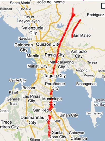
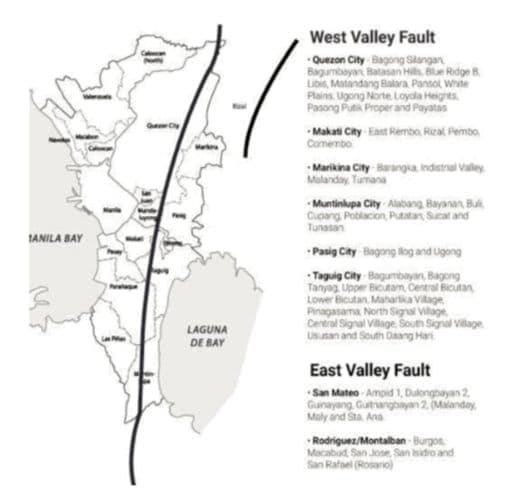
    Batay sa fault line map, ano- anong lungsod ang dinaraanan nito

    Question Image

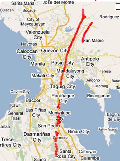
    multiplem://Marikina:Pasig:Makati:Quezon City: Taguig:Muntinlupa

    Manila

    30s
    AP3LAR- Ig-h-11
    Edit
    Delete
  • Q2

    Anong mga lugar sa NCR ang may mataas na antas ng pagbaha?

    Makati

    multiplem:// Marikina:Manila: Quezon City

    30s
    AP3LAR- Ig-h-11
    Edit
    Delete
  • Q3

    Batay  sa fault line map, ilang lungsod  sa Metro Manila ang dinaraanan ng East- West Valley Fault?

    Question Image

    scrambled://anim

    30s
    AP3LAR- Ig-h-11
    Edit
    Delete
  • Q4

    Anong uri ng mapa ang ginamit upang matukoy ang mga lugar na sensitibo sa mga kalamidad

    Climate map

    Hazard map

    Physical map

    Political map

    30s
    AP3LAR- Ig-h-11
    Edit
    Delete
  • Q5

    Anong uri ng mapa ang nagpapakita ng iba't ibang antas ng pagbaha na maaaring maranasan ng mga lungsod o bayan?

    Climate Map

    Hazard Map

    Earthquake Hazard Map

    Flood Hazard Map

    30s
    AP3LAR- Ig-h-11
    Edit
    Delete

Teachers give this quiz to your class