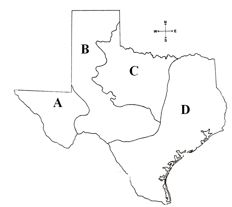
NATURAL TEXAS AND IT'S PEOPLE
Quiz by John Alaniz
Feel free to use or edit a copy
includes Teacher and Student dashboards
Measure skillsfrom any curriculum
Measure skills
from any curriculum
Tag the questions with any skills you have. Your dashboard will track each student's mastery of each skill.
With a free account, teachers can
- edit the questions
- save a copy for later
- start a class game
- automatically assign follow-up activities based on students’ scores
- assign as homework
- share a link with colleagues
- print as a bubble sheet
15 questions
Show answers
- Q1According to the map above, which region has the four largest and most populated cities in Texas?CDBA30s
- Q2According to the map above, which letter represents the location of the Mountains and Basins?DACB45s
- Q3According to the map above, which letter represents the location of the Great Plains?ACBD45s
- Q4Regions of Texas Coastal PlainS--largest, most populous region --Region found along the Gulf Coast, receives the most rainfall each year North Central Plains--mainly agriculturaL--includes Cross Timbers, Grand Prairie, Rolling Plains Great Plains--drier, higher than East TX--includes Edwards Plateau, Llano Basin, High Plains Mountains and Basins--region of majestic peaks, stark deserts--includes the westernmost region of Texas, is the region that receives the least amount of rainfall each year You and your family are considering relocating to Texas in hopes of starting a large produce farm. Based on the chart above, which region would be the best location for the family farm?D. Mountain and BasinsGreat PlainsNorth Central PlainsCoastal Plains45s
- Q5Which of the following is a contributing factor as to why the Coastal Plains region receives more rainfall each year than any other Texas region?The region contains a large amount of farms.The region is located nearest to the Gulf of MexicoThere is a high population living in the region.There are more mountains located in the region45s
- Q6The cooler temperatures in the Great Plains are due largely to the region’smountains and deserts.high elevationcloseness to the Gulf of Mexico.low elevation and humidity.45s
- Q7• Decline of grassland • Flash flooding, rapid runoffs • Large amounts of wave action • Hurricanes Which of the following best completes the graphic organizer above?alluvialD. butteerosiondrought45s
- Q8Column A Column B Bodies of Water Rio Grande Brazos River Trinity River Major Cities El Paso Dallas Alpine Austin Environment Can Experience Can experience Occurrences long periods of hurricanes droughts Which region of Texas is best represented by Column A?Gulf Coastal PlainsGreat PlainsMountains and BasinsCentral Plains45s
- Q9Column A Column B Bodies of Water Rio Grande Brazos River Trinity River Major Cities El Paso Dallas Alpine Austin Environment Can Experience Can experience Occurrences long periods of hurricanes droughts Which region of Texas is best represented by Column B?Great PlainsGulf Coastal PlainsCentral PlainsMountains and Basins45s
- Q10I. Lived in the fertile land of East Texas II. Raised crops III. Settled permanent villages IV. Lived in cities built in the sides of cliff Which of the above are true statements about the Southeastern tribes?III, II, and I onlyIV and IIIIVIV and III45s
- Q11What conclusion can be drawn regarding Early Texans using the information in the chart above?The lifestyle of all tribes was impacted by the region in which they lived.Extreme weather in Texas caused all tribes to become nomads.All tribes worked together in order to develop into complex societies.Each of the Texas tribes shared in common cultural practices.45s
- Q12• 6,000 Galveston resident died • Many Galveston businesses were destroyed • Lost all lines of communication • Galveston residents built an 18 foot seawall Which of the following extreme weather conditions caused the effects mentioned in the bullets above in Texas during the 1900s?droughtnortherB. blizzardhurricane45s
- Q13Austin, the capital of Texas, is located on what river?Red RiverColorado RiverSabine RiverBrazos River45s
- Q14In terms of its physical and human characteristics, Texas can be divided into how many regions?142345s
- Q15The image above depicts a practice common amongst which American Indian culture?AztecsPlainsGulfSoutheastern45s
