Summarize evidence that Earth’s oceans are a reservoir of nutrients, minerals, dissolved gases, and life forms:
• Estuaries
• Marine ecosystems
• Upwelling
• Behavior of gases in the marine environment
• Value and sustainability of marine resources
• Deep ocean technology and understandings gained
Predict the safety and potability of water supplies in North Carolina based on physical and biological factors, including:
• Temperature
• Dissolved oxygen
• pH
• Nitrates and phosphates
• Turbidity
• Bio-indicator
Conclude that the good health of humans requires:
• Monitoring of the hydrosphere
• Water quality standards
• Methods of water treatment
• Maintaining safe water quality
• Stewardship
Track each student's skills and progress in your Mastery dashboards
Give this quiz to my class
Q 1/10
Score 0
Most of the earth's surface is covered by
30
freshwater
water
land
ice
Q 2/10
Score 0
An example of an estuary is
30
Lake Superior
the Atlantic Ocean
Pamlico Sound
the Catawba River
10 questions
Q.
Most of the earth's surface is covered by
1
30 sec
8.E1.1
Q.
An example of an estuary is
2
30 sec
8.E1.1
Q.
The place where salt water from the ocean mixes with fresh water from rivers and streams is called
3
30 sec
8.E1.1
Q.
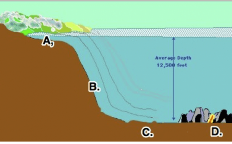
In the picture of the ocean floor, letter B marks what landform?
4
30 sec
8.E1.2
Q.
Some ocean currents are caused by differences in the density of water from place to place around the globe. What two factors cause differences in ocean water density?
5
30 sec
8.E1.2
Q.
What pH level should drinking water have?
6
30 sec
8.E1.3
Q.
Which is a possible solution to protect North Carolina residents from the effects of harmful algal blooms?
7
30 sec
8.E1.3
Q.
Water conservation is an important issue for many reasons. However, water conservation does not
8
30 sec
8.E1.4
Q.
Many different tools are used to monitor the hydrosphere. Which is the BEST example of a bioindicator?
9
30 sec
8.E1.4
Q.
Which stormwater device does the best job of retaining the water and aiding in nutrient removal?