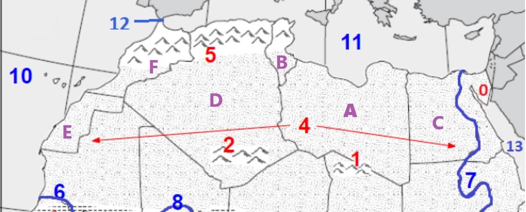
Northern Africa Physical/Political Geomap Review
Quiz by Angela Lortie
Feel free to use or edit a copy
includes Teacher and Student dashboards
Measure skillsfrom any curriculum
Measure skills
from any curriculum
Tag the questions with any skills you have. Your dashboard will track each student's mastery of each skill.
With a free account, teachers can
- edit the questions
- save a copy for later
- start a class game
- automatically assign follow-up activities based on students’ scores
- assign as homework
- share a link with colleagues
- print as a bubble sheet
15 questions
Show answers
- Q1What LANDFORM is labeled #0?SaharaSinai PeninsulaTibesti MountainsSahel30s
- Q2What MOUNTAIN RANGE is labeled #2?Ahaggar MountainsTibesti MountainsAtlas Mountains30s
- Q3What LANDFORM is labeled #4?Sinai PeninsulaTibesti MountainsSaharaSahel30s
- Q4What MOUNTAIN RANGE is labeled #5?Atlas MountainsAhaggar MountainsTibesti Mountains30s
- Q5What RIVER is labeled #7?Senegal RiverNile RiverGambia RiverNiger River30s
- Q6What BODY OF WATER is labeled #10?Mediterranean SeaRed SeaStraight of GibraltarAtlantic Ocean30s
- Q7What BODY OF WATER is labeled #11?Atlantic OceanMediterranean SeaStraight of GibraltarRed Sea30s
- Q8What BODY OF WATER is labeled #12?Atlantic OceanMediterranean SeaRed SeaStraight of Gibraltar30s
- Q9What BODY OF WATER is labeled #13?Red SeaMediterranean SeaAtlantic OceanStraight of Gibraltar30s
- Q10What COUNTRY is labeled A?MoroccoLibyaTunisiaWestern Sahara30s
- Q11What COUNTRY is labeled B?MoroccoWestern SaharaEgyptTunisia30s
- Q12What COUNTRY is labeled C?LibyaEgyptTunisiaAlgeria30s
- Q13What COUNTRY is labeled D?AlgeriaMoroccoTunisiaLibya30s
- Q14What COUNTRY is labeled E?TunisiaAlgeriaWestern SaharaMorocco30s
- Q15What COUNTRY is labeled F?TunisiaMoroccoAlgeriaWestern Sahara30s
