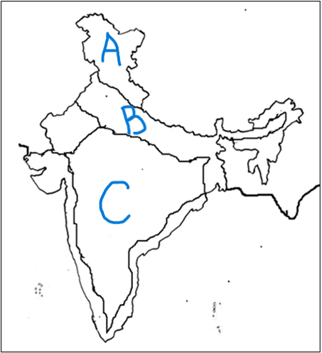
NORTHERN PLAINS
Quiz by RITIKA OBEROI
Customize this quiz to suit your class
Instantly translate to 100+ languages
Tag the questions with any skills you have. Your dashboard will track each student's mastery of each skill.
The Northern Plains stretch from
Punjab in the west to Assam in the east
Punjab in the east to Assam in the west
The rivers carry soil, small pieces of rocks and silt and deposit them in the plains. The fine soil or silt is called__________
Give this quiz to my class
The Northern Plains stretch from
The rivers carry soil, small pieces of rocks and silt and deposit them in the plains. The fine soil or silt is called__________
Punjab, Haryana, Uttar Pradesh, Jammu and Kashmir, Bihar, West Bengal are some states located in the Northern Plains
Northern Plains are located _____________________ of the Himalayas
Choose the correct one

States of Northern Plains
Between 1775 and 1782 (the years of the American Revolution) a smallpox epidemic spread across North America. By 1782, the disease had reached the villages of the Mandans and Hidatsas. The death rate was very high. The Dakotas attacked the weakened Mandan villages including On-a-slant village (today the villiage is in Fort Lincoln State Park) and Double Ditch village. By 1790, the survivors (of both disease and war) left the Heart River area and moved north to establish villages near Painted Woods Creek and at the mouth of the Knife River. The Mandans who had once occupied six large villages now lived in two small villages. There were only two remaining Hidatsa villages and another village where both Mandans and Hidatsas lived. The populations of the two tribes had been reduced by 75 percent. The Mandans and Hidatsas also suffered cultural losses because of the smallpox outbreaks. The Mandan villages had always shared some common cultural traits, but each village had a slightly different language. As the survivors were forced to move together for security, the differences disappeared. There were similar cultural losses for the Hidatsas. The Arikaras who lived farther south along the Missouri River also experienced the smallpox epidemic. By 1790, the Arikaras had been reduced from a large population living in 32 villages to a group that occupied two villages. Only 500 men of military age remained of the 4,000 Arikara warriors who had protected their villages in previous decades. In 1801, smallpox struck the people of the northern Great Plains again. This time, the epidemic killed fewer people. It is possible that the survivors of the 1782 epidemic were still immune to the virus this time. In 1830, the Army identified smallpox as a dangerous disease at Indian agencies on the lower Missouri River (in modern-day Missouri, Kansas, and Nebraska). The Secretary of War, L. G. Randolph, authorized Indian agents to hire doctors to vaccinate American Indians living at the agencies. However, these agents were not ordered to vaccinate Indians. Many mothers feared the vaccine. They had seen many babies become sick because doctors did not use sterile procedures (which were unknown at the time). Sometimes vaccine was not effective and the children became sick anyway. For a variety of reasons, the Army’s vaccination campaign did little to stop smallpox epidemics among the Indians of the frontier. Indian agents on the frontier were concerned about smallpox. Non-Indian settlers were approaching the lands where the tribes lived. Disease was spreading and the agents begged the Office of Indian Affairs (part of the War Department) to provide vaccine for Indians. Finally, in 1832, Congress passed the Indian Vaccination Act. The bill appropriated $12,000 to purchase vaccine and hire doctors to vaccinate Indians. Exactly which tribes would be vaccinated was not specified in the bill. Secretary of War Lewis Cass, who administered the program, decided that the vaccination program would be extended to tribes that were friendly to the United States, those with important economic roles, and those tribes (Cherokee, Choctaw, Chickasaw, Creek, and Seminole) that were being forced out of southern states to relocation sites in the West. Cass specifically excluded the Mandans, Hidatsas, and Arikaras (along with other tribes living farther up the river) from the vaccination program. Cass believed the fur trade on the Upper Missouri River was no longer economically important. He also stated that the treaties that all three tribes signed in 1825 identified them as hostile towards the U. S. and its citizens. (See Document 1.) Other tribes, including the Teton Sioux (Lakotas) did not have such statements in their treaties. Cass excluded the Upper Missouri tribes from vaccination because he considered them to be far removed (both geographically and socially) from “civilized man.”
Smallpox epidemics had struck the tribes of the Upper Missouri at least twice before the terrible epidemic of 1837. The earlier epidemics of 1781 and 1801 took the lives of thousands of Mandans, Hidatsas, and Arikaras and forced them to move north to re-build their villages near the mouth of the Knife River. However, not long after the earthlodge villages became established on the Knife, they experienced the worst smallpox epidemic ever. Fort Clark was a fur-trading post that had been built in 1823 just a few miles south of the mouth of the Knife River on the west bank of the Missouri River. One-quarter mile from the fort was the Mandan village of Mitu'tahakto's (meh TOOT ah hahnk tosh). Within 15 miles of the post were several more Mandan, Arikara, and Hidatsa villages. Earlier epidemics and inter-tribal conflict had forced the earthlodge peoples north to the Knife River. The Yanktonais, Crows, Assiniboines and other tribes traveled to Fort Clark bringing buffalo robes and furs to trade for tobacco, guns, cloth, and other goods. Fort Clark was a busy, densely populated center of international trade. On June 18, 1837, the steamboat St. Peters approached Fort Clark. In addition to supplies, the St. Peters brought Andrew Jackson Chardon, the two-year-old son of Fort Clark’s superintendent, Francis Chardon. Chardon met the boat some 30 miles downstream. He removed his son from the boat and heard the news that people on the boat were infected with smallpox. When the steamboat landed at Fort Clark, people came and went from the boat to the fort and the villages. Workers from the boat and the post unloaded goods and loaded bales of furs. All of the activity took place in less than 24 hours amid a “frolick” of singing and dancing and celebration. Once loaded, the St. Peters headed upstream to Fort Union carrying the deadly virus. On July 14, 1837, Chardon noted in his journal that a Mandan man had died of smallpox in the village. (See Document 2.) Chardon knew that smallpox would become an epidemic and that many more would die, but the extent of the epidemic stunned him. He recorded the deaths of important village leaders including the highly-respected second chief of the Mandans, Four Bears. He heard, probably second-hand, the death-speech of Four Bears (See Document 2, entry for July 30.) and recorded it in his journal. Chardon was unable to keep track of the number of deaths: “they die so fast that it is impossible,” he wrote. Survivors swore revenge against Chardon for bringing death to their villages. There were murders and threats of murder as the deeply despairing Mandans tried to avenge the deaths of their families and friends. Some people, sick with smallpox or feeling desperate from the loss of every member of their family, committed suicide. Suicide was unknown among the Mandans and Hidatsas before the epidemic. Before the disease reached the post, Chardon sent his oldest son downriver to Fort Pierre. The boy was sent on to his grandparents’ home in Pennsylvania. The younger son, Andrew Jackson, remained with Chardon (the boy’s mother had died in April before the epidemic). When the disease finally penetrated the walls of the fort, Andrew Jackson sickened and died as did many other young children of the post employees. When the disease reached Fort Union, more people, both Indians and non-Indians, were exposed and suffered. The superintendent at Fort Union tried to inoculate as many people as he could. Many tribes fled the area and probably saved many lives in doing so. The disease however, continued to spread across the northern Great Plains where the Indians had been denied access to the 1832 federal vaccination program. The Mandan people suffered the greatest losses in the epidemic. Frequent, close contact among the people of the villages and the fur trade post helped to spread the disease quickly. About 2,000 Mandans lived in the Knife River villages in the spring of 1837. By October, 138 people remained alive. The survivors moved from the village at Fort Clark to other villages. The Arikaras, who had lost perhaps two-thirds of their population, moved into Mitu'tahakto's. They harvested the Mandans’ garden crops that year and remained in the village near Fort Clark.
Chapter 8: The Worlds of North and South Geography Geography refers to the seasons, climate, soil, and physical features of a region (mountains, rivers, etc.) The differences in geography b/t the N and S is one of the major reasons slavery b/c entrenched in the S while it died out in the N. Geography of the North The N has diverse geography and experiences four distinct seasons including long, harsh winters. The Great Plains region has some of the best farmland in the country. New England has rocky, hilly wilderness, not well suited for farming. It has hundreds of bays and harbors along its coastline. States farther S had rich soil and coastal access through rivers. The N also experienced mass deforestation b/c of the need for lumber and to make room for farms. Geography of the South Climate: the S had mild winters, and a long, hot, humid growing season. It has fertile lowlands, marshes and swamps. It's ideal for growing tobacco, sugar, rice, indigo, and cotton (cash crops). B/c of the geography of the S, their whole way of life was based on agriculture and geography is one of the major reasons why slavery took off in the S. Economies Economy basically refers to the way people make and spend money. The Northern economy was far more diversified than the Southern. Economy of the North The North experienced the Industrial Revolution—the shift from handmade goods to machine-made goods. This resulted in new jobs, increased production, and improved efficiency in agriculture. IOW, you can make things faster, easier, and cheaper. More ppl get more stuff. Factories were almost always located next to rivers. The Reaper The Indust. Rev. changed northern agriculture with Cyrus McCormick’s reaper. It could cut 28xs more grain than a single man. The Sewing Machine Elias Howe's sewing machine; At 250 stitches a minute, Howe's lockstitch mechanism out-stitched the output of five hand seamstresses with a reputation for speed, completing in one hour what took the sewers 14.5 hours. The Textile Mill Francis Cabot Lowell's textile mill: essentially the first factory in the US, Lowell set the model for all future factories. Interchangeable Parts Eli Whitney's interchangeable parts; considered the "dawning of a new age" of machinery. This concept was applied to pretty much all manufacturing. Economy of the South The South's economy was based on AGRICULTURE. Most southerners were agrarians. Most had small farms, some owned plantations. Slavery beginning to decline in late 1700s; prices went down (tobacco, indigo) and cotton was difficult. King Cotton Cotton was South’s most important crop. Earned more money than all other exports combined. The S would go on to supply 75% of the world's cotton demand. Cotton Gin Eli Whitney invented the cotton gin in 1794 and forever changed the US. The gin made cotton incredibly profitable. We start to see the effects of the cotton gin around 1820. Slavery and Cotton Southerners put all their money into slaves and land, and almost none into building factories. With the spread of cotton, demand for slaves increased. 1790 to 1850, number of slaves rose 600%. Transportation Again, the N was far more inventive in their approach to transportation than the S. Transportation in the North National Road National Road stretched from the East (the Potomac), over the Appalachians, to the West (Illinois), over 620 miles. Steamboat In 1807, Robert Fulton invented the steamboat. It traveled 150 miles UP the Hudson River at a speed of 5 mph. Erie Canal Built b/t 1817 and 1825, the canal spanned 363 miles and connected Lake Erie to the Hudson River. This connected farms in the W to cities in the E and the Atlantic Ocean. Clipper Ship Clippers were narrow w massive sails that were built for speed. They cut the time it took to cross the Atlantic in half. Locomotive The fastest and cheapest way to move goods was by steam-powered trains. The first RR was the B&O which was built in 1827. Transportation in the South Most people and goods in the South traveled by rivers in steamboats. The South had trains, but less than half the amount of railroad track than the North had. Society (The People) The people who made up the N and S could not have been more different. The S was primarily agrarian while the N was b/c urbanized. The S was holding on to the past, while the N was embracing change. Society in the South Society was organized into 3 distinct classes of people: rich plantation owners at the top; then white farmers and workers; slaves on the bottom. This rigid social class system was the result of a slave-based agricultural system. Power Structure Only 1 in 4 whites owned a slave. Plantation owners, who owned more than 20 slaves, dominated politics and the economy. Society in the North 7 of 10 Northerners still lived on farms by the 1840s (6 of 10 by 1860), but urbanization was growing fast in the N. The N relied on wage labor as opposed to slave labor, so most blacks in the N were free. N blacks were not treated equally and the N was about as racist as the S. Immigration Compared to the S, the N population was exploding, in large part bc of immigration. Between 1845 and 1860, 4 million immigrants came to the North. Most were German and Irish. Irish--a potato famine; German--a failed revolution. Ethnic neighborhoods developed as a result.
Early society and accomplishments Origins Knowledge of the early prehistory of Southeast Asia has undergone exceptionally rapid change as a result of archaeological discoveries made since the 1960s, although the interpretation of these findings has remained the subject of extensive debate. Nevertheless, it seems clear that the region has been inhabited from the earliest times. Hominid fossil remains date from approximately 1,500,000 years ago and those of Homo sapiens from approximately 40,000 years ago. Furthermore, until about 7000 bce the seas were some 150 feet (50 metres) lower than they are now, and the area west of Makassar Strait consisted of a web of watered plains that sometimes is called Sundaland. These land connections perhaps account for the coherence of early human development observed in the Hoabinhian culture, which lasted from about 13,000 to 5000 or 4000 bce. The stone tools used by hunting and gathering societies across Southeast Asia during this period show a remarkable degree of similarity in design and development. When the sea level rose to approximately its present level about 6000 bce, conditions were created for a more variegated environment and, therefore, for more extensive differentiation in human development. While migration from outside the region may have taken place, it did not do so in a massive or clearly punctuated fashion; local evolutionary processes and the circulation of peoples were far more powerful forces in shaping the region’s cultural landscape. Technological developments and population expansion Perhaps because of a particular combination of geophysical and climatic factors, early Southeast Asia did not develop uniformly in the direction of increasingly complex societies. Not only have significant hunting and gathering populations continued to exist into the 21st century, but the familiar cultural sequences triggered by such events as the discovery of agriculture or metallurgy do not seem to apply. This is not to say that the technological capabilities of early Southeast Asian peoples were negligible, for sophisticated metalworking (bronze) and agriculture (rice) were being practiced by the end of the 3rd millennium bce in northeastern Thailand and northern Vietnam, and sailing vessels of advanced design and sophisticated navigational skills were spread over a wider area by the same time or earlier. Significantly, these technologies do not appear to have been borrowed from elsewhere but were indigenous and distinctive in character. Austronesian languages Austronesian languagesMajor divisions of the Austronesian languages. These technological changes may partially account for two crucial developments in Southeast Asia’s later prehistory. The first is the extraordinary seaborne expansion of speakers of Proto-Austronesian languages and their descendants, speakers of Austronesian (or Malayo-Polynesian) languages, which occurred over a period of 5,000 years or more and came to encompass a vast area and to stretch nearly half the circumference of Earth at the Equator. This outward movement of people and culture was evolutionary rather than revolutionary, the result of societal preference for small groups and a tendency of groups to hive off once a certain population size had been reached. It began as early as 4000 bce, when Taiwan was populated from the Asian mainland, and subsequently it continued southward through the northern Philippines (3rd millennium bce), central Indonesia (2nd millennium bce), and western and eastern Indonesia (2nd and 1st millennia bce). From approximately 1000 bce on the expansion continued both eastward into the Pacific, where that immense region was populated in a process continuing to about 1000 ce as voyagers reached the Hawaiian Islands and New Zealand, and westward, where Malay peoples reached and settled the island of Madagascar sometime between 500 and 700 ce, bringing with them (among other things) bananas, which are native to Southeast Asia. Thus, for a considerable period of time, the Southeast Asian region contributed to world cultural history, rather than merely accepting outside influences, as frequently has been suggested. The second development, which began possibly as early as 1000 bce, centred on the production of fine bronze and the fashioning of bronze-and-iron objects, particularly as they have been found at the site in northern Vietnam known as Dong Son. The earliest objects consisted of socketed plowshares and axes, shaft-hole sickles, spearheads, and such small items as fishhooks and personal ornaments. By about 500 bce the Dong Son culture had begun producing the bronze drums for which it is known. The drums are large objects (some weigh more than 150 pounds [70 kg]), and they were produced by the difficult lost-wax casting process and decorated with fine geometric shapes and depictions of animals and humans. This metal industry was not derived from similar industries in China or India. Rather, the Dong Son period offers one of the most powerful—though not necessarily the only or earliest—examples of Southeast Asian societies transforming themselves into more densely populated, hierarchical, and centralized communities. Since typical drums, either originals or local renditions, have been found throughout Southeast Asia and since they are associated with a rich trade in exotics and other goods, the Dong Son culture also suggests that the region as a whole consisted not of isolated, primitive niches of human settlement but of a variety of societies and cultures tied together by broad and long-extant trading patterns. Although none of these societies possessed writing, some displayed considerable sophistication and technological skill, and, although none appears to have constituted a territorial centralized state, new and more complex polities were forming.
Southeast Asia, vast region of Asia situated east of the Indian subcontinent and south of China. It consists of two dissimilar portions: a continental projection (commonly called mainland Southeast Asia) and a string of archipelagoes to the south and east of the mainland (insular Southeast Asia). Extending some 700 miles (1,100 km) southward from the mainland into insular Southeast Asia is the Malay Peninsula; this peninsula structurally is part of the mainland, but it also shares many ecological and cultural affinities with the surrounding islands and thus functions as a bridge between the two regions. Mainland Southeast Asia is divided into the countries of Cambodia, Laos, Myanmar (Burma), Thailand, Vietnam, and the small city-state of Singapore at the southern tip of the Malay Peninsula; Cambodia, Laos, and Vietnam, which occupy the eastern portion of the mainland, often are collectively called the Indochinese Peninsula. Malaysia is both mainland and insular, with a western portion on the Malay Peninsula and an eastern part on the island of Borneo. Except for the small sultanate of Brunei (also on Borneo), the remainder of insular Southeast Asia consists of the archipelagic nations of Indonesia and the Philippines. Southeast Asia stretches some 4,000 miles at its greatest extent (roughly from northwest to southeast) and encompasses some 5,000,000 square miles (13,000,000 square km) of land and sea, of which about 1,736,000 square miles is land. Mount Hkakabo in northern Myanmar on the border with China, at 19,295 feet (5,881 meters), is the highest peak of mainland Southeast Asia. Although the modern nations of the region are sometimes thought of as being small, they are—with the exceptions of Singapore and Brunei—comparatively large. Indonesia, for example, is more than 3,000 miles from west to east (exceeding the west-east extent of the continental United States) and more than 1,000 miles from north to south; the area of Laos is only slightly smaller than that of the United Kingdom; and Myanmar is considerably larger than France. All of Southeast Asia falls within the tropical and subtropical climatic zones, and much of it receives considerable annual precipitation. It is subject to an extensive and regular monsoonal weather system (i.e., one in which the prevailing winds reverse direction every six months) that produces marked wet and dry periods in most of the region. Southeast Asia’s landscape is characterized by three intermingled physical elements: mountain ranges, plains and plateaus, and water in the form of both shallow seas and extensive drainage systems. Of these, the rivers probably have been of the greatest historical and cultural significance, for waterways have decisively shaped forms of settlement and agriculture, determined fundamental political and economic patterns, and helped define the nature of Southeast Asians’ worldview and distinctive cultural syncretism. It also has been of great importance that Southeast Asia, which is the most easily accessible tropical region in the world, lies strategically astride the sea passage between East Asia and the Middle Eastern–Mediterranean world. Within this broad outline, Southeast Asia is perhaps the most diverse region on Earth. The number of large and small ecological niches is more than matched by a staggering variety of economic, social, and cultural niches Southeast Asians have developed for themselves; hundreds of ethnic groups and languages have been identified. Under these circumstances, it often is difficult to keep in mind the region’s underlying unity, and it is understandable that Southeast Asia should so often be treated as a miscellaneous collection of cultures that simply do not quite fit anywhere else. Roofs of the Forbidden City, Beijing, China Britannica Quiz All About Asia Yet from ancient times Southeast Asia has been considered by its neighbors to be a region in its own right and not merely an extension of their own lands. The Chinese called it Nanyang and the Japanese Nan’yō, both names meaning “South Seas,” and South Asians used such terms as Suvarnabhūmi (Sanskrit: “Land of Gold”) to describe the area. Modern scholarship increasingly has yielded evidence of broad commonalities uniting the peoples of the region across time. Studies in historical linguistics, for example, have suggested that the vast majority of Southeast Asian languages—even many of those previously considered to have separate origins—either sprang from common roots or have been long and inseparably intertwined. Despite inevitable variation among societies, common views of gender, family structure, and social hierarchy and mobility may be discerned throughout mainland and insular Southeast Asia, and a broadly common commercial and cultural inheritance has continued to affect the entire region for several millennia. These and other commonalities have yet to produce a conscious or precise Southeast Asian identity, but they have given substance to the idea of Southeast Asia as a definable world region and have provided a framework for the comparative study of its components.
Think about the geography and location of the city or town you live in. Are there bodies of water like rivers and lakes or a coast nearby? Perhaps you live in a place with vast open fields suitable for farming or raising livestock. The natural environment is important when understanding how cities and towns developed. The earliest North American colonies depended on their natural environment. The type of soil, climate, length of seasons, and proximity to bodies of water all played a role in how each colony prospered. By the 1700’s, the American colonies grew into three distinct regions. The New England, Middle, and Southern regions each had different geographical and cultural characteristics that determined the development of their economy, society, and relationships to each other. The New England Colonies included Connecticut, Rhode Island, Massachusetts, and New Hampshire. The geography of this region featured dense forests and hills. Combined with the hard rocky land, cold climate and long winters, New England was a poor area for large farming operations. However, many colonists known as "yeoman farmers" had small family-owned farms that grew a variety of crops. Many other colonists relied on fishing and whaling off the New England coast. Others settled in small towns and became craftsmen or merchants. The forests provided excellent lumber for building boats and homes for the growing population. Many of the settlers to the New England Colonies were Puritans, hardworking, and very religious. Close families and strong communities were very important to them. The Middle Colonies included Pennsylvania, Delaware, New York, and New Jersey. The geography of this region featured a warmer climate with fertile soil, flat land, easily navigable rivers, and wide valleys making it perfect for farming and growing crops. Wealthy farmers grew cash crops and raised livestock. Mining and trading were also important aspects of the economy here. Over time, cities grew, and urban merchants sold and traded goods with people throughout the other colonies. Compared to other regions, the people of the middle colonies supported religious freedom and tolerance and had a diverse population with settlers arriving from many areas in Europe. The Southern Colonies included the first English colony of Virginia, and grew to include Maryland, North Carolina, South Carolina, and Georgia. The geography included rich, fertile soil with broad coastal plains that made it possible for large plantations to grow tobacco, rice, and indigo. Most of these plantations featured a labor force of enslaved Black people. These enslaved men, women, and children had few, if any, rights and often saw their families torn apart at the whim of the plantation owner. Enslaved children were even put to work as young as age three, weeding fields, carrying drinking water, or helping in the home. Smaller farms owned by subsistence farmers also existed across the Southern Colonies. Often, the people working these would grow crops for their families with little left over to sell or trade. Indentured servants also arrived in the South who would work for 5-7 years in exchange for their passage to North America. The Church of England (also known as the Anglican Church) was the dominant religion in the region. Most settlers to the South did not come for religious freedom like they did in the northern colonies. Therefore, they often maintained their allegiance to the established Church of England.
Continental Drift Theory. From the discussion of the rock cycle, it has been pointed out that through Earth's external and internal processes. Earth's surface is constantly changing. However, this idea of a changing environment did not conform with the belief of earlier scientists. Rather, they thought that the geographic positions of ocean basins and continents have been static since the beginning of time. It was around the 1500s when Leonardo da Vinci, upon his discovery of fossil seashells found at the high mountains of Italy, first thought of the idea that the areas where mountains are located may have been oceans in the past. Through time, other fossils of marine organisms found far above the current sea level further supported the idea that mountains were uplifted and weathering wore them down. At around the 1800s, most scientists have accepted the idea that Earth's crust is undergoing large vertical movements or uplifting. There was also evidence of possible horizontal movements, but the scientists then were not convinced about it. Alfred Wegener showed evidence of horizontal or lateral movement of the continents in his continental drift theory. According to him, the continents have drifted around the world and have once formed a giant landmass or supercontinent called Pangaea. To support his theory, Alfred Wegener presented a set of geographical, biological, and climatic evidence.Wegener's geographical evidence included the jigsaw puzzle fit of the current continents. He pointed out that the coastlines of South America and Africa seem to fit together. He also pointed the presence of mountain ranges having similar rock types and age but separated by vast oceans, like that of the folded rocks of the Caledonian mountains. The same folded rocks run through West Africa, North America, Newfoundland, Ireland, Wales, Scotland, Greenland, and Norway, all of which are now separated by the Atlantic Ocean. A geographical evidence on the similar rock types in West Africa, North America, Greenland, and Europe is found. The biological evidence came in the discovery of similar plant and animal fossils in different continents separated by oceans. The animal fossils of Mesosaurus and Lystrosaurus indicate that they were not capable of crossing the oceans to reach the other continents. If they were, the fossils should have been more widely distributed Africa, Australia, India, and South America were too large to be carried by wind. This indicates that the areas where the fossils were found were closely linked. It has also been found out that the plant only grew in areas with subpolar climate, which would indicate that the landmasses were located near the South Pole.Lastly, for his climatic evidence, Wegener discovered that a glacial period occurred during the late Paleozoic era in Southern Africa, South America, Australia, and India. The initial explanation for this event was global cooling, but it was rejected because large tropical swamps with so much vegetation were found at the same time in the Northern Hemisphere. This further supported the idea that the supercontinent was indeed near the South Pole, and the continents in Northern Hemisphere were once near the equator. The glacial period also left glacial striations, or the scratches glaciers make as they move across on the underlying bedrock, on the aforementioned continents. For such an event to happen, the continents would have to be connected. SCIENCE PIONEER. Alfred Wegener (1880-1930). Alfred Wegener was a German polar researcher, geophysicist, and meteorologist. He was known for his work on the continental drift theory. In his effort to defend his work, he went to the Greenland ice sheet where he died.Even with all the compelling evidence, the continental drift theory hardly convinced the scientific community at that time because Wegener was unable to identify a credible mechanism that drives the continental drift. He was unable to clearly explain how the continents moved and how the larger continents broke through the ocean floor. Eventually, critics of the continental drift began to accept the theory when new evidence supporting the theory was discovered. The new evidence led to a more encompassing theory the theory of plate tectonics. This theory provided a more convincing explanation as to how the continents moved. The evidence that paved the way for the theory of plate tectonics was the idea of wandering poles. Scientists began studying volcanic rocks to determine the location of the magnetic poles. When volcanic rocks crystallize, the minerals with magnetic properties align themselves parallel to Earth's magnetic field at the time the minerals were formed. This finding allowed scientists to determine the polarity of Earth's magnetic field and the magnetic inclination that showed the location of the poles. Upon studying the paleomagnetism of the rocks, geophysicists found out that rocks from various locations point to different magnetic north poles, suggesting that the poles have wandered. Since movement of magnetic poles is very unlikely, scientists have accepted the idea that the continents are indeed moving. And if the continents are moving, scientists thought that maybe the ocean basins are moving too. They also discovered that some rocks showed magnetic reversals, which led them to believe that the magnetic north pole now was not always the magnetic north pole. Seafloor Spreading. After World War II, exploration on the ocean floor became the focus of many geologic studies. It was only then that the ocean ridge system was discovered. A geologist in Princeton University named Harry Hess, along with other scientists, studied this ocean ridge system and hypothesized that the oceanic crust was moving away from the ridge. His hypothesis, known as seafloor spreading, showed that the ocean floor is split along the ridge where the magma rises to form the new ocean floor.Because of this, rocks located near the ridge are younger than those that are located magnetic polarity of Earth is also preserved in those rocks. Withe ridge scientists were able to see the magnetic reversals in the ocean floor, and they were able to make use of information to determine that the ocean floor is moving at a rate of about 10 cm per year. Plate Tectonics. Confirmation of the seafloor spreading hypothesis proved that continents are not moving above the ocean floor. Rather, it is the fragments of the lithosphere. The lithosphere is the rigid layer that is composed of the uppermost mantle and the crust that carry the continents and the ocean basins along. These fragments of the lithosphere are called plates. Underneath the lithosphere is a weaker region in the mantle known as asthenosphere that behaves like a fluid. Thus, the lithosphere floats above the asthenosphere, making it detached and free to move. This became the basis of the theory of plate tectonics. Now that it has been made clear that it is the plates which are moving, the question as to how they move remained. Sir Arthur Holmes proposed the driving force for this plate movement in 1919. He suggested that the movement in the mantle carries the plates along. It was previously discussed that Earth's interior is very hot due to the heat produced by radioactive decay. Convection takes place in the mantle, keeping the asthenosphere hot and weak. The convection currents produced in the asthenosphere are the ones carrying the lithospheric plates and making them move. However, convection currents are not enough. Mechanisms such as ridge push and slab pull aid the convection currents to slowly move the lithospheric plates. Ridge push occurs at mid ocean ridges which are higher in elevation than the surrounding trenches and abyssal plains. The new ocean floor from the ridge is hot and relatively thin. As it moves away from the ridge, it cools down and gets denser, heavier, and thicker. Below this cooling ocean floor is the asthenosphere, which is less dense. This area becomes a massive shear zone and the new ocean floor will effectively slide down the slope of the asthenosphere. When the plate collides with another plate with lesser density, the denser plate sinks and a subduction zone is formed. When the subducting plate sinks, it pulls on the rest of the plate behind it. These mechanisms explain the movement of the plates.Earth has seven major lithospheric plates that account for 94% of Earth's surface. These are the North American Plate, South American Plate, Pacific Plate, African Plate, Eurasian Plate, Indo-Australian Plate, and Antarctic Plate. These plates are constantly moving relative to the other plates. Thus, the interaction of plates occurs mostly along the boundaries. These movements are plotted using information from earthquakes and volcanic activities. There are three main types of plate boundaries: convergent, divergent, and transform boundaries Convergent boundaries are boundaries where two plates move towards each other A convergent boundary is also known as destructive margin since this is where the collision between two plates occhins. There are three types of convergence-oceanic oceanic, oceanic-continental, and continental-continental. Trenches are features of the ocean floor that are present in both oceanic-oceanic boundary and oceanic-continental boundary. Subduction occurs at the trenches, therefore, these are characterized as the deepest parts of Earth. A divergent boundary is the opposite of convergent boundary: two plates move away from each other. Divergent boundaries create new crust; thus, they are also known as constructive margins. The ocean ridge system is a divergent boundary where new ocean floor is produced as magma rises, pushing the older rocks aside.Transform boundary is also known as conservative plate margin since two plates just move past one another, neither creating nor destroying land. Earthquake epicenters are usually detected at transform boundaries because the rocks tend to break and not fold or sink, like in convergent boundaries. Evolution of the Ocean Basins. Both the movement of the plates and seafloor are responsible for the evolution of ocean basins. Along the divergent boundary where ocean ridge systems are found, magma is released and new ocean floor is created. Along convergent boundaries, the ocean floor is being destroyed. The evolution of the ocean basins started during the time when Pangaea was still present and was surrounded by the vast ocean or superocean known as Panthalassa, also called Paleo-Pacific or "old Pacific." Upon the initial break up of Pangaea into Laurasia and Gondwanaland, the Tethys Sea began to form. Then, the Eurasian and North about, forming the North Atlantic. The South Atlantic only started to form when the African Plate and South American Plate separated. The continued movement of the plates created the Himalayas at one side and separated the Pacific Ocean and Atlantic Ocean at the other side, which consequently formed the current ocean basins. Both the movement of the plates and seafloor are responsible for the evolution of ocean basins. Along the divergent boundary where ocean ridge systems are found, magma is released and new ocean floor is created. Along convergent boundaries, the ocean floor is being destroyed. The evolution of the ocean basins started during the time when Pangaea was still present and was surrounded by the vast ocean or superocean known as Panthalassa, also called Paleo-Pacific or "old Pacific." Upon the initial break up of Pangaea into Laurasia and Gondwanaland, the Tethys Sea began to form. Then, the Eurasian and North about, forming the North Atlantic. The South Atlantic only started to form when the African Plate and South American Plate separated. The continued movement of the plates created the Himalayas at one side and separated the Pacific Ocean and Atlantic Ocean at the other side, which consequently formed the current ocean basins.Continents do not immediately end at the point where the ocean meets the land. They may extend slightly into the oceans. The portion of the continent that is submerged is called continental margin. There are two types of continental margin: passive margin and active margin. A passive continental margin consists of a continental shelf, continental slope, and continental rise. It is not associated with plate boundaries; thus, there are very little tectonic activities. An active continental margin only has a continental shelf and a continental slope. It is associated with plate boundaries; thus, a main feature of this boundary is a trench. The different features of a continental margin are the following: 1. The continental shelf is the gently-sloping submerged portion of the continent. 2. The continental slope is the steep slope after the continental shelf. It is still part of the continent. 3. The continental rise is the gently-sloping area after the continental slope and before the ocean floor. 4. The trenches are the deepest parts of the ocean. These are narrow depressions caused by the subduction of the ocean floor along the convergent boundaries. 5. The mid-oceanic ridge is the mountain range system in the ocean. It is responsible for the production of new ocean floor. This is the region where new magma constantly emerges from. SCIENCE CAREER. A scientific illustrator uses art to inform and communicate complex details and concepts of science. He/She makes use of scientifically informed observations and research along with his/her technical art and aesthetic skills to make accurate representations. In Natural History, the scientific illustrators recreate how the extinct species look like by working with scientists and fossil records. Moreover, with the advances in technology, illustrators are now into 3D modelling, animation, and video making. Earth's History. All the processes that have been discussed require long periods of time to create a noticeable change on Earth's surface. You can just imagine how long it would take to create an oceanas vast as the Pacific Ocean if the ocean floor moves only at about 10 cm/year. It is then important to know the history of Earth to learn the complexities of its past and be able to use it to understand the present. Just like learning the history of a country that requires one to read a lot of books, learning the history of Earth involves studying a lot of rocks. Rocks, especially sedimentary rocks, contain a lot of information about Earth's past. It holds the key to most of the geologic processes that happened on Earth and the key to uncovering how life on Earth evolved. But these discoveries are worthless if there is no time perspective. Thus, one of the most important contributions of geologists to mankind is the geologic time scale, which holds a history that is exceedingly long.