

Sample Paper Practice Paper IX
Quiz by Savita Shetty
Feel free to use or edit a copy
includes Teacher and Student dashboards
Measure skillsfrom any curriculum
Tag the questions with any skills you have. Your dashboard will track each student's mastery of each skill.
- edit the questions
- save a copy for later
- start a class game
- automatically assign follow-up activities based on students’ scores
- assign as homework
- share a link with colleagues
- print as a bubble sheet
- Q 1/40Score 0
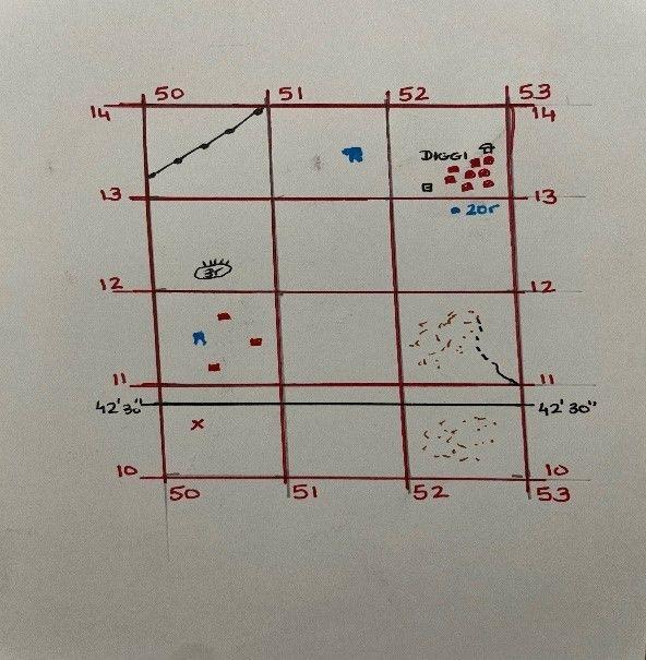
Q1. What is the red symbol in Grid 5010?
29Inhabited Settlement
Temple
Deserted settlement
Church


- Q1
Q1. What is the red symbol in Grid 5010?
Inhabited Settlement
Temple
Deserted settlement
Church
10s - Q2
Q2. What is the drainage pattern in Grid 5211
Dendritic
Undefined
Trellis
Radial
10s - Q3
Q3. What is the difference in the slope between Grid 2204 & 2003?
Both are gentle
2204 is steeper
2204 is gentler
Both are steep
10s - Q4
Q4. What is meant by 200 in 2102?
Height at that point is 200m
The contour line is at a depth of 200m
Height of the contour line is 20m
Height of the contour line is 200m
10s - Q5
Q5. What is the distance between .348 and triangulated height 384?
2 squares
2 m
2 cm
2 km
10s - Q6
Q6. What is the drainage pattern in Grid 2202?
Trellis
10s - Q7
Q7. What is meant by 10r in Grid 0113?
Relative height of the sand dune is 10km
Relative height of the sand dune is 10m
Relative height of the sand dune is 10m above MSL
Relative depth of the sand dune is 10m
10s - Q8
Q8. What is the direction of flow of the Dhola Nala?
W to E
SW to NE
SE to NW
E to W
10s - Q9
Q9. What is meant by 117 (in red) in Grid 2986?
Stone distance in metres
Distance stone in cm
Stone distance in km
Distance stone in km
10s - Q10
Q10. What are the black curved lines along the river?
Undefined land
Broken land
Broken ground
Undefined streams
10s - Q11
Q.11 Factors affecting temperature of a place situated in India.
Latitude, altitude, temperate and tropical cyclones, jet streams.
Tropic of Capricorn, hurricane, altitude, jet streams.
Typhoons, Himalayas, altitude, cyclones.
Latitude, westerlies, altitude, jet streams,
10s - Q12
Q.12 Pick out the wrong option.
Hot and dry season(March to May)
Rainy season (June to September)
Cold season (October to December)
Season of retreating south west monsoon(October to November)
10s - Q13
Q.13 The hot season ends and south west monsoon sets in with
North west trade winds blowing from northwest to south west.
The deflection of the south east trade winds on crossing the equator.
North Westerlies blowing from subtropical high to south west India.
South Westerlies blowing from sub-tropical high to south west India.
10s - Q14
14. Which two stations are likely to receive rainfall in December?
D & A
B & D
A & C
C & D
10s - Q15
15. Why doesn’t Chennai get rain from Bay of Bengal branch of SW monsoon winds?
Coromandel coast is parallelto the Bay of Bengal Branch of South West monsoon winds.
All of the above.
Eastern Ghats are parallel to the Bay of Bengal branch of South West monsoon winds.
Chennai is parallel to the Bay of Bengal branch of SW monsoon winds.
10s


