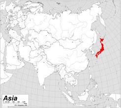
SE Asia Map Review
Quiz by Karen Sahr
Feel free to use or edit a copy
includes Teacher and Student dashboards
Measure skillsfrom any curriculum
Measure skills
from any curriculum
Tag the questions with any skills you have. Your dashboard will track each student's mastery of each skill.
With a free account, teachers can
- edit the questions
- save a copy for later
- start a class game
- automatically assign follow-up activities based on students’ scores
- assign as homework
- share a link with colleagues
- print as a bubble sheet
18 questions
Show answers
- Q1What country is this?JapanVietnamIndiaNorth Korea30s
- Q2What country is this?IndiaVietnamChinaCambodia30s
- Q3What country is this?CambodiaChinaVietnamIndia30s
- Q4What body of water is represented by the star?Arabian SeaIndian OceanBay of BengalSouth China Sea30s
- Q5What country is this?South KoreaJapanLaosNorth Korea30s
- Q6What country is this?North KoreaSouth KoreaJapanThailand30s
- Q7What body of water is represented by the star?Bay of BengalSea of JapanSouth China SeaYellow Sea30s
- Q8What river is represented by the star?Nile RiverHuang He (Yellow) RiverGanges RiverYangtze River30s
- Q9What river is represented by the star?Yangtze RiverCongo RiverHuang He (Yellow) RiverGanges River30s
- Q10What river is represented by the star?Yangtze RiverHuang He (Yellow) RiverGanges RiverNiger River30s
- Q11What physical feature is represented by the star?Himalaya MountainsTaklimakan DesertKorean PeninsulaGobi Desert30s
- Q12What physical feature is circled on the map?Gobi DesertKorean PeninsulaTaklimakan DesertHimalaya Mountains30s
- Q13What body of water is represented by the star?Yellow SeaBay of BengalSea of JapanIndian Ocean30s
- Q14What body of water is represented by the star?Sea of JapanIndian OceanSouth China SeaBay of Bengal30s
- Q15What body of water is represented by the star?Sea of JapanBay of BengalYellow SeaSouth China Sea30s
