
SEA-ATLANTIC
Quiz by Melda
Customize this quiz to suit your class
Instantly translate to 100+ languages
Tag the questions with any skills you have. Your dashboard will track each student's mastery of each skill.
Give this quiz to my class
​What's the name of Nemo's fish species?
Atlantic manta
Chinook salmon
nemofish
clownfishÂ
​What can be used for the word  “Berührungsbecken" in English?
touching pool
touchable table
swimming pool
interactive basin
What's the name of Nemo's fish species?
What can be used for the word  “Berührungsbecken" in English?
Jellyfish are sea creatures.
Order the following words in
Where do you keep fish at home?
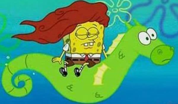
What animal is Spongebob Squarepants sitting on?

Connect the correct translations.
How do you call someone who shows you around a museum?
What is the biggest fish? Put them in a correct order. (big->small)
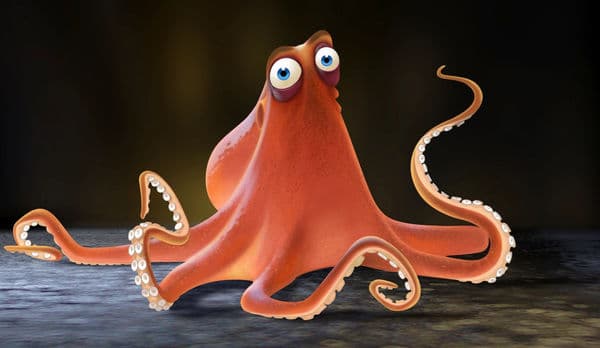
What type of sea creature is Dory's friend?

Identify and locate geographical features of Europe, including: • Alps • Influence of the North Atlantic Drift • Atlantic Ocean • North European Plain • English Channel • Ural Mountains • Mediterranean Sea
Continental Drift Theory. From the discussion of the rock cycle, it has been pointed out that through Earth's external and internal processes. Earth's surface is constantly changing. However, this idea of a changing environment did not conform with the belief of earlier scientists. Rather, they thought that the geographic positions of ocean basins and continents have been static since the beginning of time. It was around the 1500s when Leonardo da Vinci, upon his discovery of fossil seashells found at the high mountains of Italy, first thought of the idea that the areas where mountains are located may have been oceans in the past. Through time, other fossils of marine organisms found far above the current sea level further supported the idea that mountains were uplifted and weathering wore them down. At around the 1800s, most scientists have accepted the idea that Earth's crust is undergoing large vertical movements or uplifting. There was also evidence of possible horizontal movements, but the scientists then were not convinced about it. Alfred Wegener showed evidence of horizontal or lateral movement of the continents in his continental drift theory. According to him, the continents have drifted around the world and have once formed a giant landmass or supercontinent called Pangaea. To support his theory, Alfred Wegener presented a set of geographical, biological, and climatic evidence.Wegener's geographical evidence included the jigsaw puzzle fit of the current continents. He pointed out that the coastlines of South America and Africa seem to fit together. He also pointed the presence of mountain ranges having similar rock types and age but separated by vast oceans, like that of the folded rocks of the Caledonian mountains. The same folded rocks run through West Africa, North America, Newfoundland, Ireland, Wales, Scotland, Greenland, and Norway, all of which are now separated by the Atlantic Ocean. A geographical evidence on the similar rock types in West Africa, North America, Greenland, and Europe is found. The biological evidence came in the discovery of similar plant and animal fossils in different continents separated by oceans. The animal fossils of Mesosaurus and Lystrosaurus indicate that they were not capable of crossing the oceans to reach the other continents. If they were, the fossils should have been more widely distributed Africa, Australia, India, and South America were too large to be carried by wind. This indicates that the areas where the fossils were found were closely linked. It has also been found out that the plant only grew in areas with subpolar climate, which would indicate that the landmasses were located near the South Pole.Lastly, for his climatic evidence, Wegener discovered that a glacial period occurred during the late Paleozoic era in Southern Africa, South America, Australia, and India. The initial explanation for this event was global cooling, but it was rejected because large tropical swamps with so much vegetation were found at the same time in the Northern Hemisphere. This further supported the idea that the supercontinent was indeed near the South Pole, and the continents in Northern Hemisphere were once near the equator. The glacial period also left glacial striations, or the scratches glaciers make as they move across on the underlying bedrock, on the aforementioned continents. For such an event to happen, the continents would have to be connected. SCIENCE PIONEER. Alfred Wegener (1880-1930). Alfred Wegener was a German polar researcher, geophysicist, and meteorologist. He was known for his work on the continental drift theory. In his effort to defend his work, he went to the Greenland ice sheet where he died.Even with all the compelling evidence, the continental drift theory hardly convinced the scientific community at that time because Wegener was unable to identify a credible mechanism that drives the continental drift. He was unable to clearly explain how the continents moved and how the larger continents broke through the ocean floor. Eventually, critics of the continental drift began to accept the theory when new evidence supporting the theory was discovered. The new evidence led to a more encompassing theory the theory of plate tectonics. This theory provided a more convincing explanation as to how the continents moved. The evidence that paved the way for the theory of plate tectonics was the idea of wandering poles. Scientists began studying volcanic rocks to determine the location of the magnetic poles. When volcanic rocks crystallize, the minerals with magnetic properties align themselves parallel to Earth's magnetic field at the time the minerals were formed. This finding allowed scientists to determine the polarity of Earth's magnetic field and the magnetic inclination that showed the location of the poles. Upon studying the paleomagnetism of the rocks, geophysicists found out that rocks from various locations point to different magnetic north poles, suggesting that the poles have wandered. Since movement of magnetic poles is very unlikely, scientists have accepted the idea that the continents are indeed moving. And if the continents are moving, scientists thought that maybe the ocean basins are moving too. They also discovered that some rocks showed magnetic reversals, which led them to believe that the magnetic north pole now was not always the magnetic north pole. Seafloor Spreading. After World War II, exploration on the ocean floor became the focus of many geologic studies. It was only then that the ocean ridge system was discovered. A geologist in Princeton University named Harry Hess, along with other scientists, studied this ocean ridge system and hypothesized that the oceanic crust was moving away from the ridge. His hypothesis, known as seafloor spreading, showed that the ocean floor is split along the ridge where the magma rises to form the new ocean floor.Because of this, rocks located near the ridge are younger than those that are located magnetic polarity of Earth is also preserved in those rocks. Withe ridge scientists were able to see the magnetic reversals in the ocean floor, and they were able to make use of information to determine that the ocean floor is moving at a rate of about 10 cm per year. Plate Tectonics. Confirmation of the seafloor spreading hypothesis proved that continents are not moving above the ocean floor. Rather, it is the fragments of the lithosphere. The lithosphere is the rigid layer that is composed of the uppermost mantle and the crust that carry the continents and the ocean basins along. These fragments of the lithosphere are called plates. Underneath the lithosphere is a weaker region in the mantle known as asthenosphere that behaves like a fluid. Thus, the lithosphere floats above the asthenosphere, making it detached and free to move. This became the basis of the theory of plate tectonics. Now that it has been made clear that it is the plates which are moving, the question as to how they move remained. Sir Arthur Holmes proposed the driving force for this plate movement in 1919. He suggested that the movement in the mantle carries the plates along. It was previously discussed that Earth's interior is very hot due to the heat produced by radioactive decay. Convection takes place in the mantle, keeping the asthenosphere hot and weak. The convection currents produced in the asthenosphere are the ones carrying the lithospheric plates and making them move. However, convection currents are not enough. Mechanisms such as ridge push and slab pull aid the convection currents to slowly move the lithospheric plates. Ridge push occurs at mid ocean ridges which are higher in elevation than the surrounding trenches and abyssal plains. The new ocean floor from the ridge is hot and relatively thin. As it moves away from the ridge, it cools down and gets denser, heavier, and thicker. Below this cooling ocean floor is the asthenosphere, which is less dense. This area becomes a massive shear zone and the new ocean floor will effectively slide down the slope of the asthenosphere. When the plate collides with another plate with lesser density, the denser plate sinks and a subduction zone is formed. When the subducting plate sinks, it pulls on the rest of the plate behind it. These mechanisms explain the movement of the plates.Earth has seven major lithospheric plates that account for 94% of Earth's surface. These are the North American Plate, South American Plate, Pacific Plate, African Plate, Eurasian Plate, Indo-Australian Plate, and Antarctic Plate. These plates are constantly moving relative to the other plates. Thus, the interaction of plates occurs mostly along the boundaries. These movements are plotted using information from earthquakes and volcanic activities. There are three main types of plate boundaries: convergent, divergent, and transform boundaries Convergent boundaries are boundaries where two plates move towards each other A convergent boundary is also known as destructive margin since this is where the collision between two plates occhins. There are three types of convergence-oceanic oceanic, oceanic-continental, and continental-continental. Trenches are features of the ocean floor that are present in both oceanic-oceanic boundary and oceanic-continental boundary. Subduction occurs at the trenches, therefore, these are characterized as the deepest parts of Earth. A divergent boundary is the opposite of convergent boundary: two plates move away from each other. Divergent boundaries create new crust; thus, they are also known as constructive margins. The ocean ridge system is a divergent boundary where new ocean floor is produced as magma rises, pushing the older rocks aside.Transform boundary is also known as conservative plate margin since two plates just move past one another, neither creating nor destroying land. Earthquake epicenters are usually detected at transform boundaries because the rocks tend to break and not fold or sink, like in convergent boundaries. Evolution of the Ocean Basins. Both the movement of the plates and seafloor are responsible for the evolution of ocean basins. Along the divergent boundary where ocean ridge systems are found, magma is released and new ocean floor is created. Along convergent boundaries, the ocean floor is being destroyed. The evolution of the ocean basins started during the time when Pangaea was still present and was surrounded by the vast ocean or superocean known as Panthalassa, also called Paleo-Pacific or "old Pacific." Upon the initial break up of Pangaea into Laurasia and Gondwanaland, the Tethys Sea began to form. Then, the Eurasian and North about, forming the North Atlantic. The South Atlantic only started to form when the African Plate and South American Plate separated. The continued movement of the plates created the Himalayas at one side and separated the Pacific Ocean and Atlantic Ocean at the other side, which consequently formed the current ocean basins. Both the movement of the plates and seafloor are responsible for the evolution of ocean basins. Along the divergent boundary where ocean ridge systems are found, magma is released and new ocean floor is created. Along convergent boundaries, the ocean floor is being destroyed. The evolution of the ocean basins started during the time when Pangaea was still present and was surrounded by the vast ocean or superocean known as Panthalassa, also called Paleo-Pacific or "old Pacific." Upon the initial break up of Pangaea into Laurasia and Gondwanaland, the Tethys Sea began to form. Then, the Eurasian and North about, forming the North Atlantic. The South Atlantic only started to form when the African Plate and South American Plate separated. The continued movement of the plates created the Himalayas at one side and separated the Pacific Ocean and Atlantic Ocean at the other side, which consequently formed the current ocean basins.Continents do not immediately end at the point where the ocean meets the land. They may extend slightly into the oceans. The portion of the continent that is submerged is called continental margin. There are two types of continental margin: passive margin and active margin. A passive continental margin consists of a continental shelf, continental slope, and continental rise. It is not associated with plate boundaries; thus, there are very little tectonic activities. An active continental margin only has a continental shelf and a continental slope. It is associated with plate boundaries; thus, a main feature of this boundary is a trench. The different features of a continental margin are the following: 1. The continental shelf is the gently-sloping submerged portion of the continent. 2. The continental slope is the steep slope after the continental shelf. It is still part of the continent. 3. The continental rise is the gently-sloping area after the continental slope and before the ocean floor. 4. The trenches are the deepest parts of the ocean. These are narrow depressions caused by the subduction of the ocean floor along the convergent boundaries. 5. The mid-oceanic ridge is the mountain range system in the ocean. It is responsible for the production of new ocean floor. This is the region where new magma constantly emerges from. SCIENCE CAREER. A scientific illustrator uses art to inform and communicate complex details and concepts of science. He/She makes use of scientifically informed observations and research along with his/her technical art and aesthetic skills to make accurate representations. In Natural History, the scientific illustrators recreate how the extinct species look like by working with scientists and fossil records. Moreover, with the advances in technology, illustrators are now into 3D modelling, animation, and video making. Earth's History. All the processes that have been discussed require long periods of time to create a noticeable change on Earth's surface. You can just imagine how long it would take to create an oceanas vast as the Pacific Ocean if the ocean floor moves only at about 10 cm/year. It is then important to know the history of Earth to learn the complexities of its past and be able to use it to understand the present. Just like learning the history of a country that requires one to read a lot of books, learning the history of Earth involves studying a lot of rocks. Rocks, especially sedimentary rocks, contain a lot of information about Earth's past. It holds the key to most of the geologic processes that happened on Earth and the key to uncovering how life on Earth evolved. But these discoveries are worthless if there is no time perspective. Thus, one of the most important contributions of geologists to mankind is the geologic time scale, which holds a history that is exceedingly long.
Sarah is a 19-year-old woman who sailed solo around the world in just one year. Listen to the following excerpts from her taped journal as she sailed. January 10th: I left the island of Jamaica yesterday, and now I’m on my way to the Panama Canal. I’m excited, because I never tried to sail around the world alone before. February 23rd: I arrived at the Galapagos Islands today. It’s my first time here. There are so many amazing animals to see on these islands – sea lions, iguanas, and the Galapagos tortoise. August 15th: I am now in Darwin, Australia – at the northern point of this country. Sailing here was quite good, but sometimes the ocean was very rough. November 7th: I’m now in South Africa, in Port Elizabeth. Many people welcomed me when I came into port. I’m happy, but I still have to cross the Atlantic Ocean. December 30th: I can see the city of Kingston in the distance. There are many boats around me, and people are congratulating me. I did it! I met my goal! I sailed around the world in less than a year.
Contact with the Americas In 1001, Viking sailors led by Leif Erikson reached the eastern tip of North America. Archaeologists have found evidence of the Viking settlement of Vinland in present-day Newfoundland, Canada. The Vikings did not stay in Vinland long and no one is sure why they left. However, Viking stories describe fierce battles with Skraelings, the Viking name for the Inuit. Evidence suggests that Asians continued to cross the Bering Sea into North America after the last ice age ended. Some scholars believe that ancient seafarers from Polynesia may have traveled to the Americas using their knowledge of the stars and winds. Modern Polynesians have sailed canoes thousands of miles in this way. Still others think that fishing boats from China and Japan blew off course and landed on the western coast of North or South America. Perhaps such voyages occurred. If so, they were long forgotten. Before 1492, the peoples of Asia and Europe had no knowledge of the Americas and their remarkable civilizations. The Voyages of Columbus Portuguese sailors had pioneered new routes around Africa toward Asia in the late 1400s. Spain, too, wanted a share of the riches. King Ferdinand and Queen Isabella hoped to keep their rival, Portugal, from controlling trade with India, China, and Japan. They agreed to finance a voyage of exploration by Christopher Columbus. Columbus, an Italian sea captain, planned to reach the East Indies by sailing west across the Atlantic. Finding a sea route straight to Asia would give the Spanish direct access to the silks, spices, and precious metals of Asia. The spice trade was a major cause for European exploration and a reason the Spanish rulers supported Columbus’s voyage. They also wanted wealth from any source. “Get gold,” King Ferdinand said to Columbus. “Humanely if possible, but at all hazards—get gold.” Crossing the Atlantic In August 1492, Columbus set out with three ships and about 90 sailors. As captain, he commanded the largest vessel, the Santa MarĂa. The other ships were the Niña and the Pinta. After a brief stop at the Canary Islands, the little fleet continued west into unknown seas. Fair winds sped them along, but a month passed without the sight of land. Some sailors began to grumble. They had never been away from land for so long and feared being lost at sea. Still, Columbus sailed on. On October 7, sailors saw flocks of birds flying southwest. Columbus changed course to follow the birds. A few days later, crew members spotted tree branches and flowers floating in the water. At 2 a.m. on October 12, the lookout on the Pinta spotted white cliffs shining in the moonlight. “Tierra! Tierra!” he shouted. “Land! Land!” At dawn, Columbus rowed ashore and planted the banner of Spain. He was convinced that he had reached the East Indies in Asia. He called the people he found there “Indians.” In fact, he had reached islands off the coasts of North America and South America in the Caribbean Sea. These islands later became known as the West Indies. For three months, Columbus explored the West Indies. To his delight, he found signs of gold on the islands. Eager to report his success, he returned to Spain. Columbus Claims Lands for Spain In Spain, Columbus presented Queen Isabella and King Ferdinand with gifts of pink pearls and brilliantly colored parrots. Columbus brought with him many things that Europeans had never seen before: tobacco, pineapples, and hammocks used for sleeping. Columbus also described the “Indians” he had met, the Taino (ty noh). The Taino, he promised, could easily be converted to Christianity and could also be used as slaves. The Spanish monarchs were impressed. They gave Columbus the title Admiral of the Ocean Sea. They also agreed to finance future voyages. The promise of great wealth, and the chance to spread Christianity, gave them a reason to explore further. Columbus made three more voyages across the Atlantic. In 1493, he founded the first Spanish colony in the Americas, Santo Domingo, on an island he called Hispaniola (present-day Haiti and the Dominican Republic). A colony is an area settled and ruled by the government of a distant land. Columbus also explored present-day Cuba and Jamaica. He sailed along the coasts of Central America and northern South America. He claimed all of these lands for Queen Isabella of Spain. Columbus proved to be a better explorer than governor. During his third expedition, settlers on Hispaniola complained of his harsh rule. Queen Isabella appointed an investigator, who sent Columbus back to Spain in chains. In the end, the queen pardoned Columbus, but he never regained the honors he had won earlier. He died in 1506, still convinced that he had reached Asia. The Impact of Columbus’s Voyages Columbus has long been honored as the bold sea captain who “discovered America.” Today, we recognize that American Indians had discovered and settled these lands long before 1492. We also recognize that Columbus and the Europeans who followed him treated the ancient inhabitants of the Americas brutally. Still, Columbus’s voyages did change history. They marked the beginning of lasting contact among the peoples of Europe, Africa, and the Americas. For a great many American Indians, contact had tragic results. Columbus and those who followed were convinced that European culture was superior to that of the Indians. The Spanish claimed Taino lands and forced the Taino to work in gold mines, on ranches, or in Spanish households. Many Taino died from harsh conditions or European diseases. The Taino population was wiped out. Still, the voyages of Columbus signaled a turning point for the Americas. A turning point is a moment in history that marks a decisive change. Curious Europeans saw the new lands as a place where they could settle, trade, and grow rich. Spanish Exploration Continues After the voyages of Columbus, the Spanish explored and settled other Caribbean islands that Columbus had found. They sought gold, land for crops, people to enslave, and converts to Christianity for the Spanish crown. By 1511, they had conquered Puerto Rico, Jamaica, and Cuba. They also explored the eastern coasts of North America and South America in search of a western route to Asia. In 1513, Vasco Núñez de Balboa (bal boh uh) crossed the Isthmus of Panama. American Indians had told him that a large body of water lay to the west. With a party of Spanish soldiers and Indians, Balboa reached the Pacific Ocean and claimed the ocean for Spain. The Spanish had no idea how wide the Pacific was until a sea captain named Ferdinand Magellan (muh jel un) sailed across it. The expedition—made up of five ships and about 250 crew members—left Spain in 1519. Fifteen months later, it cut through the stormy southern tip of South America by way of what is now known as the Strait of Magellan and entered the Pacific Ocean. Crossing the vast Pacific, the sailors ran out of food: Primary Source “We remained 3 months and 20 days without taking in provisions or other refreshments and ate only old biscuit reduced to powder, full of grubs and stinking from the dirt which rats had made on it. We drank water that was yellow and stinking.” —Antonio Pigafetta, The Diary of Antonio Pigafetta Magellan himself was killed in a battle with the local people of the Philippine Islands off the coast of Asia. In 1522, only one ship and 18 sailors returned to Spain. They were the first people to circumnavigate, or sail completely around, the world. In doing so, they had found an all-water western route to Asia. Europeans became aware of the true size of the Earth. How Did the Columbian Exchange Affect the Rest of the World? The encounter between the peoples of the Eastern and Western Hemispheres sparked a global exchange of goods and ideas. Because it started with the voyages of Columbus, this transfer is known as the Columbian Exchange. The Columbian Exchange refers to a biological and cultural exchange of animals, plants, human populations, diseases, food, government, technology, the arts, and languages. The exchange went in both directions. Europeans learned much from American Indians. At the same time, Europeans contributed in many ways to the culture of the Americas. This exchange also brought about many modifications, or changes, to the physical environment of the Americas, with both positive and negative results. Changing Environments Europeans introduced domestic animals such as chickens from Europe and Africa. European pigs, cattle, and horses often escaped into the wild and multiplied rapidly. Forests and grasslands were converted to pastures. As horses spread through what would become the United States, Indians learned to ride them and used them to carry heavy loads. Plants from Europe and Africa changed the way American Indians lived. The first bananas came from the Canary Islands. By 1520, one Spaniard reported that banana trees had spread “so greatly that it is marvelous to see the great abundance of them.” Oranges, lemons, and figs were also new to the Americas. In North America, explorers also brought such plants as bluegrass, the daisy, and the dandelion. These plants spread quickly in American soil and modified American grasslands. Tragically, Europeans also brought new diseases, such as smallpox and influenza. American Indians had no resistance to these diseases. Historians estimate that within 75 years, diseases from Europe had killed almost 90 percent of the people in the Caribbean Islands and in Mexico. American Indian Influences on Europe, Africa and Asia American Indians introduced Europeans to valuable food crops such as corn, potatoes, sweet potatoes, beans, tomatoes, manioc, squash, peanuts, pineapples, and blueberries. Today, almost half the world’s food crops come from plants that were first grown in the Americas. Europeans carried the new foods with them as they sailed around the world. Everywhere, people’s diets changed and populations increased. In South Asia, people used American hot peppers and chilies to spice stews. Chinese peasants began growing corn and sweet potatoes. Italians made sauces from tomatoes. People in West Africa grew manioc and corn. European settlers often adopted American Indian skills. In the North, Indians showed Europeans how to use snowshoes and trap beavers and other fur-bearing animals. European explorers learned how to paddle Indian canoes. Some leaders studied American Indian political structures. In the 1700s, Benjamin Franklin admired the Iroquois League and urged American colonists to unite in a similar way. Positive and Negative Consequences Through the Columbian Exchange, Europeans and American Indians modified their environments and gained new resources and skills. At the same time, warfare and disease killed many on both sides. Europeans viewed expansion positively. They gained great wealth, explored trade routes, and spread Christianity. Yet their farming, mining, and diseases took a toll on the physical environment and left many American Indians dead. Despite these negatives, the Columbian Exchange shaped the modern world, including what would become the United States.
SEA
Sea animals
SEA Practice Week 15 Day 3
Sea Chimneys Bell Ringer ELA.7.R.C2.4