TEKS Social Studies Grade 8 - Topic: 8.10-8.11 Geography
Quiz by TEKS Social Studies Grade 8
Grade 8
Social Studies K-HS (Archived)
Texas Essential Knowledge and Skills (TEKS)
Feel free to use or edit a copy
includes Teacher and Student dashboards
Measures 6 skills from
Measures 6 skills from
Track each student's skills and progress in your Mastery dashboards
With a free account, teachers can
- edit the questions
- save a copy for later
- start a class game
- automatically assign follow-up activities based on students’ scores
- assign as homework
- share a link with colleagues
- print as a bubble sheet
21 questions
Show answers
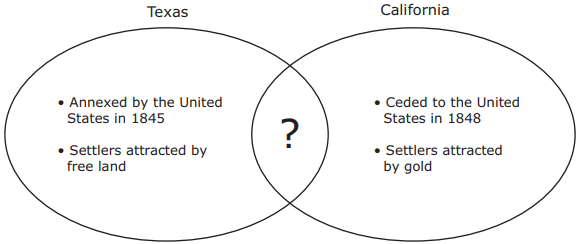
- Q1Which of the following best completes the diagram above?Dependent on heavy industryBordered by the PacificFormerly part of MexicoSlaveholding state60s8.10.B: Social Studies - Geography
- Q2According to the excerpt above, the Gadsden Purchase was intended to —support settlement of U.S. territory gained through the U.S.-Mexican Warencourage the sale of U.S. government land in Floridaencourage commerce among U.S. states formed from the Louisiana Purchaseallow the United States and Mexico to share railroad construction costs60s8.11.A: Social Studies - Geography
- Q3One advantage the Confederacy had over the Union during the Civil War was that Confederate forces had —a larger number of military troops in reserveknowledge of the terrain where most battles were foughtan extensive railroad system for moving troops and suppliesnumerous factories for producing weapons and ammunition60s8.10.C: Social Studies - Geography
- Q4What effect did the mining technique described in this excerpt have on the local environment?Reduced flooding led to an increased reliance on irrigation.Forests were clear-cut, and the timber was used to line tunnels and shafts.Farmland benefited from a change in soil composition.Rivers became filled with sediment.60s8.11.B: Social Studies - Geography
- Q5Which characteristic is correctly matched with a number in the table?1: Indigo4: Ships3: Rocky soil2: Moderate60s8.11.A: Social Studies - Geography
- Q6The numbered river on this map played a major role in —the exploration of new territory acquired from Francethe settlement of territory previously claimed by the Dutchthe defeat of British invaders at the Battle of Fort McHenrythe defeat of British troops at the Battle of Saratoga60s8.10.C: Social Studies - Geography
- Q7Which of the following was the most direct result of the environmental modifications listed above?Road construction became a major industry in the United States.Federal regulations were adopted to ensure safety and ease of travel on the road.Improved transportation to western states expanded trade and settlement.State governments cooperated closely to maintain road quality.60s8.11.B: Social Studies - Geography
- Q8Boston and New Orleans were both founded as —military outpostsindustrial centersfarming communitiesport cities60s8.10.B: Social Studies - Geography
- Q9Which factor encouraged more immigrants to settle in northern states than southern states during the mid-nineteenth century?Governments in northern states were less corrupt.Northern states had lower population densities.Southern states had smaller industrial sectors.Citizenship requirements in southern states were not as strict.60s8.10.B: Social Studies - Geography
- Q10The completion of the Erie Canal played a key role in which development?New York City becoming a vital commercial center with the country’s busiest seaportWashington, D.C., becoming the cultural and political center of the nationNew Orleans becoming a leader in manufacturing and overseas tradeBoston becoming one of the country’s largest transportation hubs60s8.10.C: Social Studies - Geography
- Q11One environmental consequence of the large-scale cultivation of cotton in the South was —drought caused by overuse of river water to irrigate farmlandwidespread water contamination caused by fertilizer runoffwidespread soil exhaustion caused by decades of farmingair pollution caused by the use of cotton gins60s8.11.B: Social Studies - Geography
- Q12What was the result of the events shown on the map above?General Grant’s supply lines were completely cut off.General Grant and General Lee combined forces.General Lee’s troops received necessary reinforcements.General Lee surrendered to General Grant.60s8.10.A: Social Studies - Geography
- Q13Which of the following best replaces the question mark in the diagram above?Settled by MormonsDependent on slaveryLarge coal depositsFormer Mexican territory60s8.10.B: Social Studies - Geography
- Q14How did geography influence the early economic development of New York, Boston, and Charleston?Long coastlines offered abundant natural resources.Extreme climates limited productive activity.Natural harbors provided access to markets.Proximity to flooding rivers limited development.60s8.10.B: Social Studies - Geography
- Q15A tourist would most likely go to the location shown on the map to visit —Historic Jamestowne in Colonial National Historical ParkIndependence Hall in Independence National Historical ParkGeorge Washington’s Headquarters in Valley Forge National Historical Parkthe Elizabeth Cady Stanton House in Women’s Rights National Historical Park60s8.10.A: Social Studies - Geography
