Feel free to use or edit a copy
includes Teacher and Student dashboards
Measure skillsfrom any curriculum
Measure skills
from any curriculum
Tag the questions with any skills you have. Your dashboard will track each student's mastery of each skill.
With a free account, teachers can
- edit the questions
- save a copy for later
- start a class game
- automatically assign follow-up activities based on students’ scores
- assign as homework
- share a link with colleagues
- print as a bubble sheet
15 questions
Show answers
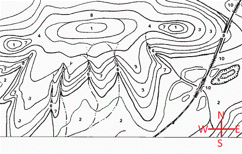
- Q1What is indicated by the number 6's in the picture?A hole/depressionFlat landA hill/mountainA river30s
- Q2Which direction are the rivers flowing?NorthEastSouthWest30s
- Q3What is the approximate relief of Coe Creek from Point D to Point G?10020022032030s
- Q4What is the approximate relief from Point D to Point C?1502001005030s
- Q5What does number 1 look like from the side?BFAD30s
- Q6What does number 5 look like from the side?FADB30s
- Q7What does number 3 look like from the side?FACE30s
- Q8What is the highest elevation on the mainland?10050706030s
- Q9What is the highest elevation on the small island in the west?501020030s
- Q10A person wants to hike this mountain by taking the easiest path with the gentlest slope to the top, point X. Which path should they take?Path CPath APath DPath B30s
- Q11Which path to point X is the steepest path?Path DPath BPath APath C30s
- Q12What is the elevation of point X?95075050085030s
- Q13What is the relief from the top of the mountain to point X?20030030325330s
- Q14How many mountain peaks are shown on this map?423130s
- Q15What is the best approximate elevation of point F?18017016020030s

