Trace the path of typhoons that enter PAR SELF ASSSESSMENT
Quiz by Angelica Tamang
Feel free to use or edit a copy
includes Teacher and Student dashboards
Measure skillsfrom any curriculum
Tag the questions with any skills you have. Your dashboard will track each student's mastery of each skill.
- edit the questions
- save a copy for later
- start a class game
- automatically assign follow-up activities based on students’ scores
- assign as homework
- share a link with colleagues
- print as a bubble sheet
- Q1
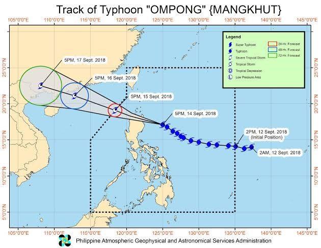
Please refer to the picture of Track of Typhoon OMPONG and answer the question below.
On what day and time is Typhoon Ompong expected to enter the PAR?
2 AM, 12 Sept. 2018
2 PM, 12 Sept. 2018
5 PM,15 Sept. 2018
5 PM, 14 Sept. 2018
60s - Q2
What can we conclude based on the track of Typhoon Ompong?
It will stay only on water.
It will make a land fall at the northern tip of the Philippines.
It will not make a land fall on any part of the Philippines.
It will stay only on land.
60s - Q3
Which of the following statements best describes Philippine Area of Responsibility?
It is an area in Northwest Pacific region where PAGASA observes tropical cyclones.
It is an agency that monitors and tracks tropical cyclone.
It tells where the territories of the Philippines are.
It is an area inside the Philippine that frequently encounters weather disturbances.
60s - Q4
Why are Public Storm Warning Signals in a certain place changes from time to time?
Wind speed of the tropical cyclones makes the warning signals become higher.
Warning signals are based on the place affected by the typhoons.
People becomes more prepared over time that downgrades the signal number.
Tropical cyclones are moving thus locality being affected also changes.
60s
