

Unit 1 Review
Quiz by Megan Thompson
Feel free to use or edit a copy
includes Teacher and Student dashboards
Measure skillsfrom any curriculum
Measure skills
from any curriculum
Tag the questions with any skills you have. Your dashboard will track each student's mastery of each skill.
With a free account, teachers can
- edit the questions
- save a copy for later
- start a class game
- automatically assign follow-up activities based on students’ scores
- assign as homework
- share a link with colleagues
- print as a bubble sheet
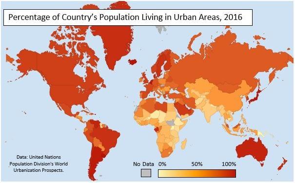
- Q 1/14Score 0What type of map is being shown here?29ChoroplethCartogramProportional SymbolIsoline


14 questions
Show answers
- Q1What type of map is being shown here?ChoroplethCartogramProportional SymbolIsoline30s
- Q2The circulation area of a newspaper is aFormal RegionFunctional RegionVernacular Region30s
- Q3The concept that the physical environment limits human actions, but that people have the ability to adjust to the physical environment isEnvironmental DeterminismCultural EcologyPossibilismCultural Relativism30s
- Q4Which of the following do geographers use to compare a variety of spatial data by creating digitized representations of the environment by combining layers of spatial data, and creating maps in which patterns and processes are superimposed?Mental MapsGPSRemote SensingGIS30s
- Q5The French-speaking region of Europe is what type of region?Formal RegionVernacular RegionFunctional Region30s
- Q6The declining degree of acceptance of an idea or innovation with increasing time and distance from its point of origin or source is calledHierarchical DiffusionSpace Time CompressionDistance DecayCultural Hearth30s
- Q7Using lines of latitude and longitude to find an exact location isSiteAbsolute locationSituationRealtive location30s
- Q8What scale of analysis is being used here?Sub-national/localRegionalNationalGlobal30s
- Q9What scale of analysis is being used here?GlobalSub-national/localRegionalNational30s
- Q10What type of map is this?CartogramChoroplethProportioanl SymbolIsoline30s
- Q11A climatologist who used aerial photos to measure the shrinking of glaciers is using which of the following?Digital GlobesRemote SensingGISGPS30s
- Q12Belief that the physical geography and climate have the ultimate determining factor over the success or failure of humans in regionsEnvironmental DeterminismSpace Time CompressionCultural RelativismPossibilism30s
- Q13Which of the following has allowed for the greatest space-time compressionthe invention of the internetinvention of the automobiledomesticating horsesinvention of horse drawn carriages30s
- Q14A type of map that uses lines to connect points of equal value is a(n)IsolineCartogramProportional SymbolChoropleth30s


