Unit Assessment #3 (Earth Science)
Quiz by Sara Leigh-Manuell
Feel free to use or edit a copy
includes Teacher and Student dashboards
Measure skillsfrom any curriculum
Measure skills
from any curriculum
Tag the questions with any skills you have. Your dashboard will track each student's mastery of each skill.
With a free account, teachers can
- edit the questions
- save a copy for later
- start a class game
- automatically assign follow-up activities based on students’ scores
- assign as homework
- share a link with colleagues
- print as a bubble sheet


16 questions
Show answers
- Q1Both of these activities increase erosionconstruction and farming30s
- Q2cracking (breaking ) of rocks into smaller piecesweathering30s
- Q3This is the transport (movement) of earth materials. It increases when the slopes are steep! It is a DESTRUCTIVE force.erosion30s
- Q4land along river channels that contain a lot of fertile soilfloodplain30s
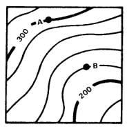
- Q5change in elevation between two linescontour interval30s
- Q6These landforms are created as a result of erosioncanyons30s
- Q7These landforms are created as a result of depositiondeltas30s
- Q8This process happens AFTER erosion. Sediments stop being moved and are left in a new location.deposition30s
- Q9When the lines on a topographic map are very close together it forms this.steep slope30s
- Q10When the lines on a topographic map are very far apart, it forms this.gentle (flat) slope30s
- Q11This type of hill will erode FASTER than a grassy hillside.bare hillside30s
- Q12What is the contour interval?20 meters5 meters100 meters10 meters30s
- Q13What is the elevation of point B?200 meters150 meters220 meters400 meters30s
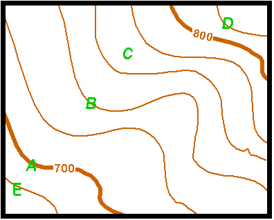
- Q14What is the contour interval?20 meters100 meters10 meters40 meters30s
- Q15Which side of the topographic map is the STEEPEST?North sideThe west sideEast SideSouth side30s