Tag the questions with any skills you have. Your dashboard will track each student's mastery of each skill.
Give this quiz to my class
Q 1/10
Score 0
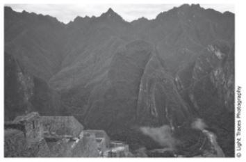
(8.9B) The photograph shows mountains in the Andes range in South America. Which statement describes the geologic process that is most likely responsible for the formation of these mountains?
60
They are along transform plate boundary in which plates are currently moving side by side causing earthquakes and faults.
They are along a plate boundary in which plates are currently converging, causing uplift and steep slopes.
They are along transform plate boundary that is no longer active, so erosion is creating deep valleys.
They are along a plate boundary in which plates diverged in the distant past allowing new rock to build up.
Q 2/10
Score 0
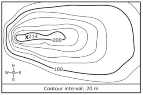
(8.9C) This topographic map represents the elevation of an area 100 years ago. At that time the highest point had an elevation of 214 m. The highest point has since eroded a total of 7 m. Which profile most likely represents the landscape today?
120
10 questions
Q.
(8.9B) The photograph shows mountains in the Andes range in South America. Which statement describes the geologic process that is most likely responsible for the formation of these mountains?
1
60 sec
Q.
(8.9C) This topographic map represents the elevation of an area 100 years ago. At that time the highest point had an elevation of 214 m. The highest point has since eroded a total of 7 m. Which profile most likely represents the landscape today?
2
120 sec
Q.
(7.8C) Water flowing over soil composed of sand and gravel will most likely -
3
120 sec
Q.
(8.9B) Strong earthquakes are unlikely to occur in Conneticut because the state is located too -
4
60 sec
Q.
(8.9C) This satellite photograph shows an area in Alaska after a fire occured. Which statement best describes the most likely effect the fire had on the river in the 12 months after it occured?
5
60 sec
Q.
(8.9B) When tectonic plates move, rocks in the crust are pushed and pulled. If the rocks are unable to move, stress on the rocks builds up. This leads to an earthquake if the rocks-
6
60 sec
Q.
(8.9C) Looking at the topographical, in what direction is the water runoff flowing?
7
60 sec
Q.
(8.9C) Which is the steepest slope?
8
60 sec
Q.
(7.8B, 8.9C) The profile is a cross section of 2 valleys that were formed by erosion. What most likely caused the erosion that formed Valley B?
9
60 sec
Q.
(8.9B) A mid-ocean ridge is located at the boundary of two tectonic plates. Which diagram correctly models the relative plate motion on each side of a mid-ocean ridge?