Tag the questions with any skills you have. Your dashboard will track each student's mastery of each skill.
Give this quiz to my class
Q 1/104
Score 0
A (1-10) scale that gives a measure of the quality of an ecosystem by the presence and abundance of species living in it; Involves levels of tolerance, diversity and abundance of organisms
30
Users re-arrange answers into correct order
Q 2/104
Score 0
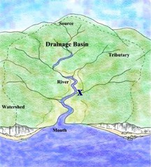
The entire geographical area drained by a river and its tributaries
30
Users re-arrange answers into correct order
104 questions
Q.
A (1-10) scale that gives a measure of the quality of an ecosystem by the presence and abundance of species living in it; Involves levels of tolerance, diversity and abundance of organisms
1
30 sec
Q.
The entire geographical area drained by a river and its tributaries
2
30 sec
Q.
The source of a river (A)
3
30 sec
Q.
A stream or river that flows into a larger river
4
30 sec
Q.
the area from which a single stream or river and its tributaries drains all of the water
5
30 sec
Q.
The bed of a stream or river
6
30 sec
Q.
a rate of inclination; a slope
7
30 sec
Q.
Small particles of dirt, rock, and sand suspended in water
8
30 sec
Q.
any body of flowing water confined within a channel, regardless of size
9
30 sec
Q.
A fan-shaped deposit of sediment formed when a stream's slope is abruptly reduced
10
30 sec
Q.
A low plain adjacent to a river that is formed chiefly of river sediment and is subject to flooding
11
30 sec
Q.
A wall built along a river bank to prevent flooding
12
30 sec
Q.
A looplike bend in the course of a river
13
30 sec
Q.
A crescent-shaped lake (often temporary) that is formed when a meander of a river is cut off from the main channel
14
30 sec
Q.
An area along which rivers form waterfalls or rapids as the rivers drop to lower land.
15
30 sec
Q.
A land area that is covered with a shallow layer of water during some or all of the year
16
30 sec
Q.
Sea of reeds
17
30 sec
Q.
An area of low, spongy land too wet to farm but usually supporting an abundance of coarse grasses, trees, or other vegetation.
18
30 sec
Q.
A device that determines the distance of an object under water by recording echoes of sound waves
19
30 sec
Q.
Study of the Ocean
20
30 sec
Q.
boundary between continental land deep ocean basins
21
30 sec
Q.
The deepest part of the ocean floor; made up of rolling hills and flat plains.
22
30 sec
Q.
this gently sloping plain forms an apron of shallow water along the edge of most continents
23
30 sec
Q.
a steep incline of the ocean floor leading down from the edge of the continental shelf
24
30 sec
Q.
the gently sloping surface at the base of the continental slope
25
30 sec
Q.
An underwater mountain chain where new ocean floor is formed
26
30 sec
Q.
A large, flat, almost level area of the deep-ocean basin
27
30 sec
Q.
Deep valley in the ocean floor that forms along a subduction zone
28
30 sec
Q.
A deep valley that forms where two plates move apart
29
30 sec
Q.
A mountain on the ocean floor that is completely underwater
30
30 sec
Q.
A large, flat-topped seamount resulting from erosion of an island volcano when it was above sea level.
31
30 sec
Q.
...
32
30 sec
Q.
See image
33
30 sec
Q.
In water, a distinctive temperature transition zone that separates an upper layer that is mixed by wind and a colder, deep layer that is not mixed
34
30 sec
Q.
measurement system used to indicate the concentration of hydrogen ions (H+) in solution; ranges from 0 to 14
35
30 sec
Q.
A horizontal movement of ocean water that is caused by wind and that occurs at or near the ocean's surface
36
30 sec
Q.
an oceanic circulation pattern that drives the mixing of surface water and deep water
37
30 sec
Q.
The apparent curving of the path of a moving object from an otherwise straight path due to the earth's rotation
38
30 sec
Q.
Highest point of a wave
39
30 sec
Q.
Lowest point of a wave
40
30 sec
Q.
The distance that the wind has traveled across open water
41
30 sec
Q.
Change in direction of a wave when it changes speed as in travels from one material to another.
42
30 sec
Q.
a subsurface current that is near shore and that pulls objects out to sea
43
30 sec
Q.
A rush of water that flows rapidly back to sea through a narrow opening
44
30 sec
Q.
Shorelines are dynamic interfaces, constantly undergoing erosion and sediment deposition
45
30 sec
Q.
implementing man made methods or structures to stop or slow the erosion of beaches
46
30 sec
Q.
A water current that travels near and parallel to the shoreline
47
30 sec
Q.
A type of movement of water in which, rather than moving downstream, the water moves every which way.
48
30 sec
Q.
an arch formed by wave erosion when caves on opposite sides of a headland unite
49
30 sec
Q.
A ridge of sand that connects an island to the mainland or to another island
50
30 sec
Q.
A ridge of sand deposited by waves as they slow down near shore.
51
30 sec
Q.
A wall made of rocks or concrete that is built outward from a beach to reduce erosion
52
30 sec
Q.
A structure that projects into the water and protects the shore
53
30 sec
Q.
a barrier constructed to prevent waves from reaching the area behind the wall. Its purpose is to defend property from the force of breaking waves.
54
30 sec
Q.
A pressurized groundwater system, including an impermeable base layer, and a cap rock.
55
30 sec
Q.
A high land area that separates one watershed from another.
56
30 sec
Q.
Process by which lakes becomes rich in nutrients from the surrounding watershed, resulting in a change in the kinds of organisms in the lake.
57
30 sec
Q.
When a stream actively resumes the process of down-cutting toward its base level.
58
30 sec
Q.
Permeable underground layer through which groundwater flows relatively easily.
59
30 sec
Q.
Describes sediments that are too heavy or large to be kept in suspension or solution and are pushed or rolled along the bottom of a stream bed.
60
30 sec
Q.
Triangular deposit, usually made up of silt and clay particles, that forms where a stream enters a large body of water.
61
30 sec
Q.
Measure of a volume of stream water that flows over a specific location in a particular amount of time.
62
30 sec
Q.
Broad, flat, fertile area extending out from a stream's bank that is covered with water during floods.
63
30 sec
Q.
Irregular topography with sinkholes, sinks, and sinking streams caused by groundwater dissolution of limestone.
64
30 sec
Q.
A difference in wave speed causes initially straight wave crests to bend when part of the crest moves into shallow water
65
30 sec
Q.
Long ridge of sand or other sediment deposited or shaped by longshore currents that is separated from the mainland and can be up to tens of kilometers long.
66
30 sec
Q.
Movement of ocean water that occurs in depths too great to be affected by surface winds and is generated by differences in water temperature and salinity.
67
30 sec
Q.
Coastal area of brackish water formed where the lower end of a freshwater river or stream enters the ocean; provides an excellent source of food and shelter to commercially important marine organisms.
68
30 sec
Q.
Measure of the amount salts dissolved in seawater, which is 35 ppt on average.
69
30 sec
Q.
Plots changing ocean water temperatures with depth, which varies, depending on location and season.
70
30 sec
Q.
Rapidly flowing ocean current that can cut deep-sea canyons in continental slopes and deposit the sediments in the form of continental rise.
71
30 sec
Q.
The continuous circulation of water among the atmosphere, the oceans, and the earth.
72
30 sec
Q.
Liquid to gas
73
30 sec
Q.
the emission of water vapor from the leaves of plants
74
30 sec
Q.
Gas to Liquid
75
30 sec
Q.
Condensed droplets of water that fall to the Earth as snow, rain, sleet or hail.
76
30 sec
Q.
Flow of water from the land surface into the subsurface.
77
30 sec
Q.
water that fills the cracks and spaces in underground soil and rock layers
78
30 sec
Q.
A rigid layer made up of the uppermost part of the mantle and the crust.
79
30 sec
Q.
removal of groundwater more rapidly than it can be recharged by precipitation or melting snow
80
30 sec
Q.
An area of land that drains into a river or lake.
81
30 sec
Q.
A slab of impervious surface at the bottom of an aquifer that does not allow water to go through
82
30 sec
Q.
The percentage of the total volume of a rock or sediment that consists of open spaces.
83
30 sec
Q.
Ability of rock or soil to allow water to flow through it
84
30 sec
Q.
Region above the water table where materials are moist, but pores contain mostly air.
85
30 sec
Q.
Region below Earth's surface where all the pores of a material are completely filled with groundwater.
86
30 sec
Q.
region above the water table with water drawn up by capillary action
87
30 sec
Q.
The upper level of the saturated zone of groundwater
88
30 sec
Q.
A natural source of water formed when water from an aquifer percolates up to the ground surface.
89
30 sec
Q.
A fountain of water and steam that builds up pressure underground and erupts at regular intervals.
90
30 sec
Q.
The process of purifying water to make it suitable for consumption and utilization
91
30 sec
Q.
Movement of salt water into freshwater aquifers in coastal and inland areas as groundwater is withdrawn faster than it is recharged by precipitation.
92
30 sec
Q.
A depression of the land surface as a result of groundwater being pumped. Cracks and fissures can appear in the land. Subsidence is virtually an irreversible process.
93
30 sec
Q.
A structure protecting a nearshore area from breaking waves.
94
30 sec
Q.
The process by which large quantities of sand are added to the beach system to offset losses caused by wave erosion.
95
30 sec
Q.
Movement of water out at sea (or tide)
96
30 sec
Q.
Movement of water in (rising tide)
97
30 sec
Q.
The difference in levels of ocean water at high tide and low tide
98
30 sec
Q.
When the tidal range is greatest. (full moon and new moon)
99
30 sec
Q.
A tide with the least difference between consecutive low and high tides.
100
30 sec
Q.
(of the moon) pertaining to the period during which the visible surface of the moon decreases
101
30 sec
Q.
(of the moon) pertaining to the period during which the visible surface of the moon increases
102
30 sec
Q.
Moon phase in which more than half of the Moon appears to be illuminated.
103
30 sec
Q.
Moon phase in which less than half of the Moon appears to be illuminated.