interpret topographic maps and satellite views to identify land and erosional features and predict how these features may be reshaped by weathering
Track each student's skills and progress in your Mastery dashboards
Give this quiz to my class
Q 1/10
Score 0
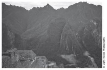
8.9B The photograph shows mountains in the Andes range in South America. Which statement describes the geologic process that is most likely responsible for the formation of these mountains?
45
They are along transform plate boundary in which plates are currently moving side by side causing earthquakes and faults.
They are along transform plate boundary that is no longer active, so erosion is creating deep valleys.
They are along a plate boundary in which plates diverged in the distant past allowing new rock to build up.
They are along a plate boundary in which plates are currently converging, causing uplift and steep slopes.
Q 2/10
Score 0
8.9B A mid-ocean ridge is located at the boundary of two tectonic plates. Which diagram correctly models the relative plate motion on each side of a mid-ocean ridge?
45
10 questions
Q.
8.9B The photograph shows mountains in the Andes range in South America. Which statement describes the geologic process that is most likely responsible for the formation of these mountains?
1
45 sec
8.9.B: Earth and Space
Q.
8.9B A mid-ocean ridge is located at the boundary of two tectonic plates. Which diagram correctly models the relative plate motion on each side of a mid-ocean ridge?
2
45 sec
8.9.B: Earth and Space
Q.
8.9B The map shows some of Earth’s plate boundaries.
Based on the map, volcanic activity would most likely be found at -
3
45 sec
8.9.B: Earth and Space
Q.
(8.9B) The map below shows the locations of four active volcanoes in the Caribbean Sea. What do these volcanoes indicate about plate tectonics in the region?
4
45 sec
8.9.B: Earth and Space
Q.
(8.9C) This topographic map represents the elevation of an area 100 years ago. At that time the highest point had an elevation of 214 m. The highest point has since eroded a total of 7 m.
5
45 sec
8.9.C: Earth and Space
Q.
(8.9C) This satellite photograph shows an area in Alaska after a fire occured.
Which statement best describes the most likely effect the fire had on the river in the 12 months after it occured?
6
45 sec
8.9.C: Earth and Space
Q.
(7.8C) Water flowing over soil composed of sand and gravel will most likely -
7
45 sec
Q.
The topographic map shows the location of a park ranger at Point X when a message is received that an injured hiker needs help at Point Z. Which of these is closest to the difference in elevation between locations of the ranger and the injured hiker?
8
45 sec
8.9.C: Earth and Space
Q.
(8.9C) Palo Duro Canyon in Texas Panhandle formed over a period of about one million years. This satellite image shows a portion of the canyon.
Which process most likely played the greatest part in the formation of the canyon?
9
45 sec
8.9.C: Earth and Space
Q.
(7.8C) A house has a well that pumps groundwater into the house so the homeowners can use it for drinking and other purposes. Which sentence below best explains how the septic tank and leach field prevent contamination of the groundwater?