Loading...

Grade XII - Geography.
Quiz by Grefita Serrao
Tag the questions with any skills you have. Your dashboard will track each student's mastery of each skill.
Study the outline map of India given below and choose the correct answer from the given options.
What is the angular value of the Standard Meridian of India marked L?

82° 30´ E
68° 7´ E
37° 6´ E
23° 30 N
The mountain range marked M is:
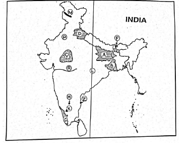
Ladakh Range
Pir Panjal Range
Karakoram Range
Nilgiri Hills
Study the outline map of India given below and choose the correct answer from the given options.
What is the angular value of the Standard Meridian of India marked L?

The mountain range marked M is:

The peak marked X is:

The plateau marked Y is bordered by the Aravali Range in the west and Vindhya Range in the south. This plateau is called:

The lake marked Z is:

The mountain pass marked F, that connects India with China is:

The west flowing river marked R which flows through a rift valley is:

The atmospheric pressure developed over the region marked P during the summer season is:

According to the Census (2011), which among the following states has recorded the highest density of population?

The city marked H is

Which of the following neighbouring countries share the longest boundary with India?
The Chaj Doab lies between the rivers:
The convectional storm occurring in the West Bengal and Assam region during the hot weather season is locally called:
__________________________________ is growing trees in the fields in place of food and agricultural crops for direct profit.
The land area of Australia is _________________ lakh sq km.
The highest mountain peak of Himalayas in India is ______________________ .
The __________________ river is also called Vridha Ganga.
The main cause of floods in Assam is ________________.
__________________ is a pass which is in the northern part of Western Ghats.
The State in India with the lowest density of population is:
Which period of Population growth in India is induced by high fertility?
The decade, 1991-2001 is known as the “Literacy Decade” because:
The chief cause of “Brain Drain” in India is:
The State in India which achieved Negative growth rate as per census 2011 is:
The city which displays features of a Conurbation is:
A metropolis has a minimum population of ___________.
A Marginal worker is one who is gainfully employed for ____________ months.
When suburbs grow along major roads, ________ settlements develop.
When population increases between two points of time, it is called____________ growth.
According to the census of 2011, the state of __________ has the highest density of population.
Which two methods are a solution to the problem of small and fragmented farm holdings?
What is the percentage of Net Sown Area and Net Forest area of India in present times?
Why is it essential to have knowledge of land use?
Name two modern methods of Irrigation.
What are the drawbacks of the traditional methods of irrigation?
The development that meets the needs of the present without compromising the ability of future generations is known as _________________________.
The distribution of groundwater in India is very uneven due to the ___________ and ______________.
Water is an important input for successful ________________.
Well irrigation is not possible in areas of ____________ groundwater.
The inundation canals are not popular as they are __________.