Obtain, evaluate, and communicate information to show how Earth’s surface is formed.
Track each student's skills and progress in your Mastery dashboards
Give this quiz to my class
Q 1/9
Score 0
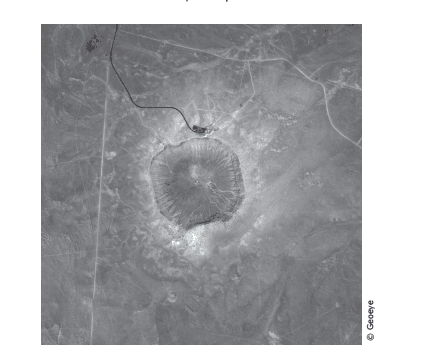
The satellite photograph below shows a large meteorite crater that is 1200 m in diameter and 170 m deep. This crater is located in a flat, arid part of northeastern Arizona. How will this crater most likely change over time?
60
It will rise up like a volcanic crater.
It will get deeper as it fills with water
It will widen as it fills with lava.
It will become less deep as the rim erodes.
Q 2/9
Score 0
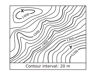
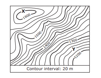
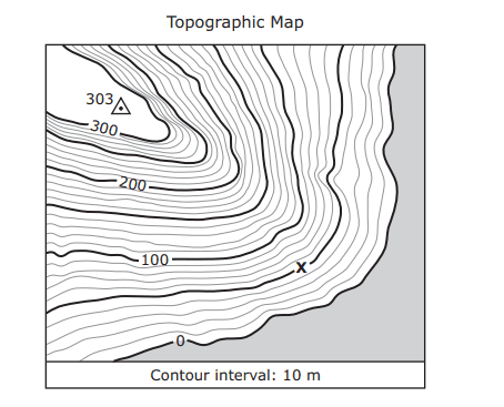
A section of a topographic map is shown below. What is the difference in elevation in meters between Point X and Point Y on the map? Be sure to use the correct place value.
60
Users enter free text
9 questions
Q.
The satellite photograph below shows a large meteorite crater that is 1200 m in diameter and 170 m deep. This crater is located in a flat, arid part of northeastern Arizona. How will this crater most likely change over time?
1
60 sec
S6E5
Q.
A section of a topographic map is shown below. What is the difference in elevation in meters between Point X and Point Y on the map? Be sure to use the correct place value.
2
60 sec
S6E5
Q.
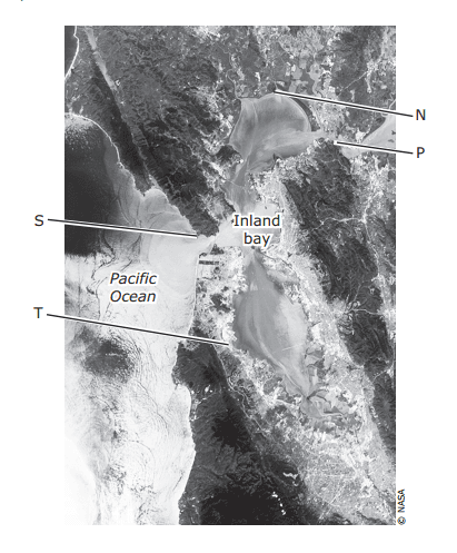
The satellite photo below shows San Francisco, California, which has many miles of coastline and an inland bay. Which area of the coastline has most likely experienced the greatest effect of erosion from waves over hundreds of years?
3
60 sec
S6E5
Q.
A student stands at the point marked X on the topographic map below. What height in meters must the student climb in order to reach the top of the hill? Be sure to use the correct place value.
4
60 sec
S6E5
Q.
The satellite image below shows a portion of the Namib Desert in Africa. This is an ancient, sandy desert with dunes that can be up to 305 m tall. The Namib Desert extends inland from the Atlantic Ocean between 80 km and 200 km and receives only 5 mm to 76 mm of rain each year. A satellite picture of this same area taken weeks before shows that the shape and location of some sand dunes have changed. Which of these most likely caused the changes in the dunes?
5
60 sec
S6E5
Q.
The satellite image below shows a ship channel between South Padre Island and Boca Chica beach in South Texas. Sand is sometimes removed from the ship channel through a process called dredging to make it easier for ships to travel through. Recently sand from the bottom of the channel was moved to area beaches. Without this transfer of sand, what would most likely occur in this area in the future?
6
60 sec
S6E5
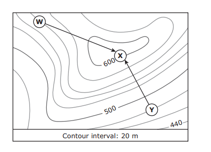
Q.
The points labeled W and Y on the topographic map below show the campsites of two families. Each family hiked to the elevation on the map marked X. The arrows show the paths taken by both families. What was the change in elevation, to the nearest ten meters, for the family that took the steepest path to Point X? Be sure to use the correct place value.
7
60 sec
S6E5
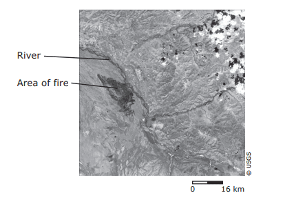
Q.
This satellite photograph shows an area in Alaska after a fire occurred. Which statement best describes the most likely effect the fire had on the river in the 12 months after it occurred?
8
60 sec
S6E5
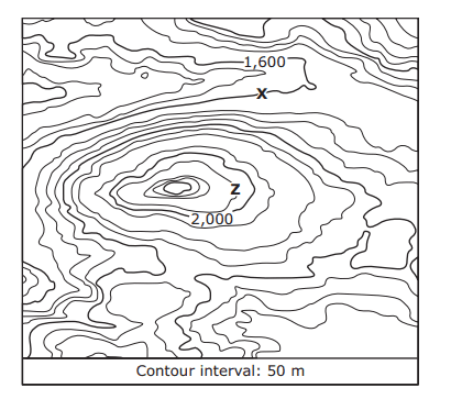
Q.
The topographic map shows the location of a park ranger at Point X when a message is received that an injured hiker needs help at Point Z. Which of these is closest to the difference in elevation between the locations of the ranger and the injured hiker?