Loading...

NY Released Regents Exam - Earth Science (Aug 2023)
Quiz by NYSED Earth Science
Track each student's skills and progress in your Mastery dashboards
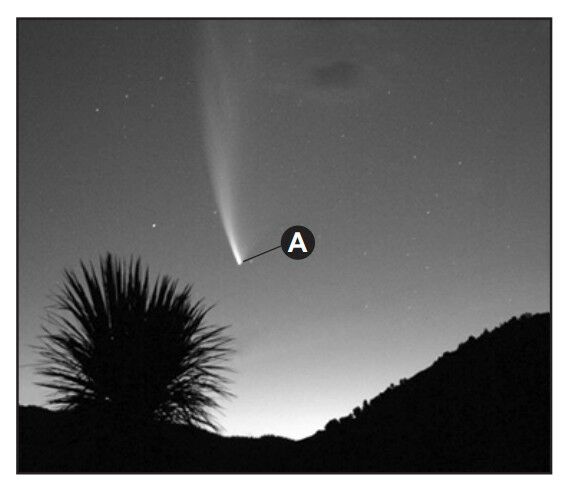
The photograph below shows an object, labeled A, that was observed in the night sky for several weeks.
What is the celestial object labeled A?
a comet
a galaxy
an asteroid
a meteor
Which two factors caused Earth and the other planets to become layered during the formation of our solar system?
The photograph below shows an object, labeled A, that was observed in the night sky for several weeks.
What is the celestial object labeled A?

The latitudes of the Tropic of Cancer and the Tropic of Capricorn are determined by Earth’s
The Coriolis effect can best be used to explain the
What is Earth’s approximate rate of revolution?
At a location in the Northern Hemisphere, a camera was placed outside at night with the lens pointing at a group of stars. The shutter was left open for a few hours, resulting in the image of star trails shown below.
The star at the center of the image did not leave a trail because the star is

Which table best lists the differences between a terrestrial planet and a Jovian planet in our solar system?
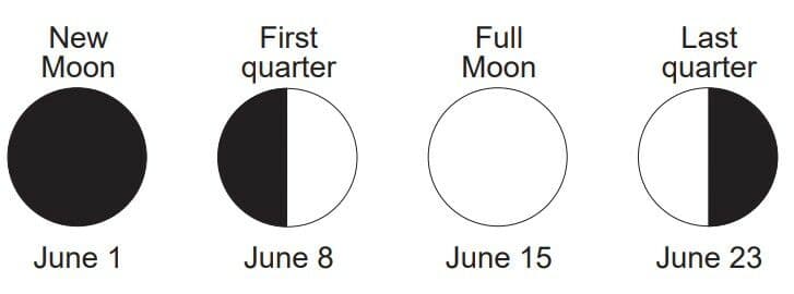
The names and appearances of four Moon phases viewed by an observer in New York State in June are shown below.
Which diagram best represents the Moon’s appearance on June 3?
Which graph most accurately represents the approximate percentage of Earth’s surface covered by the hydrosphere?
Which diagram shows the correct position of Polaris in the night sky as seen by an observer at Watertown, NY?
Which process transports groundwater upward through the soil to the surface, where it quickly evaporates during a dry season?
The diagram below represents four cylinders of particles, labeled 1 through 4. Cylinders 1 through 3 each contain equal volumes of round particles of uniform size. Cylinder 4 contains round mixed-size particles. Sizes of particles are indicated for each cylinder.
Which cylinder contains the particles with the lowest porosity?

Which factor is responsible for the circulation of convection currents occurring in the hydrosphere, troposphere, and mantle?
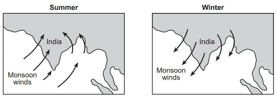
The arrows on the two maps below show how the monsoon winds blow over India during the summer and winter seasons.
Compared to the amount of rainfall that India receives during the summer monsoon season, the amount of rainfall that India receives during the winter monsoon season is
The map shows the location of the polar front jet stream during winter. This winter weather pattern brings extremely cold air from the far north into the United States.
Which map shows the type of air mass and the direction of polar front jet stream flow associated with this winter weather pattern?

The map shows the location of the polar front jet stream during winter. This winter weather pattern brings extremely cold air from the far north into the United States.
In which atmospheric temperature zone is the polar front jet stream located?

Which diagram correctly matches the weather front symbol with its atmospheric cross section?
If the Tug Hill Plateau region of New York State is experiencing lake-effect snow, winds are most likely blowing in which direction?
Compared to the summer and winter temperatures at low elevations, higher elevations at the same latitude have
During which geologic period did humans first appear on Earth?
The graph below shows the radioactive decay of potassium-40.
Approximately what percentage of potassium-40 remains in the 1.0 billion-year-old bedrock of the Hudson Highlands landscape region of New York State?

The surface bedrock at Old Forge, New York, is mostly
Which agent of erosion produced many of the large parallel grooves and scratches seen in surface bedrock across New York State?
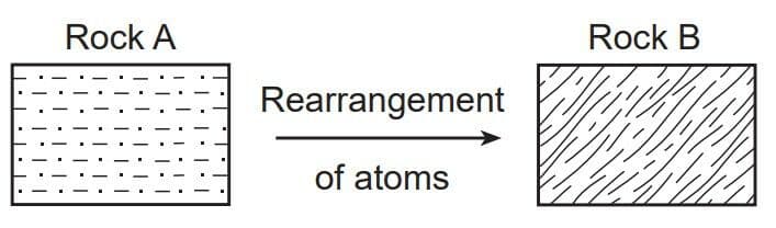
The diagram below represents rock A changing into rock B.
Which process causes rock A to change into rock B?
Which mineral is usually present in pegmatite, phyllite, and siltstone?
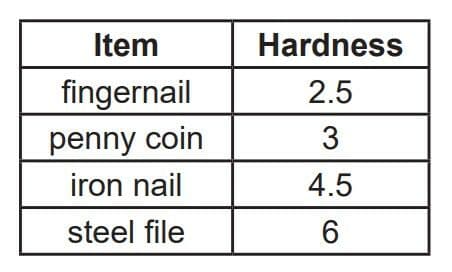
The table below shows the hardness of some common items.
Which mineral could be scratched by an iron nail, but not by a penny coin?
Which graph shows the general relationship between an increase in urbanization in an area and the average annual air temperature for that area?
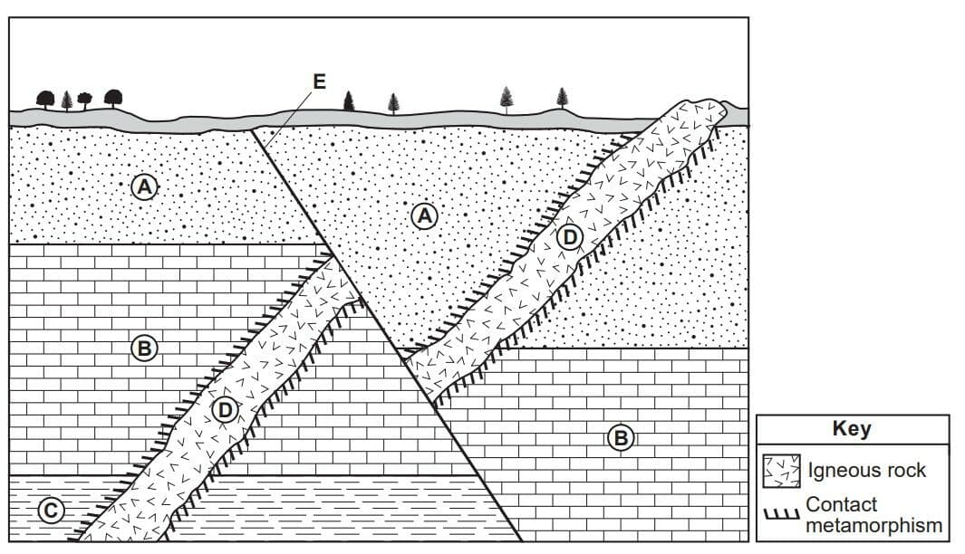
The cross section below represents sedimentary rock layers A, B, and C. An igneous intrusion is labeled D. Line E represents a fault. Overturning has not occurred.
Which events occurred after the formation of rock layer A?
The diagram below represents magnetic patterns of normal and reversed polarity of ocean crust on the west side of a mid-ocean ridge. Letters A, B, C, D, and E represent locations on the seafloor on the east side of the mid-ocean ridge.
Which two locations on the east side of the mid-ocean ridge represent areas of reversed magnetic polarity?

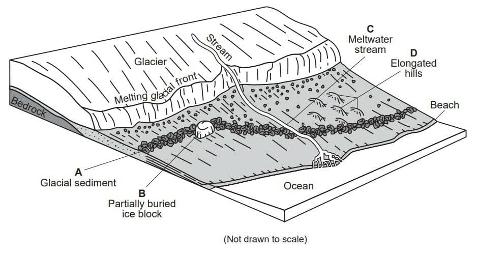
Letters A through D on the block diagram below represent four features resulting from glaciers.
Which feature will later form a kettle lake?
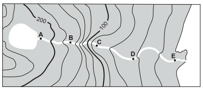
The topographic map below shows the path of a river. Points A through E are locations in the river.
Between which two points is the river flowing the fastest?
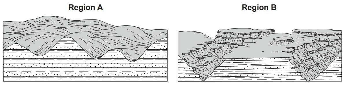
The diagrams below represent landscapes in regions A and B.
Which chart best summarizes the landscape type and climate of regions A and B?
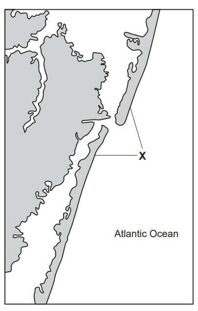
The map below shows a coastal landscape feature, labeled X, that resulted from wave action and offshore currents parallel to the coastline.
Which landscape feature is represented by X?
Hurricane Sandy
Hurricane Sandy was one of the most severe hurricanes to affect the northeastern United States in many years. On October 29, 2012, this storm made landfall in New Jersey. It produced a 14-foot storm surge, which is a rise in the level of ocean water along a coast caused by strong winds and low air pressure. The Moon also enhanced the effects of this storm surge, since the Moon was in full phase at the time Hurricane Sandy made landfall. During a full Moon, above-normal high tides occur on Earth.
What was the surface wind circulation pattern around the center of Hurricane Sandy?
Hurricane Sandy
Hurricane Sandy was one of the most severe hurricanes to affect the northeastern United States in many years. On October 29, 2012, this storm made landfall in New Jersey. It produced a 14-foot storm surge, which is a rise in the level of ocean water along a coast caused by strong winds and low air pressure. The Moon also enhanced the effects of this storm surge, since the Moon was in full phase at the time Hurricane Sandy made landfall. During a full Moon, above-normal high tides occur on Earth.
Which air temperature and moisture characteristics are associated with the source region over which Hurricane Sandy formed?
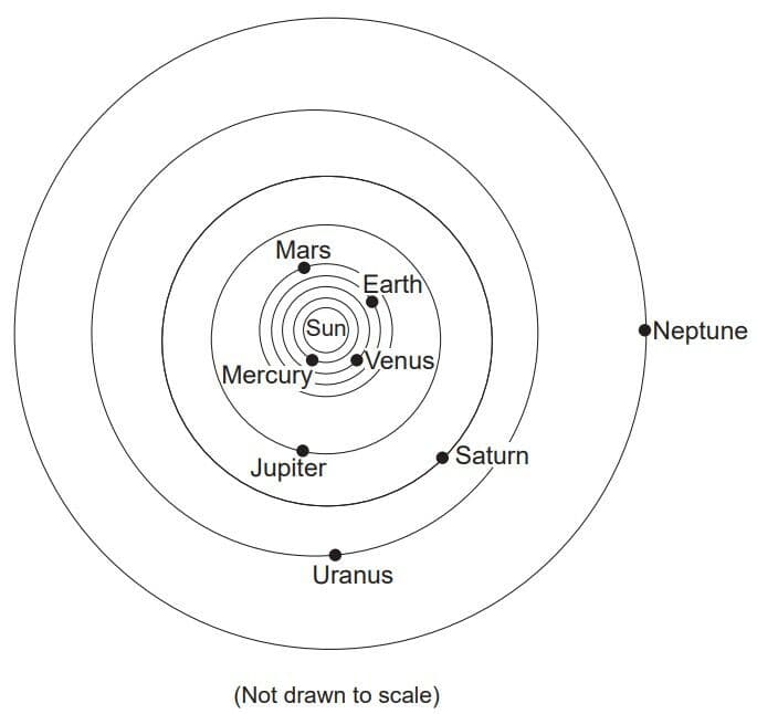
The diagram represents a model of a portion of our solar system.
In our solar system, the orbits of the planets are best described as

The diagram represents a model of a portion of our solar system.
Which planet takes approximately twice as long as Earth to complete one revolution around the Sun?
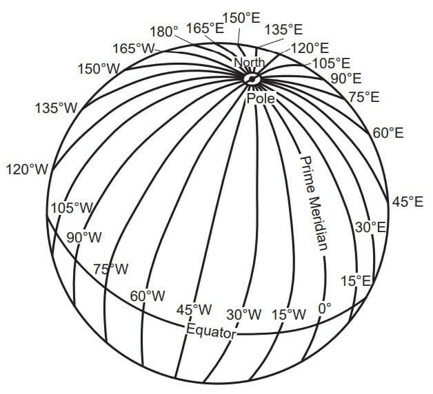
The diagram of Earth shows the longitude lines that are used to determine time zones.
Which longitude line passes through New York State?

Letters A through E represent rock units. Letter F represents a geologic feature. Some layers contain index fossils.
Which geologic principle could be used to support the inference that rock layers A through D experienced crustal movement?

Letters A through E represent rock units. Letter F represents a geologic feature. Some layers contain index fossils.
During the Ordovician Period when layer C was forming, most of the United States was inferred to be located
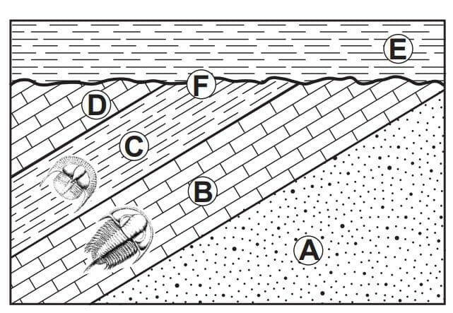
Letters A through E represent rock units. Letter F represents a geologic feature. Some layers contain index fossils.
The geologic feature represented by letter F is most likely a

Letters A through E represent rock units. Letter F represents a geologic feature. Some layers contain index fossils.
Carbon-14 was not used to date the trilobite fossils represented in the cross section because these trilobites

The diagram represents the water cycle. Letters A through F represent water cycle processes. The water table has been labeled.
Which water cycle process releases 2260 joules of heat energy per gram of water?
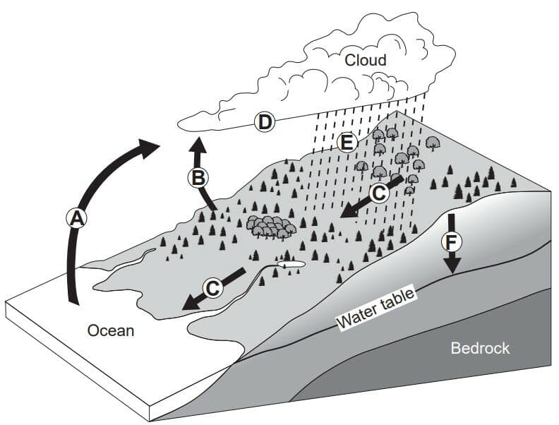
The diagram represents the water cycle. Letters A through F represent water cycle processes. The water table has been labeled.
Which diagram would most likely represent the height of the water table if processes E and F increased?

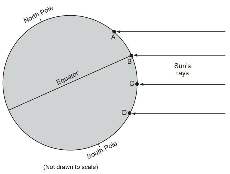
The diagram represents insolation received on four Earth land surfaces at locations A, B, C, and D.
Which location is receiving direct rays from the Sun?

The diagram represents insolation received on four Earth land surfaces at locations A, B, C, and D.
Equal areas of which type of land surface usually absorb the most insolation and reflect the least insolation?

The diagram represents insolation received on four Earth land surfaces at locations A, B, C, and D.
Most of the energy radiated by these land surfaces into space is in the form of