Loading...
NY Released Regents Exam - Earth Science (Aug 2024)
Quiz by NYSED Earth Science
Track each student's skills and progress in your Mastery dashboards
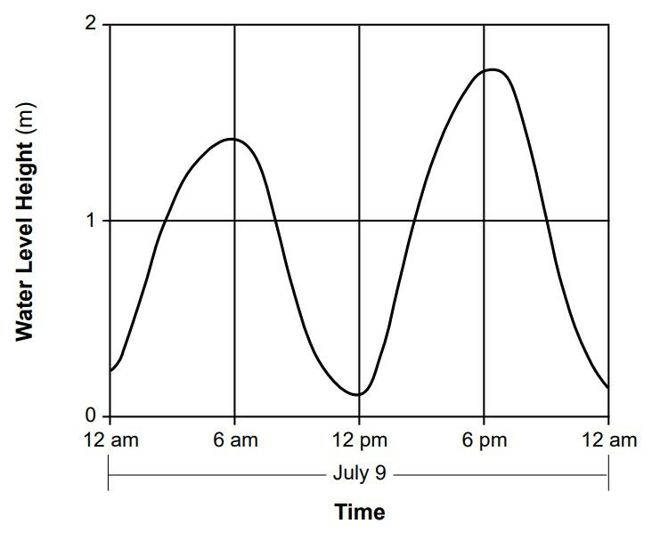
The graph below shows the change in water level height measured in meters (m) at the Brooklyn Bridge in New York City on July 9, 2018.
According to the pattern shown on the graph, the next high tide will occur on July 10 at approximately
6:53 p.m.
6:53 a.m.
5:24 a.m.
5:24 p.m.
The graph below shows the change in water level height measured in meters (m) at the Brooklyn Bridge in New York City on July 9, 2018.
According to the pattern shown on the graph, the next high tide will occur on July 10 at approximately

Which event is correlated with an asteroid impact on Earth that occurred approximately 65 million years ago?
Light observed from most galaxies in our universe shows a shift toward the
The Milky Way is classified as a
What is the approximate altitude of Polaris at Riverhead, New York?
Which instrument provides direct evidence of Earth’s rotation?
Rural areas on Long Island, New York, receive approximately the same amount of yearly precipitation as the urban areas of New York City. Compared to rural areas on Long Island, the urban areas of New York City most likely have
Which diagram best represents the positions of the equator, Earth’s axis with the North Pole labeled (N), and Polaris (*) relative to each other?
Earth’s early atmosphere is inferred to have been formed during the Early Archean Era primarily by
In the water cycle, it can be inferred that precipitation has occurred if
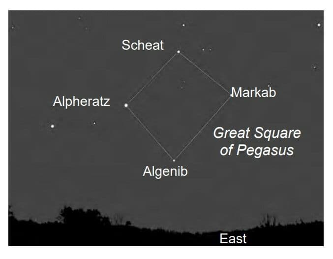
The photograph below shows the Great Square of Pegasus, consisting of a pattern of four stars, as viewed from New York State during the fall season.
Which motion causes this square pattern of stars to be visible in the nighttime sky from New York State in the fall, but not in the spring?
The arrow on which map shows the most likely path of a hurricane in the Atlantic Ocean?
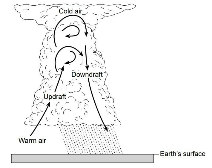
The diagram below represents a thunderstorm cloud. Arrows represent air motion within the cloud.
This air motion is caused by
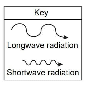
Which diagram best represents the wavelength of incoming solar radiation received on Earth and the wavelength of outgoing radiation?
Which statement best explains why most of the surface of Lake Erie usually remains as liquid water in late autumn, even though surrounding land surfaces and air temperatures may be below freezing?
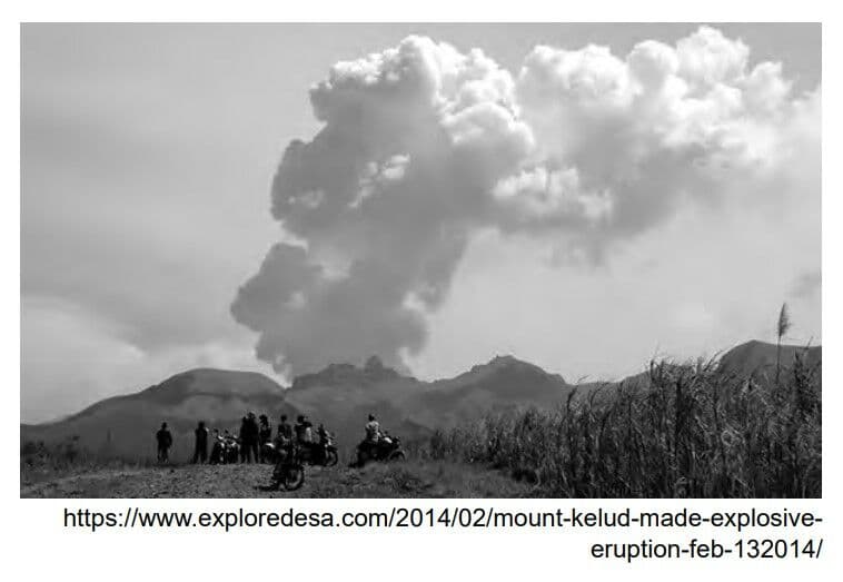
The photograph below shows the large-scale eruption of volcanic ash from Mount Kelud in Indonesia in 2014.
This volcanic ash in the atmosphere causes
Ireland and England, islands along the northwest coast of Europe, have climates that are warmer than the climate of New York State, even though these islands are located farther north. This increased average temperature is mostly due to heat supplied by the prevailing winds and the
The diagram below shows the front fin bones of a Devonian fish and the front leg bones of a present-day amphibian.
Similarities in bone structure and arrangement between these two animals support the inference that these animals

Surface bedrock found in the St. Lawrence Lowlands region of New York State was formed during which periods of geologic time?
Volcanic ash is most useful for determining the relative age of rock layers because the ash is deposited during a
Sediments that form a sedimentary rock usually are deposited in a layer that is parallel to Earth’s surface. This statement best describes the
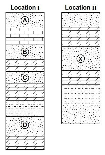
The diagram below represents rock columns I and II, found at two different locations. Different rock layers are labeled. The rock layers have not been overturned.
Which labeled rock layer at location I would most likely have the same relative age as rock layer X at location II?
Which evidence supports the inference that South America and Africa were once joined together as part of the supercontinent Pangaea?
The Tonga Trench is located at which type of plate boundary?
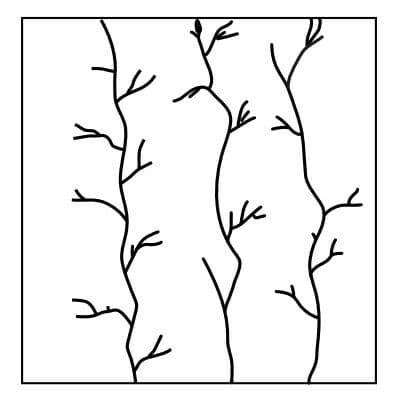
The map below shows a stream drainage pattern.
This drainage pattern most likely formed on the surface bedrock of which block diagram?
The Hudson River begins its flow at Lake Tear of the Clouds, near Mt. Marcy, New York, where it has a surface elevation of 4293 feet. It travels 162 miles to Troy, New York, where the river’s surface elevation is two feet. The gradient of the Hudson River between Lake Tear of the Clouds and Troy is approximately
The mountain landscape at Old Forge, New York, and the plateau landscape at Slide Mt., New York, are classified based on the differences in
The diagram below represents a landscape region located in the southwestern United States. The steep slopes and sharp angular features of this region indicate that, compared to New York State, the climate where this landscape is developing most likely has

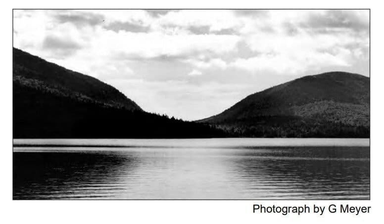
The photograph below shows a valley between two mountains in Acadia National Park in the state of Maine.
The shape of this valley is best described as
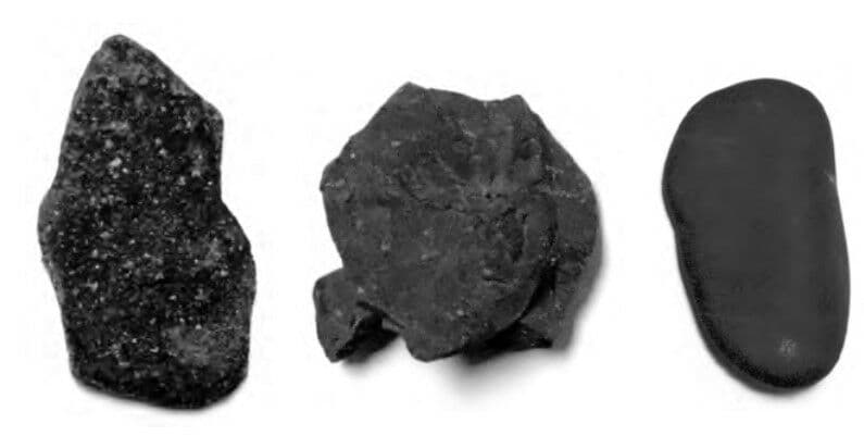
The photograph below shows three different pebbles that have been transported for different amounts of time in a stream.
The erosional process that has shaped these pebbles over time is
Which satellite photograph below best shows the result of the deposition of river sediments into a large body of water?
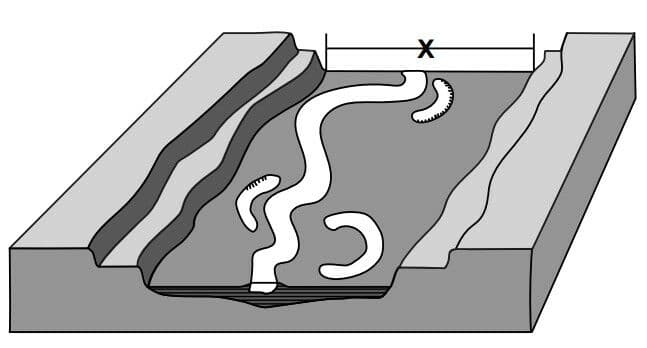
The diagram below represents a stream in a valley. Letter X represents a surface feature associated with the stream.
Which surface feature is represented by letter X?
The famous green-sand beach on the Big Island of Hawaii gets its color from green colored grains of which mineral?
Which metamorphic rock forms only by contact metamorphism?
The cross section below shows the bedrock structure beneath a portion of the Hudson Highlands and Newark Lowlands landscape regions along the border between New York State and northern New Jersey. Letters X and Y identify bedrock units shown in the cross section. The Palisades Sill igneous intrusion is identified.
Fossil evidence of which animal is most likely preserved in bedrock unit X?

Compared to the other bedrock units, the relative age of the Palisades Sill intrusion is
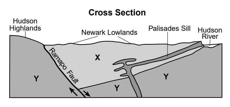
Approximately how many million years ago (mya) did the intrusion of the Palisades Sill occur?

The map represents an imaginary continent on a planet that has climate conditions similar to Earth. Points A through G represent locations on the continent. The arrows represent the general direction of the prevailing winds.
Which climate factor causes location B to have a warmer climate than location E?

At which location does high elevation cause temperatures to remain low all year with frequent snow events?

The diagrams represent the apparent paths and solar noon positions of the Sun on specific dates at four different Earth locations, labeled A, B, C, and D.
At which location and on which date would the observer not experience sunrise or sunset?
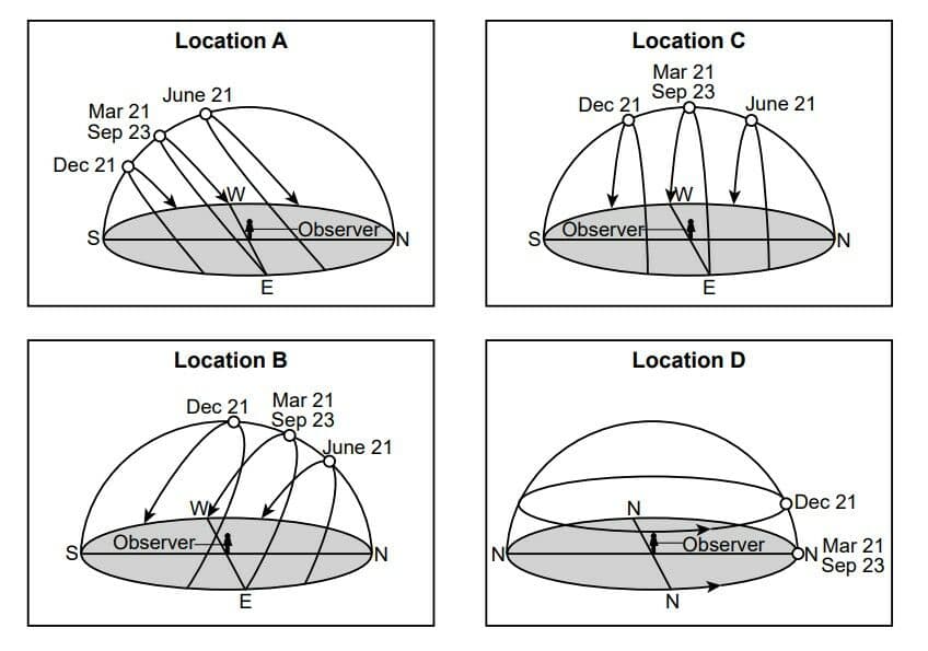
For the observer at location B, the Sun appears to move across the sky on June 21 at the rate of

Which phrase most accurately describes the length and direction of the observer’s noontime shadow at location C on December 21 and June 21?

Which statement best explains why the solar noon position of the Sun changes throughout the year at each of these locations?

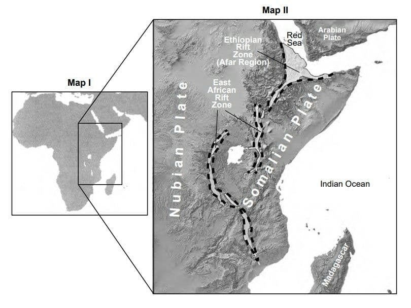
Map I shows a boxed area in Africa that includes the East African Rift System. Map II shows details of the boxed area including rifts and developing plates. The dashed lines represent the borders of the rift zone.
The East African Rift System
The entire East African Rift System, which includes both the Ethiopian Rift and East African Rift, is located along the edges of three tectonic plates. The rifts that are the oldest and widest are in the Afar region to the north. The entire system extends southward, covering thousands of kilometers in Africa. In April 2018, a large crack, extending and stretching several kilometers, formed in the eastern branch of the East African Rift. Tectonic activity such as this causes larger plates to break up into smaller plates.
What event is associated with the formation of the large crack in the eastern branch of the East African Rift in April 2018?
The East African Rift System
The entire East African Rift System, which includes both the Ethiopian Rift and East African Rift, is located along the edges of three tectonic plates. The rifts that are the oldest and widest are in the Afar region to the north. The entire system extends southward, covering thousands of kilometers in Africa. In April 2018, a large crack, extending and stretching several kilometers, formed in the eastern branch of the East African Rift. Tectonic activity such as this causes larger plates to break up into smaller plates.
Which characteristic best describes the rock that forms at Earth’s surface where these active rifts occur?

The East African Rift System
The entire East African Rift System, which includes both the Ethiopian Rift and East African Rift, is located along the edges of three tectonic plates. The rifts that are the oldest and widest are in the Afar region to the north. The entire system extends southward, covering thousands of kilometers in Africa. In April 2018, a large crack, extending and stretching several kilometers, formed in the eastern branch of the East African Rift. Tectonic activity such as this causes larger plates to break up into smaller plates.
On which major tectonic plate is the Afar Region located?

The diagram represents our solar system planets in order of distance from the Sun. In which set of planets is the orbital period of revolution of the first planet listed approximately one-half the orbital period of revolution of the second planet listed?

Compared to the planets closer to the Sun, the planets beyond Mars have

The solar system formed from