Loading...

NY Released Regents Exam - Earth Science Jun 2021(v202)
Quiz by NYSED Earth Science
Track each student's skills and progress in your Mastery dashboards
The graph below shows changing ocean tide heights in feet (ft) on April 7 for a coastal location.
The next high tide will occur on April 8 at approximately
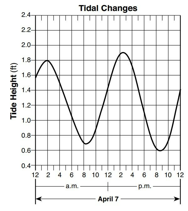
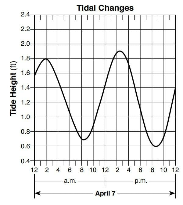
3 a.m.
10 p.m.
10 a.m.
3 p.m.
The graph below shows changing ocean tide heights in feet (ft) on April 7 for a coastal location.
The next high tide will occur on April 8 at approximately
Scientists who proposed the Big Bang Theory were attempting to explain
Which star type has a surface temperature of 4000 K and a luminosity 1000 times greater than the Sun?
The red shift in light from stars located in very distant galaxies suggests that these stars are
A Foucault pendulum provides evidence that Earth
How many days during one year is the Sun directly overhead at noon in New York City?
Approximately which percentage of Earth’s surface is exposed above water?
On June 21, an observer in New York State will see the Sun set
Compared to a well-sorted sample of larger-sized particles, a well-sorted sample of smaller-sized particles has greater
The photographs below show two celestial objects just before, during, and just after a total solar eclipse as viewed by an observer located in Kingston, Tennessee, on August 21, 2017.
Which diagram represents the location of the Moon in its orbit at the time that each of these three photographs (1, 2, and 3) were taken? (Diagrams are not drawn to scale.)

The diagram below represents Earth in four positions, labeled A, B, C, and D, in its orbit around the Sun on the first day of each season.
Between which two consecutive positions is the summer season occurring in the Northern Hemisphere?

Which atmospheric conditions occur when the dry-bulb temperature is 30°C and the difference between the dry-bulb temperature and wet-bulb temperature is 1°C?
Which precaution is most appropriate during a blizzard?
The graph below shows the relationship between the distance that wind blows over a body of water and the height of the waves that are generated.
A west wind blowing with the same velocity would generate the highest waves along the shoreline at

The weather map below shows a storm centered north of Iceland. Points A, B, C, and D indicate locations on Earth’s surface. Isobars are labeled in millibars.
Which location was probably experiencing the highest wind speed?

The map below shows a cold, arctic air mass that moved southeast from Canada to cover most of the eastern half of the United States during January 2010.
Which shift caused this flow of cold air out of Canada?

Which surface ocean current cools the climate of the western coastline of South America?
When equal masses of ice and liquid water receive the same amount of energy, without a change in state, the ice changes temperature faster than the liquid water does because the
El Niño is a condition associated with a buildup of unusually warm water along the western coast of South America. Which changes in air temperature and precipitation usually occur in that region during El Niño?
Which conclusion can be drawn from the pattern of fossils found in Earth’s rock record?
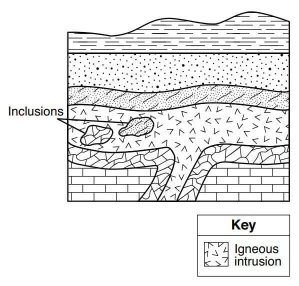
The geologic cross section below represents a portion of Earth’s crust. The rock layers have not been overturned.
The inclusions were most likely broken off from their original rock layers
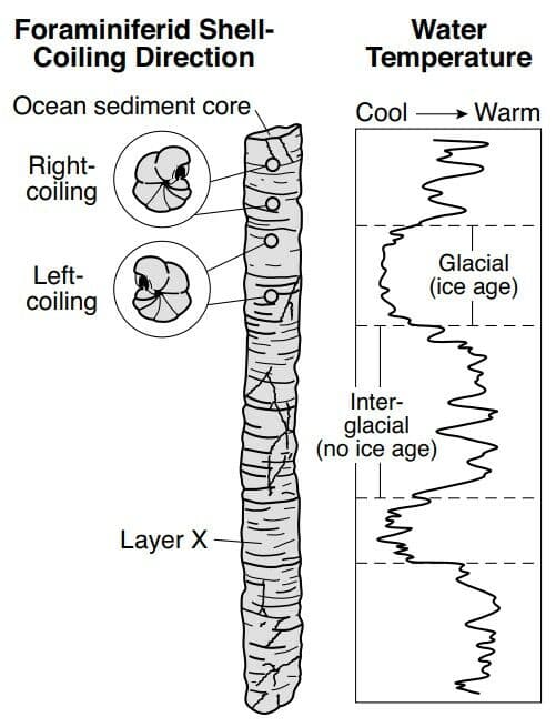
While studying sediments deposited during and after the last ice age, scientists discovered that foraminiferid shells coil in different directions when they grow under different temperature conditions, as shown in the diagram below.
Foraminiferid shells found in layer X most likely coiled to the
Approximately how many million years ago (mya) was the amount of Earth’s total landmass located south of the equator the greatest
Which layer of Earth’s interior is inferred to be composed of solid iron and nickel?
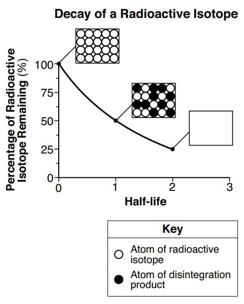
The graph below shows the rate of decay of a radioactive isotope through two half-lives. Each box shows the ratio of atoms of the radioactive isotope to atoms of the disintegration product. The box at two half-lives has been left blank.
Which box best represents the ratio of these atoms at two half-lives?
The first S-wave reaches a seismic station 22 minutes after an earthquake occurred. How long did it take the first P-wave to reach the same seismic station?
The block diagram below represents the formation of an island arc near a plate boundary.
An island arc is located near the boundary between which two tectonic plates?

Which table correctly matches the average density and composition of continental and oceanic crusts?
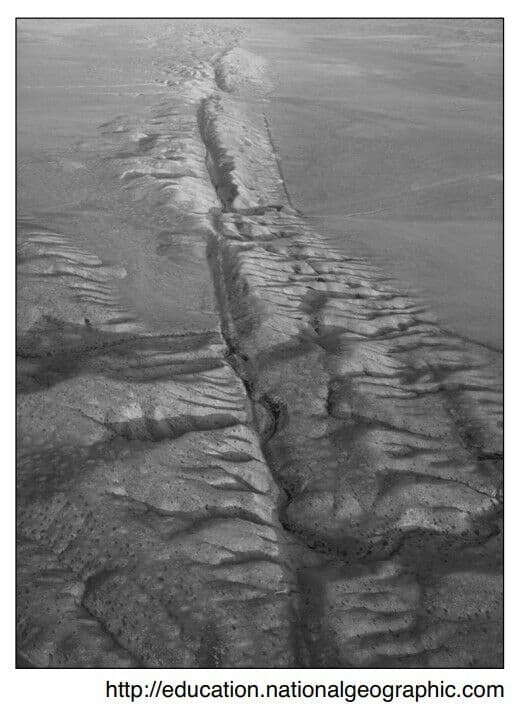
The photograph below shows a portion of the San Andreas Fault in the western United States.
The San Andreas Fault is an example of a
What is the minimum stream velocity necessary to transport a quartz particle that is 0.1 centimeter in diameter in a stream?
Scoria is a type of rock that forms most directly from the process of
The element silicon (Si) is used in the production of cell phones. Which mineral could be a possible source of this silicon?
The block diagram below shows a portion of a deeply eroded dome landscape.
Which map shows the stream pattern that probably formed on the surface of this landscape?

Which two New York State locations have surface bedrock of similar ages?
The aerial photograph below shows small, circular bodies of water surrounded by sediment in an area that was once covered by glaciers.
These bodies of water are known as

The diagram represents a simplified model of the incoming (solar) and outgoing (terrestrial) electromagnetic radiation of Earth’s energy budget.
Which color and texture of Earth materials absorbs the greatest amount of short-wave radiation from the Sun?

The diagram represents a simplified model of the incoming (solar) and outgoing (terrestrial) electromagnetic radiation of Earth’s energy budget.
Two major greenhouse gases that absorb outgoing long-wave radiation within the atmosphere are
Southeast Asia Monsoons
The Southeast Asia monsoons are seasonal shifts in the direction of regional planetary winds. These shifts are related to the movement of air pressure belts as the Sun’s vertical ray changes latitude. In the late spring, winds begin to blow from the southwest, bringing moisture from the Gulf of Thailand across Southeast Asia. Rainfall reaches a peak in July and August. This moisture is partially blocked by the Annamite Mountains, located along the border between Vietnam and Laos. Therefore, the rainfall in central Vietnam is somewhat less during these months. In September, the winds reverse direction and begin to flow from the northeast across the Gulf of Tonkin and South China Sea. This wind shift begins the season of heavy rainfall in central Vietnam that continues for months.
Heavy rains occur in Cambodia and Thailand when the moist air brought by the monsoon
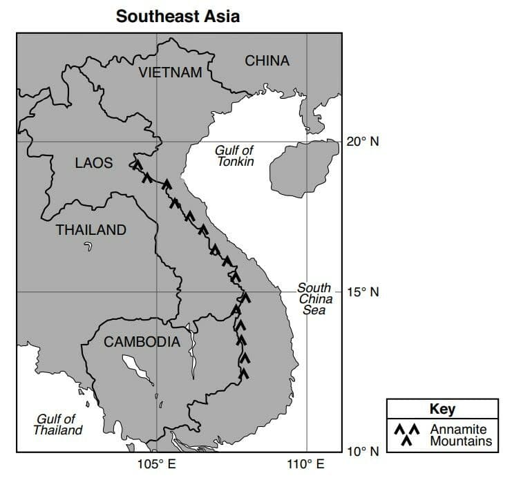
Southeast Asia Monsoons
The Southeast Asia monsoons are seasonal shifts in the direction of regional planetary winds. These shifts are related to the movement of air pressure belts as the Sun’s vertical ray changes latitude. In the late spring, winds begin to blow from the southwest, bringing moisture from the Gulf of Thailand across Southeast Asia. Rainfall reaches a peak in July and August. This moisture is partially blocked by the Annamite Mountains, located along the border between Vietnam and Laos. Therefore, the rainfall in central Vietnam is somewhat less during these months. In September, the winds reverse direction and begin to flow from the northeast across the Gulf of Tonkin and South China Sea. This wind shift begins the season of heavy rainfall in central Vietnam that continues for months.
Which map shows the most likely location and direction of the monsoon winds and regional atmospheric pressure occurring in Southeast Asia in July?
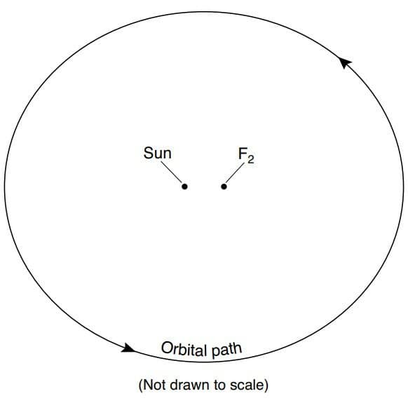
The diagram represents one position of Earth in its orbit around the Sun and 12 constellations that can be seen in the night sky by an observer in New York State at different times of the year. The approximate locations of the constellations in relation to Earth’s orbit are shown. Point A represents another position in Earth’s orbit.
When Earth is located in the orbital position shown on the diagram, which constellation is visible to an observer in New York State at midnight?

The diagram represents one position of Earth in its orbit around the Sun and 12 constellations that can be seen in the night sky by an observer in New York State at different times of the year. The approximate locations of the constellations in relation to Earth’s orbit are shown. Point A represents another position in Earth’s orbit.
Approximately how many days (d) does it take for Earth to orbit from its present position to point A?
The cross sections represent three widely spaced rock outcrops labeled A, B, and C. Line XY represents a fault. Overturning has not occurred.
What is the youngest sedimentary rock layer represented in these cross sections?

The cross sections represent three widely spaced rock outcrops labeled A, B, and C. Line XY represents a fault. Overturning has not occurred.
Which sequence shows the relative ages of the igneous intrusion, fault X–Y, unconformity, and red sandstone, from oldest to youngest, in outcrop C?
The cross sections represent three widely spaced rock outcrops labeled A, B, and C. Line XY represents a fault. Overturning has not occurred.
Which processes formed the unconformities shown in outcrops B and C?
The cross sections represent three widely spaced rock outcrops labeled A, B, and C. Line XY represents a fault. Overturning has not occurred.
Which characteristic of the volcanic ash layer is most useful for correlating rock layers in outcrops A, B, and C?
The diagram represents an erosional-depositional system in an arid environment, and indicates the processes occurring at various locations within the atmosphere and on the land surface. The box labeled X identifies one sand dune. Arrows represent the movement of particles.
Which agent of erosion moves the particles within this erosional-depositional system?

The diagram represents an erosional-depositional system in an arid environment, and indicates the processes occurring at various locations within the atmosphere and on the land surface. The box labeled X identifies one sand dune. Arrows represent the movement of particles.
The total range of particle sizes indicated in this system is
The diagram represents an erosional-depositional system in an arid environment, and indicates the processes occurring at various locations within the atmosphere and on the land surface. The box labeled X identifies one sand dune. Arrows represent the movement of particles.
Which diagram indicates both the direction of dune migration (movement) and the dominant process occurring on each slope of the dune in box X?