Loading...

NY Released Regents Exam - Earth Science (Jan 2023)
Quiz by NYSED Earth Science
Track each student's skills and progress in your Mastery dashboards
The apparent change in direction of swing of a Foucault pendulum, at one specific location, provides evidence that Earth
The presence of cosmic background radiation is evidence that helps support the
In New York State, the highest altitude of Polaris will be observed at
Earth’s rate of revolution is approximately
As water vapor changes phase from gas to liquid, each gram of water vapor
At the time of an equinox, the subtropical jet streams in Earth’s troposphere generally are located closest to
Which ocean current warms the climate along a continent’s east coast?
Which process transfers heat energy through molecular collisions?
Two major greenhouse gases that can be found in Earth’s atmosphere are
Which event causes a temporary slowing or reversal of the surface ocean currents in the equatorial region of the Pacific Ocean, which may disrupt normal weather patterns in North America?
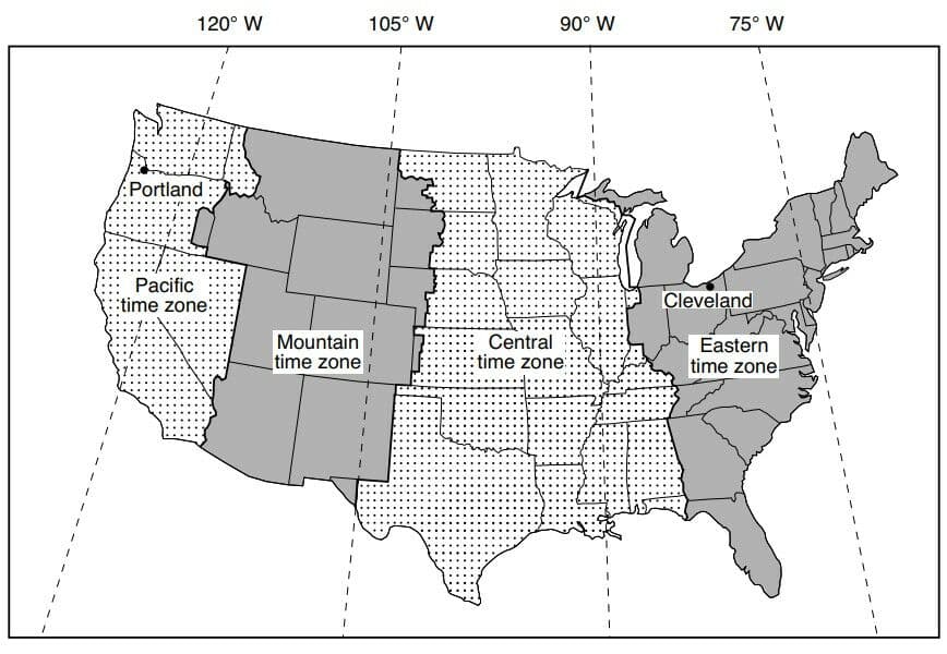
The map below shows the time zones of the continental United States. The dashed lines represent meridians of longitude. The locations of Cleveland, Ohio, and Portland, Oregon, are shown.
What time is it in Portland, Oregon, when it is 9 p.m. in Cleveland, Ohio?
The diagrams below represent the constellations that are visible above the southern horizon at midnight from the same New York State location on two different dates of the year.
Why are different constellations seen on these two dates at midnight?

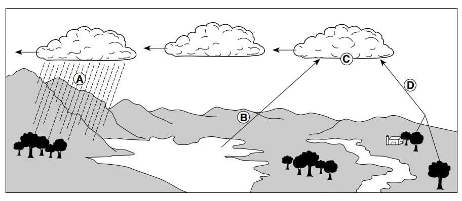
Letters A, B, C, and D in the diagram below represent processes in the water cycle.
Which letter represents the process of transpiration?
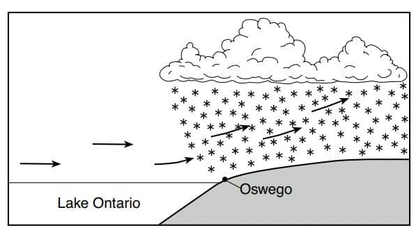
The cross section below represents a lake-effect snowstorm that resulted from air moving across Lake Ontario and over Oswego, New York.
These lake-effect snowstorms commonly occur in the region around Oswego during winter because Lake Ontario
Assuming that no overturning of rock layers has occurred, which geologic outcrop containing New York State index fossils represents the correct sequence of time within the same group of organisms?
Equal areas of which type of surface absorb the most insolation?
Which material requires the least amount of heat energy to raise its temperature one Celsius degree?
One characteristic of a good index fossil is that the organisms that produced these fossils
During which geologic epoch was nearly all of Earth’s landmass inferred to have been located in the Southern Hemisphere?
The Alleghenian orogeny occurred as a result of the
Which concept states that most sediments are deposited in layers that are fl at and parallel to Earth’s surface?
Which layer of Earth’s interior is inferred to be composed mostly of iron and nickel, and has an interior temperature that is greater than its melting point?
A seismic station that is 4000 kilometers from the epicenter of an earthquake records the arrival time of the first P-wave at 10:00:00 (hours: minutes: seconds). At what time did the first S-wave arrive at this station?
What is the approximate latitude and longitude of the Bouvet Hot Spot?
As the distance from the Mid-Atlantic Ridge increases, the age of the ocean floor surface bedrock
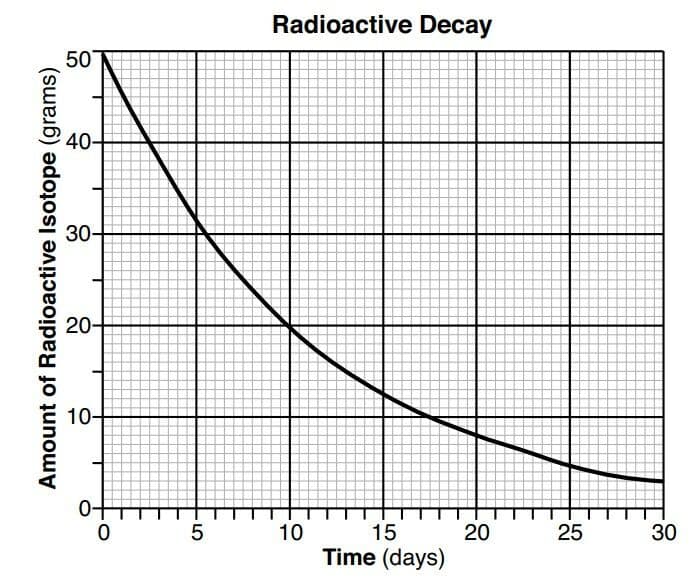
The graph below shows the decay of a 50-gram sample of a radioactive isotope over 30 days.
The half-life of this radioactive isotope is approximately
Based on fossil evidence, which pie graph best shows the percentage of time that humans have existed on Earth since the time of Earth’s origin?
The photograph below shows a cone-shaped volcano.
Which stream drainage pattern most likely will be found on this volcano?

The topographic map below shows the surface features of a coastal location. Line XY is a reference line on the map.
Which profi le best shows the landscape elevations along line XY?
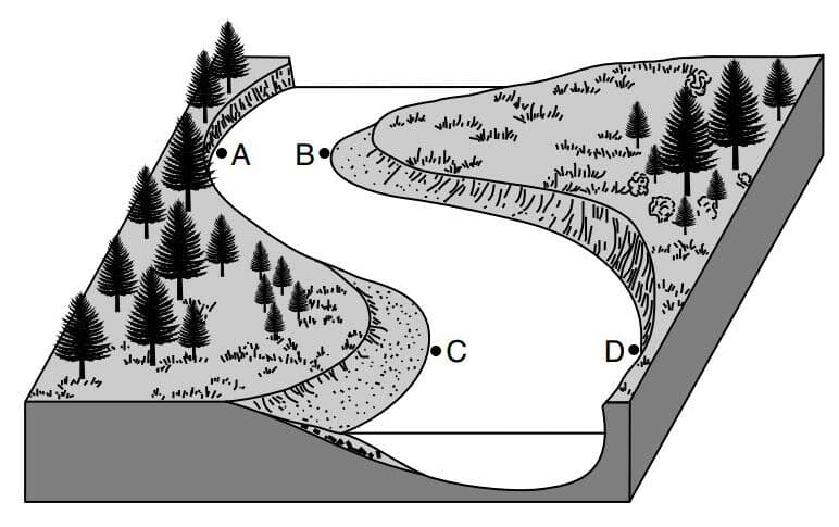
The block diagram below represents a meandering river. Points A, B, C, and D represent locations near the edge of the river.
The greatest amount of erosion is most likely occurring at locations
The map below shows the locations of numerous drumlins south of Lake Ontario.
Which agent of erosion formed these drumlins?

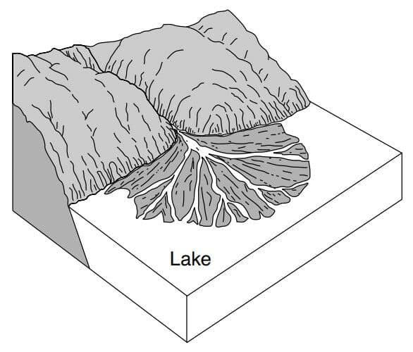
The landscape diagram below represents a fan-shaped feature that is composed of sediments that were transported and deposited by a stream entering a lake.
This fan-shaped feature is best identifi ed as a
The tendency of a mineral to split along flat surfaces indicates the mineral property called
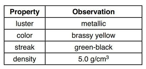
The data table below shows a student’s observations of a mineral sample.
Based on the student’s observations, the mineral can best be identified as
The diagram represents the Moon at different positions in its orbit around Earth. The phases of the Moon as seen by an observer in New York State have been labeled.
Which diagram best represents the new gibbous phase of the Moon as seen by an observer in New York State?

How many days (d) are required for the Moon to complete a cycle of phases from one full Moon phase to the next full Moon phase?

At which two Moon phases will the difference in height between high tide and low tide most likely be the greatest?
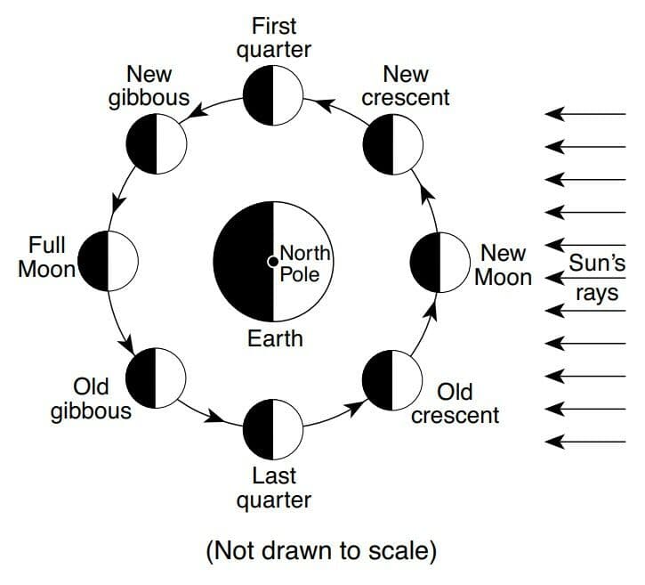
Eclipses do not occur each time that the Moon revolves around Earth because the Moon’s

The same side of the Moon always faces Earth because the period of revolution of the Moon is
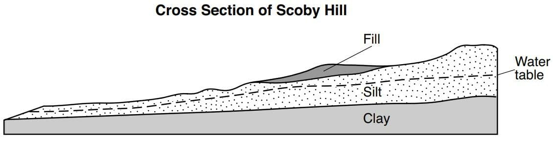
Scoby Hill Landslides
Scoby Hill is approximately 40 miles south of Buffalo, New York. The silt layer of Scoby Hill may have been unstable ever since it formed from glacial outwash approximately 12,000 years ago. Construction of a road required the addition of fill, which consisted of clay, silt, sand, and pebbles. The resulting landslides that occurred were a surprise because the gradient of Scoby Hill was thought to be too low for landslides. Geologists discovered that landslides easily started because of the weight of the fill. In order to decrease pressure on the silt layer, engineers decided to remove the fill and some of the silt layer to create a level surface for the road. In addition, drain pipes were installed to lower the water table and reduce the chance of future landslides.
The outwash sediment that formed Scoby Hill is best described as

Scoby Hill Landslides
Scoby Hill is approximately 40 miles south of Buffalo, New York. The silt layer of Scoby Hill may have been unstable ever since it formed from glacial outwash approximately 12,000 years ago. Construction of a road required the addition of fill, which consisted of clay, silt, sand, and pebbles. The resulting landslides that occurred were a surprise because the gradient of Scoby Hill was thought to be too low for landslides. Geologists discovered that landslides easily started because of the weight of the fill. In order to decrease pressure on the silt layer, engineers decided to remove the fill and some of the silt layer to create a level surface for the road. In addition, drain pipes were installed to lower the water table and reduce the chance of future landslides.
The maximum diameter of the particles in the fill was

Scoby Hill Landslides
Scoby Hill is approximately 40 miles south of Buffalo, New York. The silt layer of Scoby Hill may have been unstable ever since it formed from glacial outwash approximately 12,000 years ago. Construction of a road required the addition of fill, which consisted of clay, silt, sand, and pebbles. The resulting landslides that occurred were a surprise because the gradient of Scoby Hill was thought to be too low for landslides. Geologists discovered that landslides easily started because of the weight of the fill. In order to decrease pressure on the silt layer, engineers decided to remove the fill and some of the silt layer to create a level surface for the road. In addition, drain pipes were installed to lower the water table and reduce the chance of future landslides.
The drain pipes that were installed lowered the water table by
Scoby Hill Landslides
Scoby Hill is approximately 40 miles south of Buffalo, New York. The silt layer of Scoby Hill may have been unstable ever since it formed from glacial outwash approximately 12,000 years ago. Construction of a road required the addition of fill, which consisted of clay, silt, sand, and pebbles. The resulting landslides that occurred were a surprise because the gradient of Scoby Hill was thought to be too low for landslides. Geologists discovered that landslides easily started because of the weight of the fill. In order to decrease pressure on the silt layer, engineers decided to remove the fill and some of the silt layer to create a level surface for the road. In addition, drain pipes were installed to lower the water table and reduce the chance of future landslides.
In which New York State landscape region is Scoby Hill located?


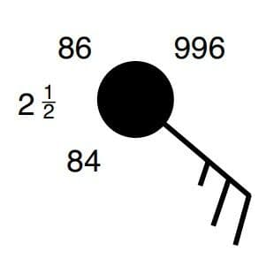
Which present-weather symbol represents the form of precipitation that is most likely occurring at this location?

What are the wind direction and the wind speed at this location?
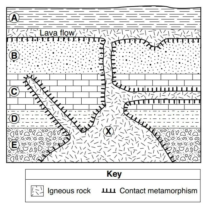
The cross section represents rock units labeled A through E that have not been overturned. A lava flow is represented between rock units A and B. Letter X represents a location in the igneous rock.
Rock unit A was formed most likely by

The cross section represents rock units labeled A through E that have not been overturned. A lava flow is represented between rock units A and B. Letter X represents a location in the igneous rock.
Which two minerals would most likely be found in the igneous rock if the rock is highly mafic?

The cross section represents rock units labeled A through E that have not been overturned. A lava flow is represented between rock units A and B. Letter X represents a location in the igneous rock.
Which metamorphic rock most likely formed at the interface between rock unit B and the igneous rock?