Loading...

NY Released Regents Exam - Earth Science (Jun 2022)
Quiz by NYSED Earth Science
Track each student's skills and progress in your Mastery dashboards
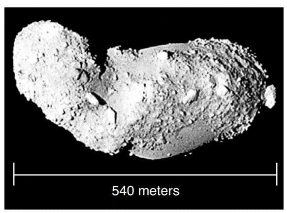
The image below shows the near-Earth asteroid Itokawa.
Which surface feature would be created if Itokawa hit Earth’s surface?

mountain valley
rift valley
impact crater
volcanic crater
The image below shows the near-Earth asteroid Itokawa.
Which surface feature would be created if Itokawa hit Earth’s surface?
The north end of Earth’s axis of rotation points toward
What is the approximate percentage of Earth’s surface that is covered by the hydrosphere?
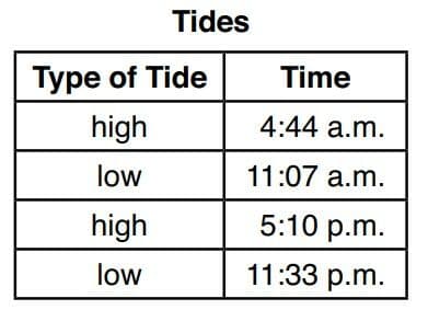
The table below shows the times of high tides and low tides for a coastal location.
How much time occurred between the high tides on this day?
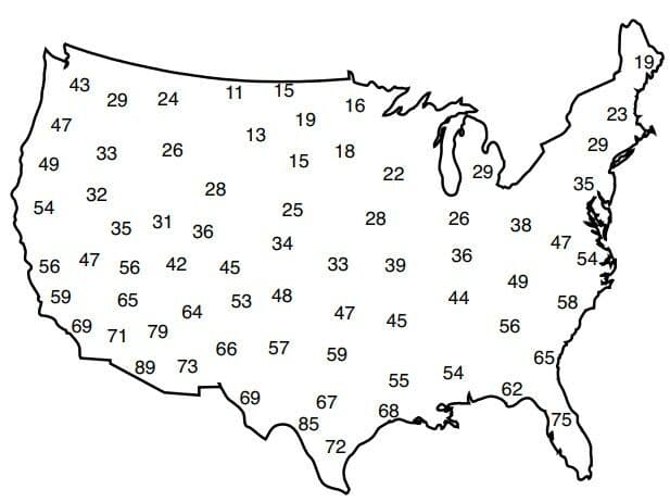
The map below shows a weather variable recorded at the same time across the United States.
According to the data on the map, which weather variable was most likely recorded?
The table below shows the dates of peak activity of four meteor showers for five different years. Meteor showers are named for the constellations in which they appear to originate, as observed from Earth.
Based on the data, the dates of these meteor showers appear to depend on the

The diagram below represents four different land surfaces of equal area.
Which area would most likely have the greatest permeability as each area receives the same amount of rainfall?

The diagram below represents a portion of the water cycle. Letters A, B, C, and D represent processes or features related to the water cycle. Arrows represent movement of water.
Which table correctly matches these letters with the processes or features related to the water cycle?

The subtropical jet streams are fast flowing air currents located in the atmosphere about 10 kilometers above the surface of Earth. In which layer of the atmosphere are the subtropical streams located?
Which substance given off by a volcano is most likely to cause global cooling following a large volcanic eruption?
The table below shows general climate conditions of four different locations, A, B, C, and D.
In which location is chemical weathering probably greatest, based on these climate conditions?

The picture below shows a calorimeter being used to demonstrate a method of heat transfer. One cup is filled with hot water, and the other cup is filled with cold water. A metal bar extends through the lids into the water in both cups. Thermometers record changes in temperature.
This calorimeter demonstrates the transfer of heat through the metal bar from

At the end of which geologic time period were the continents of South America and Africa joined together and entirely located south of the equator?
Which atmospheric cross section best represents the general air circulation over the North Pole?
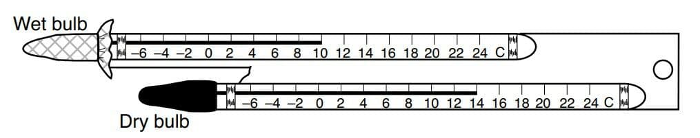
The diagram below represents a sling psychrometer.
Based on the wet-bulb temperature and the dry-bulb temperature, what is the approximate relative humidity?
The graph below represents the decay of a radioactive isotope into a stable disintegration product.
Which remains could be dated using this radioactive isotope?

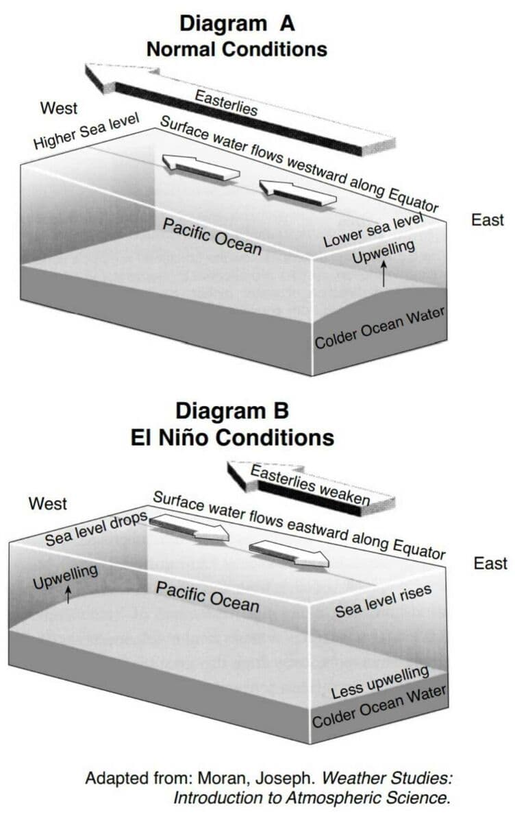
Block diagram A below represents normal surface ocean currents and the upwelling of colder water in the eastern Pacific Ocean. Block diagram B represents a reversal of surface ocean currents and decreased upwelling in the same region, initiating an El Niño event.
Warmer surface water builds up in the eastern Pacific Ocean during an El Niño event because the speed of the Easterlies
Ordovician-age crinoid fossils of tropical marine origin are found in the bedrock of the Hudson-Mohawk lowlands region of New York State. This provides evidence that New York State was once located at a
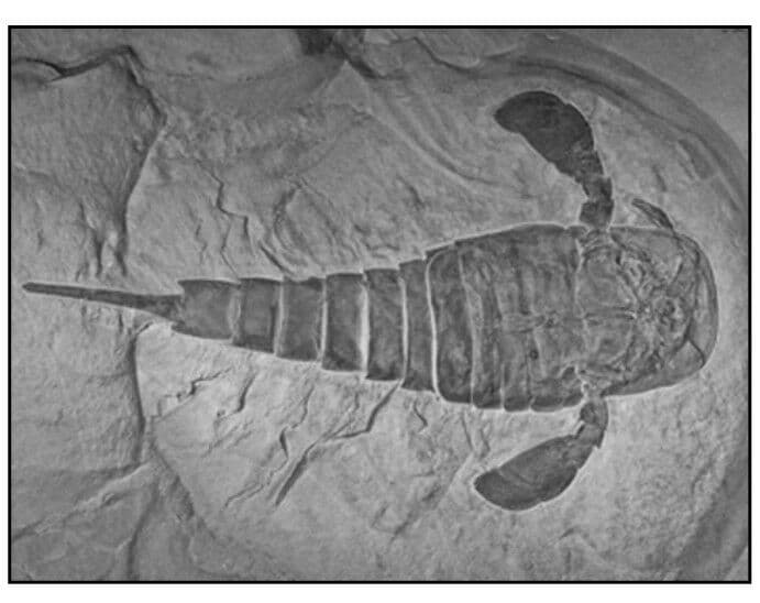
The photograph below shows the New York State fossil Eurypterus remipes.
Eurypterus fossils are most likely to be found in surface bedrock near
The study of fossil evidence suggests that humans
What is occurring at the Southeast Indian Ridge?
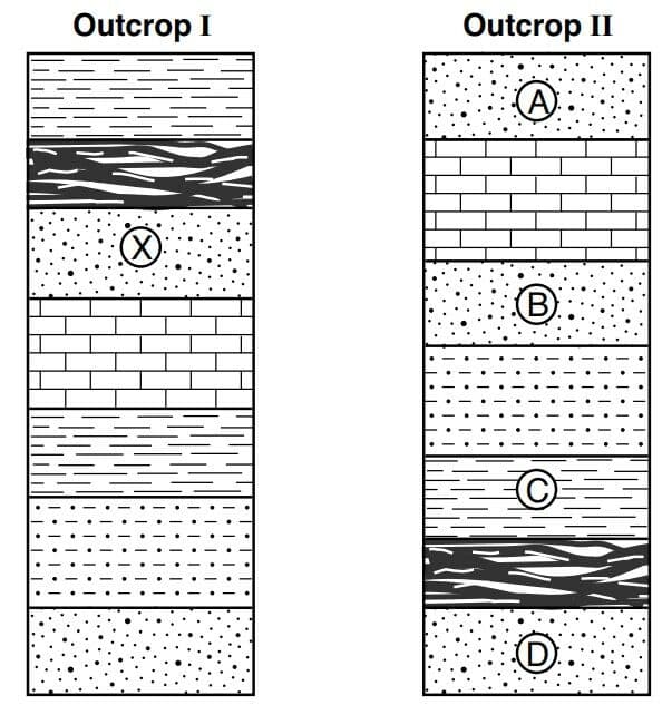
The cross sections below represent two rock outcrops labeled I and II. Letters A, B, C, D, and X identify rock layers. The rock layers have not been overturned.
Which rock layer in outcrop II best correlates with layer X in outcrop I?
Which igneous rock formed from magma that cooled slowly and is composed of 5% amphibole, 8% biotite, 15% plagioclase feldspar, 37% quartz, and 35% potassium feldspar?
A mudslide is most likely to occur on a hillslope having soil that is
The map below represents portions of three tectonic plates. Points A through D represent locations on Earth’s surface.
Which location is closest to a zone of rifting?

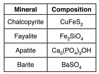
The table below shows the chemical formulas for four rock-forming minerals.
Which mineral contains the two most abundant elements by mass in Earth’s crust?
The map below represents a bridge over the meander of a stream. From the bridge, a student measures the stream velocity at locations A, B, and C.
Which table represents the most probable stream velocity recordings at each location?

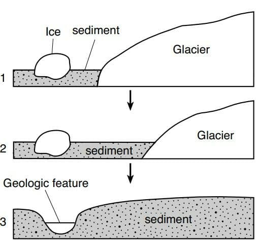
The sequence of diagrams below represent three stages in the formation of a geologic feature over time.
Which geologic feature is formed by this process?
Which mineral has cleavage in two directions and is commonly used to manufacture ceramics?
A mixture of rounded pebbles and sand was deposited in a river. Over time, these sediments were compacted and cemented together to form the sedimentary rock
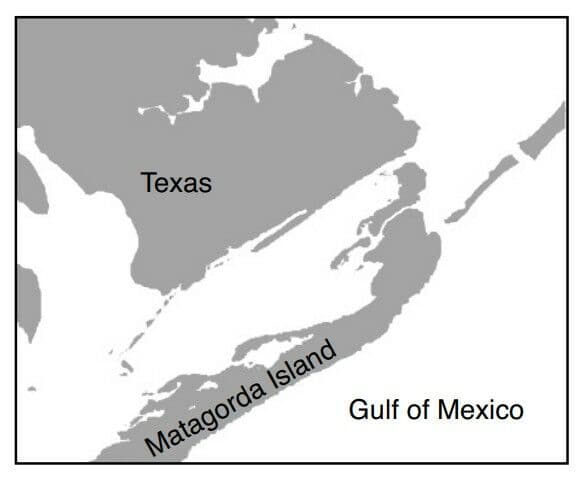
The map below shows a portion of Matagorda Island. This barrier island is located along the coast of Texas in the Gulf of Mexico.
Which agent of erosion is primarily responsible for the formation of Matagorda Island?
A primary difference between sedimentary rocks and nonsedimentary rocks is that
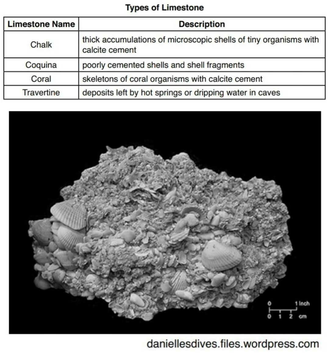
The data table describes some types of limestone.
Which limestone is classifi ed as inorganic?

The photograph below shows one type of limestone described in the table.
This type of limestone is best identified as
Whiteface Mountain
Whiteface Mountain, located in the Mount Marcy region, is one of New York State’s highest mountain peaks. Most of the surface bedrock on Whiteface is anorthositic gneiss made up of large, light-colored plagioclase feldspar crystals and dark mineral bands composed of amphibole, pyroxene, and garnet. The foliated crystal alignment in the gneiss was produced during a major tectonic event called the Grenville orogeny. Landslides have exposed steep slopes of this white and gray bedrock on the sides of Whiteface Mountain.
In the anorthositic gneiss, the mineral garnet is most likely observed in the

Whiteface Mountain
Whiteface Mountain, located in the Mount Marcy region, is one of New York State’s highest mountain peaks. Most of the surface bedrock on Whiteface is anorthositic gneiss made up of large, light-colored plagioclase feldspar crystals and dark mineral bands composed of amphibole, pyroxene, and garnet. The foliated crystal alignment in the gneiss was produced during a major tectonic event called the Grenville orogeny. Landslides have exposed steep slopes of this white and gray bedrock on the sides of Whiteface Mountain.
The texture of the gneiss indicates that the bedrock
Whiteface Mountain
Whiteface Mountain, located in the Mount Marcy region, is one of New York State’s highest mountain peaks. Most of the surface bedrock on Whiteface is anorthositic gneiss made up of large, light-colored plagioclase feldspar crystals and dark mineral bands composed of amphibole, pyroxene, and garnet. The foliated crystal alignment in the gneiss was produced during a major tectonic event called the Grenville orogeny. Landslides have exposed steep slopes of this white and gray bedrock on the sides of Whiteface Mountain.
The altitude of Polaris as seen by an observer on Whiteface Mountain in the Mount Marcy region will be approximately
The cross section represents a section of Earth’s lithosphere along the coast of Japan. The epicenter of a large magnitude earthquake that occurred on March 11, 2011 is indicated. Devastation occurred mainly in the low-lying coastal areas of Japan closest to the epicenter. Letter A represents a geologic feature.
Which type of tectonic plate boundary is represented in the cross-section?
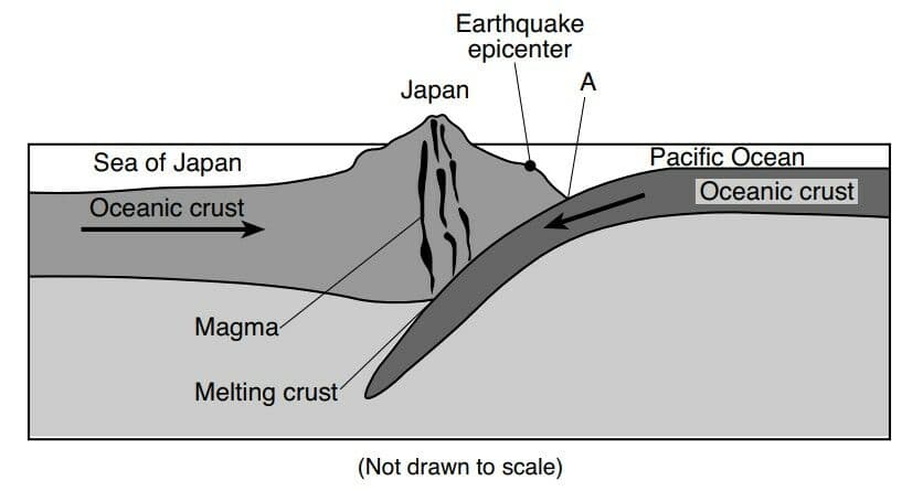
The cross section represents a section of Earth’s lithosphere along the coast of Japan. The epicenter of a large magnitude earthquake that occurred on March 11, 2011 is indicated. Devastation occurred mainly in the low-lying coastal areas of Japan closest to the epicenter. Letter A represents a geologic feature.
The geologic feature indicated by letter A is
The cross section represents a section of Earth’s lithosphere along the coast of Japan. The epicenter of a large magnitude earthquake that occurred on March 11, 2011 is indicated. Devastation occurred mainly in the low-lying coastal areas of Japan closest to the epicenter. Letter A represents a geologic feature.
What most likely caused the major devastation along the flat coastal areas of Japan as a result of this earthquake?
The cross section represents the effect of Earth’s atmosphere on energy from the Sun. Arrows labeled A, B, C, D, and E represent some possible paths of this insolation. The dashed arrows represent energy reradiated from Earth’s surface.
Which arrows represent reflected insolation?

The cross section represents the effect of Earth’s atmosphere on energy from the Sun. Arrows labeled A, B, C, D, and E represent some possible paths of this insolation. The dashed arrows represent energy reradiated from Earth’s surface.
Compared to path D, the amount of energy reaching Earth’s surface following path B is likely
The cross section represents the effect of Earth’s atmosphere on energy from the Sun. Arrows labeled A, B, C, D, and E represent some possible paths of this insolation. The dashed arrows represent energy reradiated from Earth’s surface.
Which type of surface material absorbs and reradiates the greatest amount of energy?
The graph shows the number of families (groups of closely related species) represented in the fossil record and five major mass extinction events in Earth’s history.
Which group of living organisms survived all five major mass extinctions?
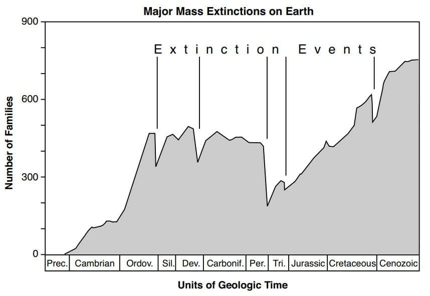
The graph shows the number of families (groups of closely related species) represented in the fossil record and five major mass extinction events in Earth’s history.
One group of organisms that existed on Earth before 550 million years ago was
The diagram represents the apparent change in direction of the swing of a scientific device over a period of five hours. This device provides evidence of Earth’s rotation.
Which diagram represents the correct direction of Earth’s rotation?

The diagram represents the apparent change in direction of the swing of a scientific device over a period of five hours. This device provides evidence of Earth’s rotation.
Approximately how many degrees does Earth rotate on its axis over this five-hour period?
